Community Center
CastleHellenthal - Manscheid
Wildenburg Castle
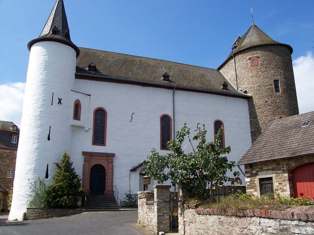
Wildenburg Castle is located in the North Rhine-Westphalian part of the Eifel, in the National Park municipality of Hellenthal (Euskirchen district).
The castle was built between 1202 and 1235 and is one of the few Eifel hilltop castles that has not been destroyed by war or demolition. It was the center of a dominion that stretched in the west to the present-day Belgian border and in the east to the gates of Steinfeld Abbey. As in the Middle Ages, the site can only be reached via a single road, today's Landesstraße 22, which leads from the valley of the Reifferscheid stream via Steinfeld to the Urft valley.
The Lords of the Castle and Dominion+
From the end of the 12th century, the dynasts of Reifferscheid exercised dominion in the area around Wildenburg. From these, the Wildenberg line branched off between 1202 and 1235. In addition to their core territory, the Lords of Wildenberg held distant possessions on the Rhine and Moselle, in the Hunsrück, and in other parts of the Eifel. They maintained good relations with their neighbors, such as the Dukes of Limburg, the Counts of Jülich, of Sponheim, and the Archbishops of Cologne. The male line died out in 1328, and the Wildenberg dominion and other possessions north of the Moselle fell to the Counts of Jülich; the castle became a Jülich sub-dominion. In 1715, the abbots of Steinfeld acquired the dominion and converted the castle house into a church in 1717. In 1794, French revolutionary troops marched in. The main castle became French national property but escaped auction because it was left to the newly founded parish in 1803 as a church and rectory.
Location and Buildings of the Castle+
The castle belongs to the group of spur castles and is located at an altitude of about 526 m above sea level at the end of a narrow mountain spur, extending far into the valley, which slopes quite steeply on three sides. A narrower and lower saddle connects it to the higher flank in the east. On the mountain spur, from east to west, lie the village, the outer bailey, and the main castle.
Its geographical location offered the village good protection but also prevented the emergence of a larger settlement. The only access was protected by a barrier (Grindel). The sandstone village cross at today's parking lot, whose chronogram IesVs CrVCIfIXVs saLVator MVnDI (Jesus the Crucified Savior of the World) yields the year 1789, already stood outside.
The castle complex, protected by a curtain wall and a neck ditch, was only accessible from the east via a drawbridge. In the course of filling the neck ditch, the drawbridge also disappeared. A section of the path named Op dr Bröck (On the Bridge) still commemorates it today. The formerly existing two gate systems of the outer bailey and the main castle have also disappeared today.
The Outer Bailey
Entering the outer bailey today, one sees on the left a half-timbered house, the House at the Gate (mistakenly called the Gatekeeper's House), which was originally the house of a castle knight. Its valley-side outer wall is formed by the old defensive wall, and the upper floor of the street front is cantilevered. The gables were once windowless because the building was located between the former gatehouse of the outer bailey and a barn. The year 1600 above the front door is misleading, as the house is mentioned considerably earlier. Adjoining it is the former Pallandt barn, converted into a residential house in the mid-20th century, with the alliance coat of arms of a Lord of Pallandt and his wife. The adjoining gardens were once built with farm buildings.
On the right side, one sees an elongated, representative building with a quarter tower at the northeast corner and a well in the courtyard. This is the former House Pallandt. It occupies the place where the defensive wall once ran and where the wine house and the church of 1562 stood. The House on the Poel (Pond), which took its name from the former pond located there and still differs from the rest of the house, was integrated. The new building was constructed around 1800 by Johann Franz Theodor Edmund Pallandt, who came from a bourgeois family whose origin lay in an illegitimate connection of the Trier Archdeacon Reinhard von Pallandt (+ 1572). The three sons of this Franz Theodor Pallandt (Christoph Reinhard, Wilhelm Joseph Maria, and Franz Anton Maria) succeeded in 1829 in being registered as barons in the nobility register of the Prussian Rhine Province. They were therefore allowed to call themselves von Pallandt from then on. In 1865, the eastern half of the building was sold by the heirs of Franz Anton von Pallandt; later, the other half went to the Prussian forestry administration, which established a forestry office there. Since 1917, this part has also been in private hands. The eastern half was acquired by the Catholic parish of Wildenburg in 1962 and, like the main castle, served as the house of the Episcopal Academy of the Diocese of Aachen until 2005. At that time, renovation measures were carried out, which, among other things, made the previous main entrance with the Pallandt coat of arms above it (in incorrect colors) superfluous.
The Main Castle
In the main castle, which was formerly additionally protected by a moat and a drawbridge, one first reaches the former castle house, the palas, flanked in the south by a stair tower and in the north by a residential tower, with the remains of the castle chapel already mentioned in 1263 on the upper floor, whose location can be seen from the small Gothic window to the right of a loophole. After the Wildenburg dominion passed into the hands of Steinfeld Abbey (1715), the palas was converted into a church, the stair tower with the still visible loopholes was made into a bell tower (with the bells e and fis cast by Martin Legros in 1777 and the bell cis cast by August Mark in 1954), and the sacristy was set up in the residential tower, now named Johannesturm after its patron saint.
The church is a rectangular hall building with doors and windows in red sandstone. On the south side, two rectangular windows from the former palas with their narrow slits and single-sided window seats are preserved. The main access is via an open staircase through a pilaster portal. Altars and pulpit are works of Steinfeld monks from the 18th century. On the high altar, in the center, we see the almost life-size wooden figure of the parish patron John the Baptist, on the left that of Saint Norbert of Xanten, and on the right that of Saint Hermann Joseph of Steinfeld. In the left side altar stands the wooden figure of the Mother of God with the Child, in the right that of the Guardian Angel. The most valuable figure is the 85 cm high seated figure of Saint Anne made of oak on the right side wall. It is a Rhenish work from the 15th century. The pulpit is crowned by the figure of Saint Michael. To gain space, side altars and pulpit were moved towards the main altar in 1957/58. At that time, the organ from Bürvenich near Zülpich in the three-part Baroque organ case from the 18th century was also replaced by a new one. From the organ loft, one has a view into the crooked, ribless cross-vaulted chancel of the former castle chapel, where the mensa substructure, a holy water niche in ashlar, and remains of Gothic painting are preserved. Below the organ loft hangs a 12th Station of the Cross in the form of a gold enamel sunken work from 1960. In 1987, a new celebration altar with the motif of the burning bush on the four identical bronze plates was consecrated. In the sacristy on the ground floor of the former residential tower, which is cross-vaulted without ribs like the church, a fireplace with the coats of arms of the married couple Edmund von Pallandt and Anna von Merode from 1553 is preserved. The square room is extended by wall niches; the seating niches of the cross windows are no longer present today. The cellar with the heating dates from more recent times. The sacristy can also be entered through an outside door since the mid-20th century.
The Johannesturm, approximately 18 m high overall with a horseshoe-shaped floor plan, has three further floors, all of which were heated. From the third, one reached the battlements, which ran along the east wall of the palas. The uppermost floor offered the guard visibility in all directions. The tower's wall staircase was removed during the conversion of the castle house into a church, so that the upper floors were no longer accessible. Since 1905, a stone external staircase leads to the second floor, from where the other two floors can also be reached.
Past the more recent rectory, one reaches the lower castle courtyard. Behind a garage building (formerly stables), one sees a bastion tower at the southwest corner with walls up to 4.40 m thick, which is called the Hexenturm (Witches' Tower) due to its role as a prison during the witch trial of 1628. It originated at the latest in the 16th century and seems to have been designed for artillery fire, without being able to accommodate larger cannons itself. The two circular, dome-vaulted, and windowless interior rooms of the two lower floors served as a prison. The room on the second floor is accessible from the lower castle courtyard through a Gothic door that is still preserved today and has a small side chamber, which was probably also used as a prison. The lowest room, 5 m deep, was the dungeon and was only accessible through a square access opening, the "Angstloch" (fear hole).
A staircase leads from the lower to the upper castle courtyard with the well. Here once stood the mighty square residential tower, which served as the keep. It had at least four floors and was connected to the palas. This keep was built in the 12th or early 13th century and was thus the oldest part of Wildenburg.
After Steinfeld Abbey acquired the castle, it had the keep demolished to erect a stately building in the style of a Baroque country palace to the west of it on the battlements. This building was the residence and official seat of the abbatial cellarer responsible for the Wildenburg dominion, thus a cellarer's office. It is a two-story building with a hipped gable roof and a facade with seven axes of simple rectangular windows in bluestone frames. Access is via a platform staircase in the middle. In the entrance hall, from where a wide Baroque platform staircase leads to the upper floor, to the left is first a representative former living room with a corner cabinet and stucco ceiling, which could be heated by a high stone fireplace. Its wood paneling shows abbatial coats of arms and emblems of Steinfeld Abbey. In the former spacious kitchen, the mighty smoke hood with its square stone posts is preserved. The modern kitchen and a dining room are on the right side.
From the cellarer's office, one reaches the two upper floors of the Hexenturm through a connecting wing, which is the remainder of the former battlements on the west side. Through the kitchen, one reaches the barrel-vaulted third floor, designed as a living room, with embrasures and window seats, which could be heated by a fireplace of gray sandstone in Renaissance forms. On the upper floor of the cellarer's office, a Baroque secondary staircase in platform form with board balusters leads to the fourth floor of the Hexenturm in the form of an attic, which the Steinfeld monks designed as a belvedere, offering an excellent overview of a large part of the former dominion.
After secularization, the cellarer's building served as a rectory and elementary school; from 1953 to 2005, it was an educational center of the Diocese of Aachen. During this time, extensive renovation measures were carried out to adapt the building to the new requirements. Today, the cooperative ProWildenburg eG, a joint venture of the city of Grevenbroich and the parish of St. Johann Baptist Wildenburg, operates a meeting, education, and recreation center there.
The former terraced gardens on the west side of the cellarer's office now serve other purposes.
Take Mobile History with you
You are reading this text for free. Premium adds what matters on the road: descriptions read aloud, sites found through your camera, whole regions taken offline.
- Every description, including the ~17,700 Premium sites
- Audio guide: have descriptions read to you on location
- AR finder: see sites through your camera, with distance and bearing
- Unlimited saved sites
14 days free, then from €2.99 a month. Cancel anytime.
Location: 50.4620, 6.4941