Museum
Military ObjectDillingen - Pachten
Westwallbunker Pachten
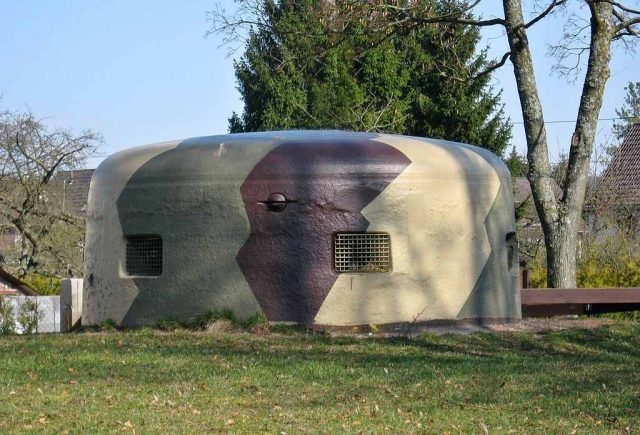
The Westwall Bunker (Pachten) is a preserved bunker of the Dillingen Westwall complex. Its excavation and restoration began in 2004 and was completed in 2008. The bunker has been a protected monument since 2006 and is accessible to the public as a museum bunker. It is located on Annastraße in the Pachten district.
Historical Context+
Only after the construction of the Westwall was well advanced did construction activities begin in Dillingen. While approximately 50 installations had already been erected by 1937, a new list of standard constructions was drawn up in 1938. The intensification of the Westwall expansion was announced on October 9, 1938, in Saarbrücken on the Befreiungsfeld. The listed bunkers were now exclusively built in the new B and A construction strengths. Construction began in 1939 and lasted until 1940. With 165 installations in an area of approximately 40 km², a high density of fortifications was created.
On December sixth, 1944, at 2:30 AM, the third battalion of the 358th US Infantry Regiment marched down the steep slope from Oberlimberg to the Saar riverbank. During the descent, the battalion became separated and could only regroup at 5:15 AM, to then cross the river south of the ferry (at the height of today's marina) with 8-man assault boats. Since the Germans did not expect an attack at this point, the Americans reached Wilhelmstraße without problems. When all companies had crossed by 7:50 AM and reached Pachten, they came under fire, presumably from Bunkers 20 and 17. They bypassed the bunkers and waited for the pioneers, who neutralized the bunkers with explosive charges. In the following weeks, bitter fighting took place in Pachten and Dillingen with heavy losses on both sides. Many bunkers were repeatedly reoccupied by the Germans, only to be recaptured by the Americans. When Dillingen was almost completely taken, the American units were withdrawn from the town by December 22 to be deployed in the Ardennes Offensive.
The Bunker+
The bunker is a standard construction of type 114 b and bears the designation WH-Nr. 20. However, it deviates from the standard design as it has a staircase. These special constructions with staircases were built particularly in the western part of the bunker chain, as they were located in the flood plain of the Saar. A crew of 12 men was planned. The base is at a depth of 6 m. The turret is a 20P7, has six embrasures and weighs 51 t. The turret was equipped with 2 MG34 machine guns, whose optical sight allowed for the lateral offset of the barrel. This protected the shooter's head from enemy fire. Observation of the terrain was carried out via three angled optics (manufacturer Busch), each with a 150-degree field of view, as well as via a central optic, which was fixed in the center of the turret and could be rotated 360 degrees. A vertical shaft with a rectangular cross-section was provided as an emergency exit. Evacuation was then possible through the now accessible shaft via a steel door at the upper end.
Restoration+
The reason for the bunker's restoration was its impending demolition by its administrator, the Federal Agency for Real Estate Tasks. Consequently, within the framework of the activities of the Dillingen History Workshop, the restoration of the bunker in the form of a museum was initiated. Soon after the start of excavations in 2004, the "Projekt Westwall" association was founded in Pachten in 2005.
Take Mobile History with you
You are reading this text for free. Premium adds what matters on the road: descriptions read aloud, sites found through your camera, whole regions taken offline.
- Every description, including the ~17,700 Premium sites
- Audio guide: have descriptions read to you on location
- AR finder: see sites through your camera, with distance and bearing
- Unlimited saved sites
14 days free, then from €2.99 a month. Cancel anytime.
Source: Wikipedia · Licence: CC BY-SA 4.0 · Image: https://commons.wikimedia.org/wiki/File:Pachten_Bunker_Kuppel.jpg
This description draws on the facts documented in the linked Wikipedia article; Wikipedia content is licensed under CC BY-SA 4.0. Wording and editing: Mobile History.
Location: 49.3497, 6.7116