The City Wall can be visited
Town FortificationStralsund
Town Fortification Stralsund
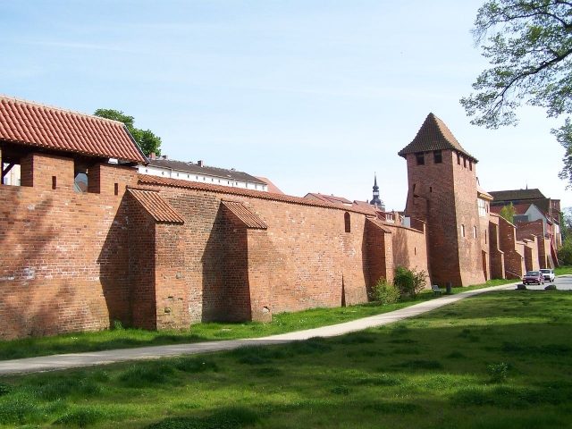
The Stralsund city fortifications were a system of solid city walls, city gates, as well as bastions and ponds, which surrounded the Hanseatic city of Stralsund since the middle of the 13th century and were intended to protect it from attacks.
The fortifications of the city, which was bordered on the seaward side by the Strelasund, were further expanded after Stralsund became Swedish in 1648. Stralsund was a bridgehead in Swedish Pomerania, and its defense was considered immensely important. Until the occupation of Stralsund by Napoleon's troops in 1808, the facilities were maintained and expanded. The French had the city walls razed. Ferdinand von Schill had them re-erected during his coup, but by this time they had largely lost their great importance for the protection of the city. After the de-fortification of the city in 1873 under Prussian rule, the facilities were largely demolished, the bastions were later developed into green areas, and all but three city gates were removed.
Today, two city gates are still preserved, and the city wall has been restored in some places or faithfully reconstructed. The preserved city fortifications are part of the UNESCO World Heritage ensemble "Historic Old Towns of Stralsund and Wismar".
City Wall+
The city wall, which surrounded the entire city for a length of 3100 meters and originally consisted of earth ramparts equipped with palisades, was first mentioned in 1256. Since these ramparts offered little protection, stone walls were erected after Lübeck's attack on the young city, founded in 1234 on the Strelasund. By 1320, the city wall was completed. In the 13th century, the fortification still consisted of palisades. Gradually, in the late 13th century, it was replaced by a stone wall with towers and battlements. Large sections of the city wall with watch houses are still preserved on Am Knieperwall and Fährwall. Of the ten city gates, only the Kniepertor and Kütertor still exist.
The city wall was always maintained and expanded. In 1808 and 1809, the walls were razed by order of Napoléon Bonaparte, which Major Ferdinand von Schill briefly reversed. From 1815, the Prussians continued to expand the walls and fortifications. After the lifting of Stralsund's fortress status in 1873, the city fortifications became superfluous and were quickly dismantled. Reasons for the haste were the need for space for new buildings and the increase in traffic, which had been hindered by walls and city gates. In a contract from 1879, Prussia, to which Stralsund now belonged, transferred the city fortifications to the city of Stralsund. By 1887, the demolition work on most of the former fortifications was completed.
Today, only a small part of the city wall remains. In some cases, the city wall is formed by the outer walls of residential buildings and monastery complexes. Thoroughly renovated in the 1980s by Polish specialists and after 1990 as part of urban renewal, this preserved part of the city wall offers an imposing sight.
City Gates and Bastions+
Stralsund had ten city gates. Some were completed even before the actual city wall; for example, the Fährtor is documented as early as 1278, while the city wall was first mentioned in 1287. Today, only two of the city gates remain.
The city gates were distinguished between water gates (gates built on the seaward side of Stralsund) and land gates. The beach gates included (from northwest to southeast) the Fährtor, the Semlower Tor, the Badentor, the Heilgeisttor, the Langentor, and the Frankentor; the land gates included (from north to south) the Kniepertor, the Hospitaler Tor, the Kütertor, and the Tribseer Tor. The gates were designed as an inner gate (towards the city) and an outer gate. Between these was a passage (Zwinger), which widened towards the outer gate. In addition, the passage was usually laid out at a slight angle to prevent shooting through the open gates. Further components of the city gates were drawbridges, barrier chains, and, of course, wooden, iron-clad gate wings, which were quickly closed at night and in case of defense. The city gates were open from sunrise to sunset. To obtain money for the maintenance of the city fortifications, the rooms in the city gates were leased to merchants. They stored goods here; however, in case of defense, they had to remove their goods immediately.
Until the lifting of Stralsund's fortress status in 1873, the bastions were an important part of the defense facilities. In a contract from 1879, Prussia, to which Stralsund now belonged, transferred the city fortifications to the city of Stralsund. Most of the once 13 bastions were subsequently greened and used for recreational purposes.
Badentor
The Badentor, one of the sea gates, was first mentioned in 1277. It had a width of 9.75 meters and a height of 10.30 meters. It was located at the seaward end of Badenstraße towards the waterway. In 1877, it was demolished to no longer hinder increasing traffic.
Blau-Turm-Bastion
The Blau-Turm-Bastion is located between the Frankenwall and the Frankenteich. The eponymous Blue Tower was a powder tower demolished in 1865, which in turn got its name from the medieval designation "blue" for dark, enclosed rooms. From 1897 to 1900, the higher boys' school, later named Gerhart Hauptmann School after one of its students, was built on the site. The building was completely renovated from 1997 to 2004 and continues to serve as a school.
Fährtor and Fährbastion
The Fährtor, one of the sea gates, is first mentioned in a document in 1278, even before the first mention of the city wall. It was located at the seaward end of Fährstraße towards the waterway. On the seaward side, the width was 32.30 meters, and on the city side, 21.80 meters. The depth was 20.50 meters and the height 17.10 meters. In the lower part of the two-part building were accommodations for the ferrymen. Even today, the oldest pub on the European mainland ("Zur Fähre") can be found here. The Fährtor fell victim to increasing traffic in the late 19th century and was demolished. Parts of the gate were integrated into the new construction of a residential building in 1997.
The Fährbastion is located between the Strelasund and Seestraße and is also known as the Wet Triangle. Here, on the Sundpromenade, there is a memorial stone for "those lost at sea," sailors who died during voyages.
Frankentor
The Frankentor, one of the sea gates, was first mentioned in a document in 1278, even before the first mention of the city wall. It was located at the seaward end of Frankenstraße towards the waterway. It received its name from Frankenstraße, in which it was located; this in turn was named after a Franke (or Vrancke) family in the Middle Ages. Therefore, there is no connection to the Franks. In 1863, the Frankentor was demolished.
Heilgeisttor and Heilgeistbastion
The Heilgeisttor, one of the sea gates, was first mentioned in a document in 1279, even before the first mention of the city wall. It was located at the seaward end of Heilgeiststraße towards the waterway and also received its name from Heilgeiststraße. Remains of the gate were removed in 1853.
The Heilgeistbastion is located between the Langen Kanal and the street Am Langenwall. Today, a parking lot is located on it.
Hospitaler Tor and Hospitaler Bastion
The Hospitaler Tor, one of the land gates, was first mentioned in a document in 1278, even before the first mention of the city wall. It was located at the end of Mönchstraße towards the Knieperwall and the Hospitaler Bastion, as well as the then Hospitaler Damm leading over the Knieperteich. The remains of the gate were removed in 1881. A memorial plaque attached to the city wall in Mönchstraße has commemorated the Hospitaler Tor since December 2005.
The Hospitaler Bastion is located between Knieperwall and the northern part of the Knieperteich, in front of the former Hospitaler Tor. It was predominantly used as a parade ground and was redesigned in 1885 into a garden according to designs by garden architect Ferdinand Jühlke. On November 28, 1886, a war memorial was inaugurated on the bastion. This was demolished in the 1950s. A bunker has been located under the bastion since the 1950s, which has been used as a bat roost since the early 1990s. The former gardens are now used as a children's playground.
Johannisbastion
The Johannisbastion is located between Fährwall and Seestraße. Today, the fire station of the Stralsund professional fire brigade is located on this site.
Katharinenbastion
The Katharinenbastion is located between Knieperwall and the southern part of the Knieperteich. The former bastion has been landscaped. A bunker has been located beneath it since the 1950s.
Kniepertor and Knieperbastion
The Knieperbastion is located between Fährstraße or Seestraße and the Schill Monument. Casemates stood on this bastion, in which, among others, Schill's followers were imprisoned. From 1911 to 1913, the municipal Lyceum was built here, whose successor, the Hansa-Gymnasium, is still housed in this building today. In front of the building, the former Schillanlagen have been horticulturally restored since 2003.
Kronlastadiebastion
The Kronlastadiebastion is located between Am Fischmarkt street and the Querkanal. The half-timbered house located here, built in 1865, was initially used as a shed for cannon carriages, later as a grain storage.
Kütertor and Küterbastion
The Küterbastion is located between Knieperwall and the Küterdamm in front of the Kütertor. A memorial stone with the inscription "Remember 1914 and 1918", inaugurated on July 23, 1923, was located here and removed after 1945. From 1929, a small zoo with various animals was located here. Initially, deer were kept here (the so-called Hirschgarten), and later, until the early 1990s, birds were presented. Today, there is a playground there.
Langentor
The Langentor, one of the sea gates, was first mentioned in a document in 1287, even before the first mention of the city wall. It was located at the seaward end of Langenstraße towards the waterway. It received its name from the street in which it was located. Remains of the gate were removed at the end of the 19th century to avoid hindering increasing traffic.
Mühlenbastion
The Mühlenbastion between Frankenwall or Tribseer Damm and the Frankenteich was landscaped in 1865. Today, a kindergarten stands here.
Schützenbastion
The Schützenbastion, located between Frankenwall, Karl-Marx-Straße and Weidendamm and the Frankenteich, received its name from its function as a shooting range. The bastion was enlarged in 1945 by filling it with rubble from the city bombed by the Allies on October 6, 1944. Today, the Stralsund bus station is located here.
Semlower Tor
The Semlower Tor, one of the sea gates, was first mentioned in a document in 1277, even before the first mention of the city wall. It was located at the seaward end of Semlower Straße towards the waterway. It was 13.30 meters wide, 17 meters deep, and 22.65 meters high and was used for residential purposes and as a grain storage. In 1599, it was rebuilt. In World War II, it was severely damaged in the bombing night of October 6, 1944. A ruin after the war, its future use was long debated. Since the GDR and the city of Stralsund lacked funds for reconstruction at that time, the remains of the gate were blown up on June 29, 1960, despite protests. Remains of the gate were integrated and made visible in an adjacent house, renovated in 1998.
Tribseer Tor and Tribseer Bastion
The Tribseer Tor, one of the land gates, was first mentioned in a document in 1278, even before the first mention of the city wall. It was located at the end of Tribseer Straße towards the Knieperwall or Tribseer Damm. In 1715, the Swedish King Charles XII, coming from his Turkish exile, entered the city through the Tribseer Tor. In 1770, the inner and outer gates were severely damaged by the explosion of the Köpkenturm, and then repaired. In 1877, the gate was removed. Today, the former Reichsbank building stands in its place.
The Tribseer Bastion is located between Frankenwall, Knieperwall and Bahnhofstraße, as well as between the Frankenteich and the southern part of the Knieperteich, in front of the former Reichsbank building. It received its name from a family named Tribsees. It is impressively landscaped. Since September 1997, there has been a memorial for displaced persons here.
Weingartenbastion
The Weingartenbastion between Frankenwall and the Frankenteich served as a fairground until the 1960s. Since then, a parking lot was located here, which was replaced by a multi-story car park in 1996. A bunker has been located under the bastion since the 1950s.
Dams and Bridges+
Frankendamm
The Frankendamm ran through the area of Stralsund called Franken. Its current form resulted from the razing of the fortifications after the end of Stralsund's fortress period. Like the other streets or districts with the name component Franken, it was not the Franks as an ethnic group that gave it its name, but a wealthy merchant family named Vranko or Franken. After this family from the later Frankenstraße (the family lived at the beginning of this street, which justified naming it after them), other streets, such as the Frankendamm, and even city areas were named over time. The Frankendamm has officially borne this name only since 1869. However, this path was already referred to as "dammno vranconis" in 1317. Before 1869, the relatively wide street was called Am Landwege. The section between the city center and the slaughterhouse was called Frankenkronwerk until 1953. From November 7, 1953, to November 16, 1961, the entire street was named Josef-W.-Stalin-Straße after Stalin.
Knieperdamm
The Knieperdamm (first mentioned in 1319) ran through the area of Stralsund probably named after a citizen family Knieper. It also served as a dam for the city ponds and as a dam to protect the ponds, used as a source of drinking water, against the water of the Strelasund flowing in during floods. Its current form resulted from the razing of the fortifications after the end of Stralsund's fortress period.
Tribseer Damm
The Tribseer Damm (first mentioned in 1306) was named after the Stralsund council family von Tribsees. As early as around 1270, a Conrad von Tribsees is mentioned in documents. The Tribseer Damm was named after this family, which is considered one of the oldest Stralsund families and provided several councilors. The family probably originally came from Tribsees. The dam also served as a dam for the city ponds and as a dam to protect the ponds, used as a source of drinking water, against the water of the Strelasund flowing in during floods. Its current form resulted from the razing of the fortifications after the end of Stralsund's fortress period.
Weidendamm
In 1919, the Weidendamm was artificially filled to allow smoother traffic into the city. At that time, it bore the name "Zuckerdamm" (Sugar Dam), as it led almost directly to the old Stralsund sugar factory. Since the dam, lined with willows, could no longer handle the traffic, a wider four-lane road, the Karl-Marx-Straße, was built next to it. Both roads enclose the Schützenbastion (see above), where the current bus station is located.
Küterdamm
The Küterdamm was named after the butchers who processed animal entrails (the "küt") and practiced their trade nearby. Its current form resulted from the razing of the fortifications after the end of Stralsund's fortress period.
Take Mobile History with you
You are reading this text for free. Premium adds what matters on the road: descriptions read aloud, sites found through your camera, whole regions taken offline.
- Every description, including the ~17,700 Premium sites
- Audio guide: have descriptions read to you on location
- AR finder: see sites through your camera, with distance and bearing
- Unlimited saved sites
14 days free, then from €2.99 a month. Cancel anytime.
Source: Wikipedia · Licence: CC BY-SA 4.0 · Image: https://commons.wikimedia.org/wiki/File:Stadtmauer_%282008-05-05%29.JPG
This description draws on the facts documented in the linked Wikipedia article; Wikipedia content is licensed under CC BY-SA 4.0. Wording and editing: Mobile History.
Location: 54.3158, 13.0872