The Town Fortification can be visited
Town FortificationMemmingen
Memmingen Town Fortification
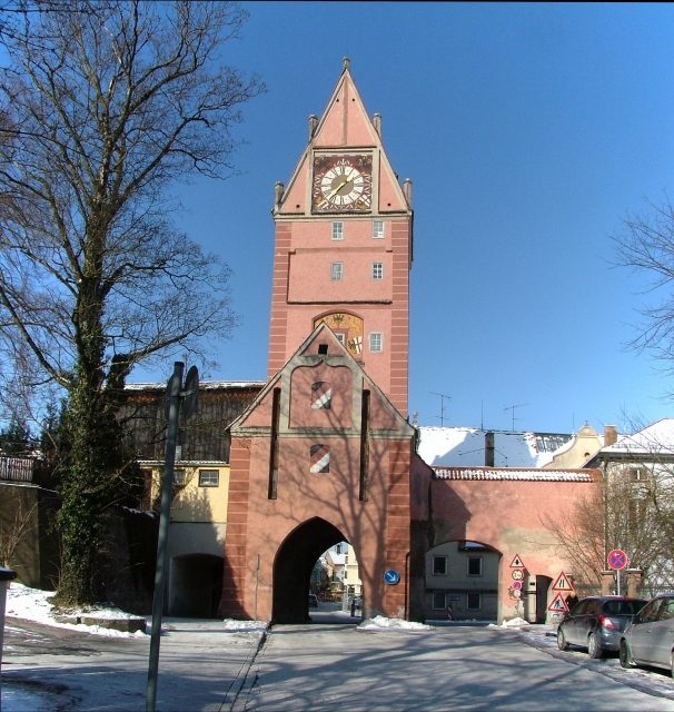
Parts of the fortifications in Memmingen still exist around the historic city center. The remains include the listed ramparts with the city wall, as well as the surviving gates and towers. The fortifications served to defend the city and as living space for municipal employees.
The former three villages, Memmingen, the Kalchervorstadt, and the Wegbachsiedlung, grew together into a single entity over time, which can also be seen in the defensive structures. Memmingen was expanded three times over three centuries. Only with the construction of the Einlass in 1475 were the fortifications completed, marking the end of the city's development process. They consisted of 28 gates and towers and a three-kilometer-long city wall, as well as the ramparts, moats, and earthworks in front of it.
Up to the 12th Century+
The first ring of walls encircled the so-called Welfenstadt. Excavations around the Antoniterkloster revealed remains of a defensive wall, which probably existed before 1000. City gates were mostly built of stone at that time, but there is no firm evidence for this. The first stone-built defensive walls were probably constructed around 1170/1180, at the latest by 1230. These included four city gates, one of which still exists today. The wall belt stretched from the northern Notzentor over the eastern inner Kalchtor, the southern Obertor to the western Westertor. Towers must have already existed at the four corners, but they were mostly demolished or rebuilt during the expansions. It is also not known where the probably fortified castle of the Welfs was located. Formerly it was assumed to be on the site of the later Antoniterkloster, today it is believed that this villa or burgus was located near today's Kalchstraße/Ratzengraben at the inner Kalchtor.
At the Hexenturm, old tuff stone ashlar blocks from around 1170 can still be seen in the lower floor. The Kerkerturm and an unnamed tower on the west side between the Kerkerturm and the Westertor must also have been built during this construction phase. The stump of this unnamed tower is now used as a residential building. Further tower constructions could not be proven. This is probably related to the complete removal of the city wall on the east and south sides during the second and largest city expansion.
13th Century+
After the city had grown and become Staufer, and the first monasteries had settled in the suburbs, a first expansion of the city wall had to be considered. By 1268, the Kalchervorstadt, also called Stauferstadt, was provided with a wall belt. In the course of this expansion, the eastern border of the city, which existed until the mid-19th century, was reached. The Hafendeckelturm was built, the Hexenturm reached its current size, and a tower was erected at the current intersection of Bahnhofs-/Maximilianstraße, and one at the height of today's Rosengasse. The Kalchtor (also called Augsburger Tor) formed the end of the Kalchervorstadt.
14th Century+
The second city expansion was the largest expansion of Memmingen in the Middle Ages. The area called Wegbachsiedlung or Oberstadt enclosed the area from Weinmarkt in the north to Hohe Wacht in the south. During this expansion, the entire southern part of the previous city wall was demolished, and the city moats, some of which are still visible today, were filled in. During the renovation of Maximilianstraße in 2006, remains of the fortifications in the form of wooden palisades were found, which probably served as an additional defense against enemies before the actual city wall. According to current research, nothing remains of the walls themselves. The lively construction activity at Weinmarkt and Maximilianstraße removed the last remnants of the walls. However, the former ramparts can still be recognized by the unusually wide street for Memmingen's conditions.
From 1340 to 1395, a total of three new gates, the Lindauer Tor, the Kempter Tor, and the Lindentörlein as a pedestrian gate, as well as several new towers, were built. In the west, five towers were built between Hohe Wacht and Lindauer Tor, one between Schweizer Berg and Lindauer Tor, and one at Schweizer Berg. The east of the city was relatively weakly equipped with fortifications, as the Haienbach was dammed there to form the so-called Gschwöllt Wasser, which made it almost impossible for attackers to storm the city from the east. The entire east became a swampy area with a water level of about 20 centimeters due to the damming of the stream.
A moat was dug around the entire city, which ran very shallowly on the east and south sides, as protection was also provided there by various streams. The north and west could be defended relatively poorly, which necessitated a sophisticated system of redoubts, moats, and walls.
15th Century+
During the third city expansion, the so-called Ulmer Vorstadt was included in the fortifications. The Ulmer Tor was built as the northernmost city gate. It was flanked by the Luginslandturm and the white Mehlsackturm. On the east side, the Bettelturm was built as another defensive tower. On the west side, the Schwalbenschwanzturm was to secure the city's defense. These construction works were completed in 1445. As the last construction phase, the Einlaß was built on the east side in place of the old watchman's house in 1475.
The largest ramparts of the city were built on the west side of the Ulmer Vorstadt. Due to the rising terrain, the city architects had to proceed with particular care, as a moat was not possible. Simultaneously with the walling of the Ulmer Vorstadt, the Große Rondell and the Hohe Wacht with the Nudelburg, as well as rampart walls around the entire city, were built in the south of the city wall.
16th to 18th Century+
Memmingen was never besieged or captured until 1525. Only during the peasant uprisings did the peasants try to storm the city. In the Thirty Years' War, Memmingen was besieged several times and captured for the first time, which severely damaged the city's fortifications. One of the fiercest battles was the siege and capture by the Bavarian and imperial troops in 1647. Almost the entire western city wall was so severely destroyed by artillery fire that the Lindauer Tor and the Wester Tor had to be rebuilt afterwards. The east side was also severely affected by the destruction of the Kalchtor. Only the north and south of the city remained unscathed. The city owed this to its strategically favorable starting position in the north and the well-developed ramparts in the south. Even the new cannons could not achieve anything here. Afterwards, however, a reinforcement and expansion of the redoubts and ramparts were necessary. These were partly moved far in front of the city. However, this did not help against the surprise attack of the Bavarian troops in the War of the Spanish Succession. In 1702, the city, like Ulm, was taken by surprise, captured after three days, and thus became Bavarian for the first time. Elector Maximilian II built the Red and Black Barracks for his troops on the west side of the city wall.
Memmingen was to be expanded into a Bavarian state fortress in 1702. However, the project did not materialize due to the early withdrawal of the Bavarians and the return of Memmingen as a free imperial city to the Empire. According to the plans of the French military engineer Tardiff, further, intricately built circumvallation systems with 34 redoubts were to be built in front of the actual city fortifications. This would have made Memmingen practically impregnable at that time.
19th Century+
After the siege and capture of the city by the Bavarians in the Napoleonic War, Napoleon ordered the demolition of the city's defenses. Only through the pleas of the city's population and the mediation of Baron von Lupin was Napoleon persuaded to demolish only the four largest and most important towers. Thus, the Luginsland and the white Mehlsack of the Ulmer Vorstadt, the Hafendeckelturm of the Kalchervorstadt, the large Pechturm, and the tower of the Hohe Wacht fell. All ramparts had to be removed and the moats leveled.
Only a few years later, the then mayor von Zoller had a city moat in the north of the city, the Ratzengraben, filled in and turned into a park (today's Zollergarten). He also had part of the city wall reduced to a height of about 2.5 meters and parts of the battlements removed.
The largest wave of demolition of the city's defenses occurred with the construction of the railway from 1863. Almost the entire eastern part of the fortifications was demolished, including the Wasserturm protecting the Wasserkunst, the Kalchtor, the Lindentörlein, and the small Pechturm. Around this time, the Notzentor, the last gate in its original 13th-century form, was also demolished. The citizens of the Ulmer Vorstadt felt economically disadvantaged by the narrow gate passage. The Bavarian State Office for Monument Protection in Augsburg intervened against the demolition of the Kempter Tor by the Wegbachvorstadt. It only allowed a breach in the wall on the east side so that the larger wagons could enter the city unhindered. These demolitions were the last. The remaining gates and towers were used as dwellings until after the Second World War.
20th Century to Today+
The two bombing raids in World War II in 1945 left almost no trace on the fortifications, as the attacks were limited to the station area in the east, where everything except the Pulverturm had already been demolished and leveled in the 18th century.
Today, the gates, towers, city wall, and remaining moats are carefully maintained. The fortification system with its five gates, five towers, and approximately 1.4 kilometers of city wall is considered one of the best-preserved city defenses in Germany. The city wall around the Hohe Wacht has been included in the Haller List, which lists the most important and best-preserved medieval fortifications. The gates and towers are used by various groups of the Fischertagsverein. The moats filled in the 19th century are mostly used as park landscapes. Only on the west side have city villas been built and large gardens laid out. A green belt has been created almost around the entire old town, which is only interrupted in the east by the railway station and the adjacent development.
Take Mobile History with you
You are reading this text for free. Premium adds what matters on the road: descriptions read aloud, sites found through your camera, whole regions taken offline.
- Every description, including the ~17,700 Premium sites
- Audio guide: have descriptions read to you on location
- AR finder: see sites through your camera, with distance and bearing
- Unlimited saved sites
14 days free, then from €2.99 a month. Cancel anytime.
Source: Wikipedia · Licence: CC BY-SA 4.0
This description draws on the facts documented in the linked Wikipedia article; Wikipedia content is licensed under CC BY-SA 4.0. Wording and editing: Mobile History.
Location: 47.9807, 10.1820