The City Wall can be visited
Town FortificationFriesach
Town Fortification Friesach
A unique feature of the town was the double market situation in the 12th century. At the foot of the Virgilienberg, between 1124 and 1300, the Gurk market of Friesach, originally located further south and dating back to the possessions of Saint Hemma, was established. This meant there were two separate markets in the town with two market lords, the Bishop of Gurk and the Archbishop of Salzburg. The latter ultimately prevailed as the sole market lord in the early 13th century.
The market was elevated to a city in 1215. Friesach experienced its heyday under Archbishop Eberhard II (1200 to 1246) and developed into the second-largest city of the Archdiocese of Salzburg and the most important city in Carinthia. Friesach was not only an economic but also a religious center of this period.
At the end of the 13th century, after conflicts between the Archbishops of Salzburg and the Habsburgs and Bohemians, the city was conquered, plundered, and destroyed three times within a few decades. The city remained in the possession of the Archbishops of Salzburg until 1803 but lost its significance and could no longer build on the economic and cultural flourishing of the Middle Ages.
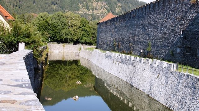
The first ring wall of the city fortifications was already built around 1200. However, due to its extensiveness, it was difficult to defend, and the city of Friesach was conquered three times in the years 1275, 1289, and 1292. Still in the 13th century, the decision was made to build the new, smaller ring wall. The city fortification consists of the actual wall, ten to eleven meters high, and a lower curtain wall about nine meters in front of it. In between lies the moat, fed by groundwater. This is followed by a city moat about 15 meters wide and almost ten meters deep. The lower parts of the wall date from the late 13th century, younger sections from the first quarter of the 14th century, and the majority of the curtain wall and the battlements from the 15th century. In addition to the northern Neumarkter Tor, the eastern Olsator, and the southern Sankt Veiter Tor, the fortification also had the Heidentor on the hillside west of the Virgilienberg and the Sacktor between Rotturm and Petersberg, which still exists today. The Sankt Veiter and Neumarkter Gates were demolished in 1845 as part of road widening, and the Olsator in 1873 after the construction of the train station.
Take Mobile History with you
You are reading this text for free. Premium adds what matters on the road: descriptions read aloud, sites found through your camera, whole regions taken offline.
- Every description, including the ~17,700 Premium sites
- Audio guide: have descriptions read to you on location
- AR finder: see sites through your camera, with distance and bearing
- Unlimited saved sites
14 days free, then from €2.99 a month. Cancel anytime.
Source: Wikipedia · Licence: CC BY-SA 4.0 · Image: http://www.wehrbauten.at/ktn/kaernten.html
This description draws on the facts documented in the linked Wikipedia article; Wikipedia content is licensed under CC BY-SA 4.0. Wording and editing: Mobile History.
Location: 46.9529, 14.4064