The Town Fortification can be visited
Town FortificationFriedberg
Friedberg Town Fortification
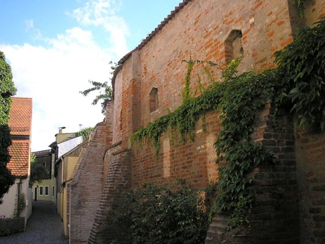
The medieval town fortifications of Friedberg (Aichach-Friedberg district, Swabia) were built starting in 1409 as a border fortress by the Dukes of Bavaria-Ingolstadt against nearby Augsburg and to secure the customs post at the Lech crossing (Hochzoll). In addition to large parts of the ring wall, the stumps of 14 defensive towers have also been preserved; the gates were removed in the 19th century.
Friedberg Castle was already built in 1257 as an advanced bulwark against the city of Augsburg. The city was founded in 1264 by Duke Ludwig II, "the Bearded" (memorial stone in the city parish church). The founding charter includes the planned city's layout, and the chessboard-like arrangement is still recognizable today. Friedberg is one of numerous city foundations of the 13th century in Old Bavaria; other planned cities with an approximately square layout include Neustadt an der Donau or Kelheim. The original fortification of the settlement consisted only of a palisade wall, but a brick wall is already documented around 1400.
The partially preserved fortifications were built in brick construction starting in 1409. The exposed strategic location of the ducal city at the gates of the imperial city of Augsburg led to numerous war-related devastations, which necessitated a strengthening of the fortifications. The Augsburgers first attacked the ducal city in 1296. Further attacks occurred in 1372 and 1388. In the 15th century, the city suffered greatly during the conflicts between the Munich and Ingolstadt dukes.
Even after the significant destruction during the Thirty Years' War, reconstruction took place on the original layout. In 1703, imperial troops partially demolished the fortifications (War of the Spanish Succession).
In the 19th century, the gates and some sections of the wall fell. Other sections of the fortifications were built over, the walls mostly incorporated as outer walls into residential buildings.
Description+
The old town of Friedberg is located south of the castle on the Lechleite, which here rises 50 to 60 meters above the Lech valley. The elevated position alone provided effective protection against attacks from the Lech plain, which was supplemented by the strong fortifications and the castle.
To the west, the wall rises directly above the steep slope. In the northwest, the castle (former fortress) is connected to the city fortifications by a connecting wall; the corresponding northeastern section of the wall has disappeared.
The regular layout (approx. 350 x 300 meters) reveals the planned design of the city. On the Lechrain, the course of the wall follows the natural slope edge in an arc to the northeast; subsequently, an open space and the neck ditch separate the city and the castle.
The ring wall is largely built over and integrated into buildings, the former dry moat filled in. The west side facing the Lech valley is best preserved. Here, the fortification stands partially free and at its original height of about five meters. Buttresses support the construction. The base of the former battlement is clearly visible, and some embrasures (keyhole embrasures in niches) can also be seen. In the southwest, a short section of the battlement has been reconstructed.
The stumps of several semicircular shell towers protrude outwards from the wall; their rear sides were formerly open to offer no cover to an invading enemy. The towers are usually topped by sloping lean-to roofs. The corner towers of the ring wall are round. The water tower (water reservoir 1604-1888) in the southwest has a 17th-century superstructure; its southeastern counterpart collapsed in 2003 during construction work. The further fate of the ruin is uncertain.
The former "Lower or Augsburg Gate" was already removed in 1793 during the regulation of the mountain road (memorial plaque next to the wall gap). Around 1812, the "Jägertor" between the city and the castle fell, and in 1868, the five-story "Upper or Munich Gate" in the east also fell.
Take Mobile History with you
You are reading this text for free. Premium adds what matters on the road: descriptions read aloud, sites found through your camera, whole regions taken offline.
- Every description, including the ~17,700 Premium sites
- Audio guide: have descriptions read to you on location
- AR finder: see sites through your camera, with distance and bearing
- Unlimited saved sites
14 days free, then from €2.99 a month. Cancel anytime.
Source: Wikipedia · Licence: CC BY-SA 4.0 · Image: https://commons.wikimedia.org/wiki/File:Friedberg_-_Stadtmauer_5.jpg
This description draws on the facts documented in the linked Wikipedia article; Wikipedia content is licensed under CC BY-SA 4.0. Wording and editing: Mobile History.
Location: 48.3548, 10.9797