The Town Fortification can be visited
Town FortificationAhrweiler
City Wall Ahrweiler-Obertor
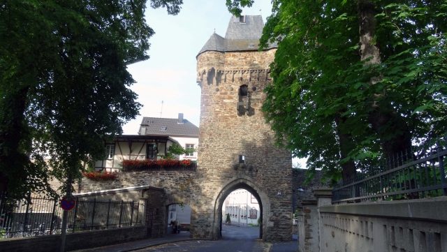
The town fortifications in Ahrweiler, a district of Bad Neuenahr-Ahrweiler in northern Rhineland-Palatinate, have been documented since the middle of the 13th century. The first records for the moat are from 1261, for the town gates from 1297, and for the wall from 1298. The Ahrweiler town fortifications are protected as a cultural monument.
The old town of Ahrweiler is still almost completely surrounded by the 1800-meter-long town wall. Four gate systems still provide access. The town moat is partly preserved between the Obertor, Adenbachtor, and Niedertor. The walled inner-city area covers approximately 18 hectares. In addition to the four town gates, three defensive towers can still be seen.
Town Moat
The oldest town accounts of Ahrweiler document expenses for masonry work in the Faulengraben. The town moat, or more precisely, the four town moats, followed this course: from the Obertor to the Adenbachtor was the Jeuchengraben, from the Adenbachtor to the Niedertor the Weilergraben, from the Niedertor to the Ahrtor the Faulengraben, and from the Ahrtor to the Obertor the Bitzengraben. The Bitzen-, Jeuchen-, and Weilergraben are named after the respective fields located there. For the Faulengraben, the lack of a gradient between the two town gates is noteworthy. This section of the moat likely earned its name from its consistently stagnant water. The division of the town moat into four parts has topographical and hydraulic engineering reasons, as water does not flow uphill. The highest points (in meters above sea level) of the individual gates are: Obertor 106.2, Adenbachtor 109.2, Niedertor 103.7, and Ahrtor 103.9. Thus, a uniform water level for the moat was technically not possible. The mill pond simultaneously crosses the town and the moat. This mill pond was the main water source for the town moat. The inlet at the Obertor and the outlet at the Niedertor were crucial for the technical equipment of the moat and its aforementioned sections. These points were protected with grilles against intruders. The individual moat sections therefore each had their own water level. They were separated from each other by retaining walls and sluices, so that in case of threat, the sluices could be raised and the moat sections could drain into the mill pond or the Bitzengraben. Here, at the lowest point, there was an overflow to the Ahr. According to the latest findings, there also seems to have been a drainage ditch along Joerresstraße (formerly Schellengasse) at the Faulengraben, at the height of Plätzerstraße, leading to the mill pond. During the annual draining of the mill pond, the town moat was also laid dry for 14 days and repaired, just like the mill ditch. It should be noted that the moat was only filled with water during wartime. In peacetime, the moat sections served as hay meadows, and even as vineyards.
Town Wall
The 1800-meter-long town wall does not stand on a continuous foundation but is founded on arches and pillars. This construction not only saves material but primarily has static reasons. The wall as a whole becomes elastic and can more easily absorb possible shocks, such as earthquakes. The pillars themselves only extend 75 to 80 cm deep into the ground. The arches have a height of 50 to 100 cm and a chord length of 3.60 m. These arches were initially open. Today, they are poorly bricked up because many residents have their cellars behind them. To protect against intruders, they were, of course, secured by dense thickets. A thicket was understood to be impenetrable undergrowth, usually with thorns and prickles. With a height of 6 to 8 m, the base of the wall tapers from 1.20 m at the bottom to 0.90 m at the top of the wall crown.
Between the Ahrtor and the Niedertor, there are regularly recurring holes (at intervals of 140–150 cm) measuring 25 by 30 cm in the town wall. These holes are 3 to 3.50 m above the ground. Through these holes, called putlog holes, the cantilever beams passed. These, in turn, supported the wooden battlement situated on the wall crown. This special form of battlement, called a Hurde or Hurden gallery, can be proven with certainty for the section of the Faulengraben, but probably also for the area of the Weilergraben, where these putlog holes are only sporadically visible. In the area of the Bitzengraben, between the Obertor and the first residential house, a parapet or breast wall can still be seen on the wall crown. This was a simplified variant of a battlement. It offered cover and allowed enemies to be fought from a commanding height on the wall crown. A battlement, such as the one built during the reconstruction after the destruction of the Ahrtor in the Second World War, apparently did not exist in the Ahrweiler defensive system.
Town Gates and Defensive Towers
In addition to Ahrweiler's landmarks, the four preserved or reconstructed town gates, the Kanonenturm (half-tower in the wall ring), the Bitzenturm, and the Schlösschenturm should also be mentioned. The names of all three mentioned defensive towers are not historically documented.
Obertor (Walporzheimer Tor, Gesemer Tor)
Western four-story gate tower with an overhanging upper floor. Four corner turrets and a pointed hip roof. On the outside, there is a pointed arch gate with a portcullis slot, as well as a machicolation and three embedded stone balls commemorating the siege by the Burgundian troops of Charles the Bold in 1476. Named after the neighboring village of Walporzheim or the deserted settlement of Gesem.
From the period after 1487, we have documented the Gesemer Portze (Obertor), the Adenbach Portze (Adenbachtor), the Nidderste Portze (Niedertor), and the Arportze (Ahrtor). However, a number of other urban fortifications from this period are also documented: Calcktoirn (1487 – first mention in each case), Sintziger Toirn (1495), the Thorn opposite Orsbeck's house (1603), the Thorn opposite Hambach's Johann's house (1603), Prümer Wijchuis (1492), and the Wijchus in the Arhoiden (1508). Such a Wichhaus – also called a watchtower – was a small, projecting watch and observation tower at the corner or bend of the town wall. It served as an observation tower and was sometimes also a position for a shooter. The exact location of the two Wichhäuser can only be speculated. It is certain that the Prümer Wichhaus was in the area of the Jeuchengraben in the Adenbachhut and the Ahrhuter Wichhaus was near the Ahrtor. The tower opposite Orsbeck's house can only have stood in the Niederhut, approximately at the height of today's breakthrough. The tower opposite Hambach's Johann's house could have been the current Kanonenturm. The Sinziger Turm can be located without doubt. This tower – called Metternicher Turm in 1603 – can be seen in Galibert's map of 1775 in the Weilergraben. All these towers were constructed as half-shell towers open towards the town side, as can still be seen exemplarily at the current Bitzenturm. Around 1500, the Adenbach and Obertor were also designed as three-walled gates, so they were open on the town side.
Wartime+
The entire Ahrweiler fortification system faced its major test in 1474, when the town was besieged and attacked for several weeks from April 14 onwards by the troops of Archbishop Ruprecht during the Archdiocesan Feud. Under the command of field captains Eberhard von Arenberg and Count Dietrich von Manderscheid, heavy weapons were used against the fortifications. Manderscheid alone billed his client for eight tons of gunpowder and one ton of crossbow bolts after the withdrawal on May 12. The archiepiscopal troops had to "break up in shame," as the Koelhoff Chronicle reports, but the damage to the defensive structures must have been very significant. The oldest surviving town account from 1487 still reports, 13 years after the event, extensive repair work on the towers, gates, and walls. Masonry, carpentry, roofing, and locksmith work were necessary for years to restore the gates to a defensive state. The outer gates, which each town gate possessed, also had to be renovated.
The Armament of the Town Fortifications+
Initially, only sparse information is available regarding the armament of the Ahrweiler defensive structures. The first mention of a cannon appears in the town accounts in 1495. We learn that a small cannon tower was erected at the Niedertor. As early as 1487, hackbuts are mentioned in the oldest town account. These hackbuts were an early form of muzzle-loader that, due to its weight, could only be used stationary. Furthermore, there are reports of gunpowder purchases and the construction of a dedicated municipal gunpowder mill.
At the beginning of the 17th century, the information becomes more precise. A handover protocol from the municipal master builder Hubert Hansmann in 1632 reports on cannons, hackbuts, muskets, and gunpowder. In the tower of the Ahrtor, the town's arsenal, there were at that time three large field culverins on carriages, furthermore 11 double hackbuts, two half-hackbuts without a loading mechanism, and seven chamber guns. In the powder chamber were three barrels of powder and a small keg with little powder, several cast balls, some lead, and saltpeter.
End of Meaningful Town Fortifications+
The Thirty Years' War did not spare the Ahr valley. At the end of 1632, Swedish troops under General Baudissin advanced into the Ahr valley. Ahrweiler was besieged and had to surrender. On December 11, 1632, the Swedes marched into the town. In 1642, Hessians and Weimarers under Marshal Guébriant entered Ahrweiler. Whether there were battles beforehand, and especially whether the town was shelled, cannot be determined due to the poor source material.
Four years later, during the War of the Palatine Succession, the French under Turenne, with 14 cannons, surrounded the town. Here too, it cannot be said with certainty whether the town surrendered without a fight. On November 4, 1673, the Dutch were in Ahrweiler. In 1688, the French were in the town, which they set ablaze upon their withdrawal a year later.
The medieval fortification system was no longer up-to-date due to advances in military technology, especially the development of artillery. Richer cities had replaced their defensive structures with modern fortress constructions. This was not an option in Ahrweiler due to the high costs and the confined valley location. Since the Thirty Years' War, the outer gates to the town gates were no longer mentioned. Likewise, no repairs to the battlements are reported. The moats were never flooded again. They had lost their purpose and value. Only the wall and the town gates were maintained and kept by the town to – especially at night – keep unwanted persons out of the town and to be able to control persons entering the town.
Take Mobile History with you
You are reading this text for free. Premium adds what matters on the road: descriptions read aloud, sites found through your camera, whole regions taken offline.
- Every description, including the ~17,700 Premium sites
- Audio guide: have descriptions read to you on location
- AR finder: see sites through your camera, with distance and bearing
- Unlimited saved sites
14 days free, then from €2.99 a month. Cancel anytime.
Location: 50.5403, 7.0917