The City Wall can be visited
Town FortificationSpeyer
Town Fortification Speyer-Heidentürmchen
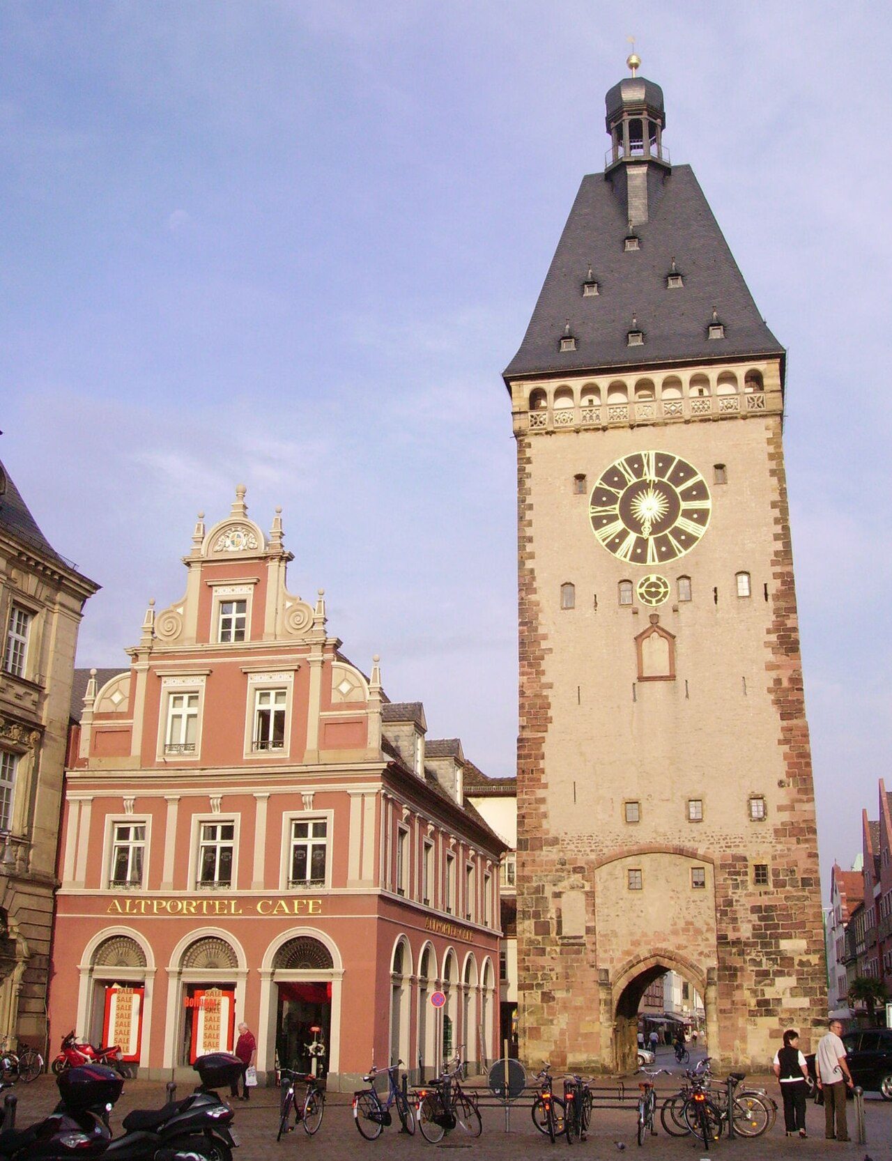
Speyer city fortifications in the narrower sense refer to the Speyer city wall, the fortress system, today its remains, which the Bishops of Speyer as city lords and later the citizenry of the city of Speyer erected from approx. 948 to protect the city from military attacks.
Starting from the first Ottonian city wall built between 946 and 950 on behalf of Bishop Reginald as the new city lord, the fortifications consisting of walls, up to 71 towers, gates, posterns, and partly bricked and partly watered moats were built, maintained, strengthened, later also extended by four suburbs, and repeatedly modernized over centuries with great effort. Over time, a Landwehr (defensive line) with Landwehr moats, ramparts, Landwehr hedges, and watchtowers was also built as a preliminary defense, see: Speyer Landwehr.
Fundamental qualitative changes included the reconstruction of the fortifications in response to the emergence of the crossbow in the 14th century and later the reinforcements and extensions in response to the emergence of the first firearms in the 15th century, when berm walls, gun emplacements, and Zwinger (outer bailey) were added. This military system came to an end with the destruction of the city and its fortifications ordered by Louis XIV in 1689.
The devastated city, abandoned for 11 years, was rebuilt starting in 1698, and from 1700 with the first gates until 1730, a city wall was also re-erected, which, however, was no longer intended to enable military defense. Its purpose was merely to offer protection against raids, thieves, robbers, riff-raff, and excesses, and to channel the flow of goods at the gates. This wall thus had police functions until approx. 1814 (last expansion plan).
With the arrival of the Bavarian administration in 1816, this phase ended, and the period of demolition and stone salvage began. In 1819, the Landkommissariat permitted the demolition of the inner structures; the outer wall initially had to remain standing up to a height of three meters. By 1826, most of it was destroyed, but demolition continued until 1958, when a demolition permit was granted for the Falkenturm.
Today, the modest remains of the Speyer city fortifications, apart from the Altpörtel, are listed as historical monuments.
Fortifications during Roman rule and the transitional period+
In a broader sense, Speyer city fortifications also refer to the fortifications during the four centuries of Roman rule.
These were initially the three successive castella: the first A, built under Drusus from approx. 10 BC; the second B, built after Varus' defeat in 9 AD; and the third C, under Tiberius, approx. 30 AD. The civilian settlement of Noviomagus, which grew around the castella, was initially unsecured. For protection, the Romans settled the Nemetes, a Germanic federated tribe, in the area around Speyer and made their Noviomagus, as Civitas Nemetum, the capital of the Nemetergau. Emperor Valentinian I secured Nemetum in 369 with a strong fortress building with walls approx. 2.5 meters thick and a military harbor. After the successful conquest by the Vandals and Alans at the turn of 406/407, the Romans initially settled Burgundians, who were relocated to present-day Burgundy in 430. All Roman administration ended in 454 with the assassination of the Western Roman military commander Aetius. Ultimately, the Franks prevailed in the Speyergau, who initially built no fortifications but lived in unfortified villages. The Salian Frankish Duke Conrad the Red transferred the city, initially administered by a count, to Bishop Reginald of Speyer in 946, who had the first Ottonian city wall built between approx. 946 and 950 in view of the Hungarian campaigns.
Chronology at a glance+
- 946 to 950 Construction of the Ottonian city wall under Bishop Reginald of Speyer during the time of the Norman and Hungarian invasions, when it became clear that the use or expansion of old Roman walls often meant salvation for defense. The construction was also a symbol of the bishop's unrestricted city lordship. Initially, the complex consisted only of walls and gates.
- 955 End of the Hungarian threat with the Battle of Lechfeld.
- Around 1050 Construction of a new ring wall shifted to the west to secure the city's expansion due to the cathedral construction, the early Salian city wall. Its course roughly corresponded to the presumed western end of Civitaes Nemetum before the first Alamannic invasion of 275.
- Presumably soon after 1080, the late Salian wall extension to the northeast (Augustinerlinie) was carried out to secure the renewed city expansion during the second phase of cathedral construction.
- The cathedral hill enclosure was also extended in late Salian times.
- Presumably during the time of Bishop Johannes (1090–1104), the late Salian northern enclosure (Hirschgrabenlinie) was built.
- 1116 The siege by Archbishop Adalbert of Mainz failed at the Speyer city wall.
- 1128 King Lothar III, with Archbishop Adalbert of Mainz and the Bishop of Speyer, besieged the city for three months in vain.
- 1129 Lothar III again enclosed the city with his army. After six months of successful defense, the city surrendered due to hunger.
- 1134 Duke Conrad of Swabia besieged the city but had to retreat before a relief army of Lothar III.
- 1201 Anti-King Otto IV besieged King Philip of Swabia in Speyer. Philip escaped by ship, Otto IV had to break off the siege with losses.
- 1206 King Otto IV again besieged Speyer but had to retreat after a futile siege before a relief army of King Philip of Swabia.
- Around 1230, during the late Staufer gate tower construction, the first four gate towers were erected: the Altpörtel, the Weidenpörtel, the Rheinpörtel, and the Neupörtel.
- Around 1240, the stacking area at the new harbor on the north side of the city (Fischmarkt) was walled, using bricks for the first time instead of sandstone.
- Around 1250, Lord Uto's corner tower on the cathedral hill spur, the Utenturm, was erected.
- Around 1260, the wall was reinforced with blind arches.
- From 1278, the citizens reinforced the Salian wall from the cathedral hill and began to enclose the bishop's territory, with whom they were in dispute, with extraordinarily high towers. During the 1280 tower construction, the following were erected:
- Corner towers: Roter Turm, Judenturm, Schmiedturm
- Bachfront: Salzturm, Holztorturm, Tränktorturm
- Rheinfront: Nikolauspfortenturm, Heidenturm, Zimmerleutturm, Metzgerturm, Armbrusterturm
The sight of the Uten-, Zimmerleut-, Armbrusterturm, of Rheinpörtel, Schmiedturm, Neupörtel, Altpörtel, and Roter Turm still impressed the English travel writer Coryate 300 years later. Coryate, who had traveled from London via France to Northern Italy, visited Speyer on his return journey from Venice. He wrote about his impression of Speyer: It is surrounded by strong walls with towers as high as our church steeples, the highest towers in a wall I saw on my journey. A remarkable judgment after Coryate's long journey. An idea of such a tower-fortified wall is conveyed today by the Museggmauer in Lucerne.
- 1331, after the Severins-Sturm, the tower "zum halben Dach" (Schusterturm), the tower "zum Maulbronner Garten" (Pulverturm), and presumably the Bäckerturm were built.
- By the 14th century, four suburbs had formed: to the southwest the Gilgenvorstadt, to the northwest the suburb Altspeyer (the former village of Altspeyer), to the northeast the suburb "überm Hasenpfuhl", and to the southeast the Marxenvorstadt (also Fischervorstadt).
- The Gilgenvorstadt was walled between 1320 and 1334, presumably 1324 to 1326.
- The suburb "überm Hasenpfuhl" was walled around 1335 and secured with the Lauerturm.
- 1340 the Bachriegelbauten were erected: the Obere Bachriegel, the Untere Riegel (Gackturm), and the Untere Lauerpforte.
- By 1350 at the latest, the Bäckerturm and the Eurichsturm, perhaps also the Judenturm, were built.
- The St.-Marxen-Vorstadt was walled around 1365.
- The suburb Altspeyer was walled around 1380. The village of Spire (later Altspeyer), located north of Speyer, already had a wall since approx. 1080, as did the Jewish quarter created there.
- 1410 the second windmill was built on the Windmühlenturm (Roter Turm).
List of Towers and Gates of the Speyer City Fortifications+
Inner Ring
- Altpörtel or Old Castle Gate
- Eurichsturm
- Windmühlenturm
- Roter Turm
- The Törlein at the Roter Turm
- Weidentorturm
- Bäckerturm
- Judenturm
- Schusterturm
- Pulverturm
- Lauerturm
- Oberes Lauerpförtchen
- Unteres Lauertor
- Salzturm
- Salztor
- Holztorturm
- Riegel at the exit of the city stream
- Tränktorturm
- St.-Nikolaus-Pfortenturm
- Utenturm
- Heidenturm, today Heidentürmchen
- Zimmerleutturm
- Metzgerturm
- Rheintorturm
- Schmiedeturm
- Neupörtel
Gilgenvorstadt
- Alexturm
- Turm zum Drachen (Tower of the Dragon)
- Turm zur Taube (Tower of the Dove)
- Turm zum Bock (Tower of the Buck)
- Turm zum Hahn (Tower of the Rooster)
- Turm zum Engel (Tower of the Angel)
- Streifertorturm
- Turm zum Kranich (Tower of the Crane)
- Turm zur Nachtigall (Tower of the Nightingale)
- Turm zum Greifen (Tower of the Griffin)
- Turm zum Falken (Tower of the Falcon)
- Turm zum Adler (Tower of the Eagle)
- St. Gilgen Gate
- Kreuztorzwinger
- Heilig-Kreuz-Tor (Holy Cross Gate)
- Turm zum heiligen Kreuz (Tower of the Holy Cross)
- Turm zum Papagei (Tower of the Parrot)
- Turm zum Wächter (Tower of the Watchman)
- Turm zum Strauß (Tower of the Ostrich)
- Turm zur Meise (Tower of the Titmouse)
- Mühltörlein
- Turm zur Atzel (Tower of the Magpie)
- Turm zum Kauz (Tower of the Owl)
- Turm zum Habicht (Tower of the Hawk)
- Turm zur Schwalbe (Tower of the Swallow)
- Turm zum Storchen (Tower of the Stork)
- Klüpfelstor and -turm
Suburb Altspeyer
Western and northern flank
- Turm zur Linde (Tower of the Linden Tree)
- Turm zur Tanne (Tower of the Fir Tree)
- Turm zur Eiche (Tower of the Oak Tree)
- Turm zur Erle (Tower of the Alder Tree)
- Turm zur Birke (Tower of the Birch Tree)
- Heiliggrabtor (Holy Sepulchre Gate)
- Diebstor- und turm (Thieves' Gate and Tower)
- Woogturm
Eastern flank
- Wachthäuslein zum Fuchs (Watchman's House of the Fox)
- Wachthaus zum Wolf (Watchman's House of the Wolf)
- Wachthaus zum Pfau (Watchman's House of the Peacock)
Suburb "überm Hasenpfuhl"
- Oberer Speyerbachriegel, the battlement crossed the stream with two large arches, which were blocked by two wooden grates. A gap in the grate of the western arch allowed passage for barges and drift wood.
- Allmendtörlein
- Turm zum Bären (Tower of the Bear)
- Turm zum Löwen (Tower of the Lion)
- Turm zum Widder (Tower of the Ram)
- Farrenturm
- Kühtor or Rheintor
- Nebentörlein beim Gackturm
- Gackturm
- Tor zum Bachstaden
St.-Markus-Vorstadt
- Fischertorturm
- Äußeres Fischertor (Outer Fishermen's Gate)
- Stephansturm
- Euwenturm
- Schleicherturm (formerly Tower behind the Wasenmeister)
- St.-Markus-Tor (St. Mark's Gate)
- Hammelturm
- Rohrturm
- Inneres St.-Germanstor (Inner St. German's Gate)
- Äußeres St.-Germanstor (Outer St. German's Gate)
Moat System+
The moat system consisted of the
- Inner city moat, including Postgraben, Hirschgraben, Mühlbach, Karmelitergraben, Alexgraben,
- Suburb moat in front of the Gilgentor, with Gilgengraben, Klüpfelsgraben,
- the city moats in the lowlands: Germansgraben, Graben an der Steingasse (Old Harbor), the Froschau, the Marxengraben, the Graben am Spich, the Hasenpfühler Rheinarm, the Speyerbach, the Speyerbach in front of Altspeyer, the Eselsdamm, the Graben in front of the Hasenpfühler Mauer.
Current Remains+
The comparatively very modest remaining parts of the Speyer city fortifications are today protected as a monument zone. Besides the Altpörtel, the Heidentürmchen (in the eastern cathedral garden), the lower part of the Schmiedturm (at the southern end of Zeppelinstraße), the following towers still exist: From the fortifications of the Gilgenvorstadt, the three wall stumps of the round towers Zum Drachen, Zur Taube, Zum Bock, and remains of the Schwalbenturm with its moat. From the fortifications of the suburb "überm Hasenpfuhl", two rectangular wall towers Zum Bären and Zum Löwen (near Bärengasse and Löwengasse) and wall remains of the former arched bridge and barrier Riegel. City wall remains can be found in the area of the houses Am Hannelturm 1, Allerheiligenstraße 23, 24-31, Bahnhofstraße/Am Klipfelstor, Bahnhofstraße/Adenauerpark, Domgarten, Domplatz 6, Farrenturmstraße 9-19, Feuerbachstraße 1, Fischergasse 11-29, Große Pfaffengasse 1-5, Gutenbergstraße 1, Hasenpfuhlstraße 37,38, Hirschgraben, Holzmarkt 4, Karl-Leiling-Allee 5, Lauergasse 2-7, 11-16, 21-37, Mühlturmstraße 12-26, Neufferstraße/Am Drachenturm, Petschengasse 4,6, Pistoreigasse 1,2,8-14, Rheintorstraße 6-9, Roßmarktstraße 11-23,26,27,35. St-Markus-Straße 43, Schiffergasse 22, 23, Steingasse 17, Zeppelinstr. 1,3,5,7,9, 31,33,35,37,39
Most publicly accessible parts of the former city fortifications are well preserved or restored (e.g., Fischergasse 11-29 rear), while other remains of the city wall are in a rather dilapidated state (e.g., the rear course in Allerheiligenstraße 24-31 or in Große Pfaffengasse 1-5).
Take Mobile History with you
You are reading this text for free. Premium adds what matters on the road: descriptions read aloud, sites found through your camera, whole regions taken offline.
- Every description, including the ~17,700 Premium sites
- Audio guide: have descriptions read to you on location
- AR finder: see sites through your camera, with distance and bearing
- Unlimited saved sites
14 days free, then from €2.99 a month. Cancel anytime.
Source: Wikipedia · Licence: CC BY-SA 4.0 · Image: Immanuel Giel / Public domain via Wikimedia Commons
This description draws on the facts documented in the linked Wikipedia article; Wikipedia content is licensed under CC BY-SA 4.0. Wording and editing: Mobile History.
Location: 49.3172, 8.4444