The tower can't be visited
Town FortificationStansstad
Schnitztower (Stansstad)
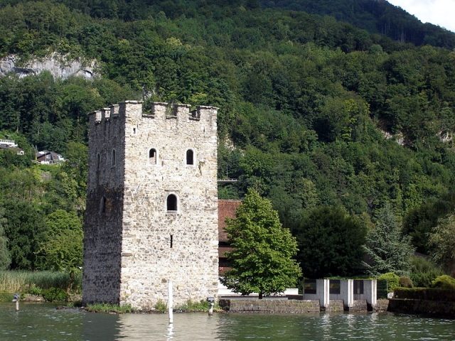
The Schnitzturm in Stansstad is a prominent part of a former medieval lakeside fortification on Lake Lucerne. It once served as a bulwark against threats from the lake and is today an important testament to the early Swiss Confederation.
History+
The extensive lakeside fortification near Stansstad, to which the Schnitzturm belonged, was completed in the 14th century. It was intended to protect the people of Unterwalden from attacks from Lucerne and from Neu-Habsburg Castle. After an attack by Lucerne warriors on Stansstad during the Battle of Morgarten around 1315, the defensive system was strengthened. This included three rows of wooden piles in the lake, a tower on an artificial island, as well as stone barricades, earthworks, and ditches on the shore. The Schnitzturm itself is only mentioned in documents in 1428, but was probably built around 1320. In 1589, the dilapidated tower was renovated and received its current round-arch windows and ground-level access. It was severely damaged by fire during an invasion by French troops in the 18th century but was later rebuilt and restored around 1880. Archaeological diving investigations in the 1970s uncovered underwater remains of the fortification, including palisades and a halberd iron from the early 14th century.
Location+
The Schnitzturm is located in Stansstad in the canton of Nidwalden, Switzerland, at an altitude of approx. 441 m above sea level. It is surrounded on three sides by the waters of Lake Lucerne and is connected to the shore only on its south side.
On site+
The Schnitzturm is currently not accessible to the public and cannot be visited.
Nearby+
- Rotzberg Ruin (Ennetmoos) (Castle), approx. 1.9 km away
- Rosenburg Castle (Höfli) (Stans) (Castle), approx. 3.3 km away
- Winkelried Castle (Stans) (Castle), approx. 3.9 km away
- Meggenhorn Castle (Meggen) (Castle), approx. 6.2 km away
Take Mobile History with you
You are reading this text for free. Premium adds what matters on the road: descriptions read aloud, sites found through your camera, whole regions taken offline.
- Every description, including the ~17,700 Premium sites
- Audio guide: have descriptions read to you on location
- AR finder: see sites through your camera, with distance and bearing
- Unlimited saved sites
14 days free, then from €2.99 a month. Cancel anytime.
Source: Wikipedia · Licence: CC BY-SA 4.0
This description draws on the facts documented in the linked Wikipedia article; Wikipedia content is licensed under CC BY-SA 4.0. Wording and editing: Mobile History.
Location: 46.9809, 8.3376