The remains of the Castle can be visited
Restaurant
CastleHerrenberg
Herrenberg Castle
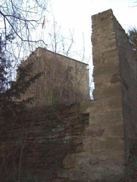
Herrenberg Castle was located in Herrenberg in today's Böblingen district in Baden-Württemberg.
What remains are ruins, a new observation tower built on an original tower stump with a deep dungeon, and remnants of walls, as well as a cellar of the former manor house, which was incorporated into a restaurant in 1957. Remains of the western outer bailey system are also preserved. Individual descriptions, six small drawings, cross-sections and engravings, as well as paintings, an imprecise fortress plan, and the cadastral map have survived to the present day.
In Herrenberg, the name probably comes from the directions "...am Graben unter meines Herren Berg" (at the ditch below my lord's mountain), the area around the mountain had long been inhabited. Hunters, Celts, Romans, and Alamanni have left various traces. The documented history of the Palatine castle begins in 1220 with the words "in castro nostro Herrenberc," which means "in our castle Herrenberg." In this castle, Count Palatine Rudolf II documented an exchange of goods with a monastery on Lake Constance on March 28, 1228.
The Counts Palatine of Tübingen (Count Palatine Rudolf I and Rudolf II) carried out a political and economic measure. The Alamannic settlements of Reistingen and Mühlhausen in the Ammer valley were quickly relocated to the western slope of Herrenberg. This place was laid out as a fortified city.
By making good use of the natural conditions, the fortress city of Herrenberg with its mountain castle was created on the western slope in a closed wall system.
In 1382, the property of the Palatine family was sold to Count Eberhard II of Württemberg. The old court was now under the administration of the High Bailiff of Württemberg. Count Ludwig I of Württemberg assigned it as a widow's residence for his wife Mechthild. Some time later, however, this was replaced. Mechthild had received her widow's residence in Böblingen Castle.
The castle, standing on the sandstone cap with the resulting subsidence and demolitions, repeatedly led to major damage. In 1470, a tower of the castle had to be removed due to massive problems.
At the end of the 17th century, the then Duke of Württemberg used Herrenberg Castle as a hunting lodge for wild boar and wolf hunts in the Schönbuch forest. Years later, the mountain became too arduous for the lord, so he chose his residence in the bailiwick.
The castle, along with the collegiate church and the deanery, also survived the city fire in 1635 as the only buildings. In the years after the fire, the castle no longer served as the official residence of the high bailiffs, who now conducted their business in the bailiwick's office building. Thus, only the castle guards occupied the castle.
During an earthquake in 1733, not only the collegiate church below suffered from the tremor, but the castle also sank by half a meter. The landslide caused great damage in the market square and in the residents' houses, which made the residents lose interest in the now dilapidated property. The princes also did not want to carry out any renovations. The first Württemberg king, Friedrich, finally sold the castle for demolition in 1807. Several citizens from the city and the surrounding area were interested. The demolition was compensated with the value of the stones recovered, and an additional 135 guilders had to be paid.
In February 1819, the Hofkameralamt sold the castle site for 100 guilders. For a time, city mayor Kayser in Stuttgart was also the owner of the area, who in the second half of 1837 sold the entire area to Carl Ludwig Ruthardt, the brother of the previous owner. In 1841, oaks and linden trees were planted on the "Kanonenbuckel" (cannon hill) for the 25th anniversary of King Wilhelm I's reign. The remaining ruins with the entire area were sold to the city of Herrenberg for 500 guilders in 1865.
In 1880, the broken tower stump was repaired and converted into an observation tower, repaired again in 1896, and a year later a panoramic map with a view of the Swabian Alb by J. Kleinfelder was mounted on the parapet. In 1912, neo-Gothic gates were installed in the castle walls.
In 1945, severe damage was caused to the ruin by bomb hits and artillery shelling. In 1957, the reconstruction of the western tower was initiated by the population with a large fundraising campaign, which was completed two years later. The Schlosskeller restaurant was also built.
Design of the Castle+
The castle itself, with its individual buildings in the main area, is arranged on a plateau almost in the oval of the mountain spur. Only an eight-meter difference in height can be observed in the complex, which had to be overcome between the gate threshold of the outer bailey in the west, via a flight of steps and a small courtyard near the western tower, to the large courtyard. The size of the complex is not particularly large. In an east-west direction, the main castle in the compound of shield and ring wall measures around 64 meters, in a north-south direction it measures 36 meters. The entire complex with outer bailey and bastion measures approximately 92 meters in an east-west direction, and only 44 meters in a north-south direction.
The stones for the construction came from nearby quarries and the timber was sourced from what later became the city forest.
The Castle Complex Today+
Observation Tower
The Schlossberg observation tower, which stands on the stump of the former powder tower, was built in 1957 by citizens of Herrenberg. From it, one can look out over the entire city and other communities. The round-walled dungeon is still located in this deep part of the mountain.
Schlosskeller Restaurant
Part of the old cellar has been prepared for the restaurant of the same name, Schlosskeller. Thus, cyclists, hikers, and walkers have a restaurant with a magnificent view on the edge of the Schönbuch forest at their disposal. A separate room can be rented for events on the Schlossberg.
Take Mobile History with you
You are reading this text for free. Premium adds what matters on the road: descriptions read aloud, sites found through your camera, whole regions taken offline.
- Every description, including the ~17,700 Premium sites
- Audio guide: have descriptions read to you on location
- AR finder: see sites through your camera, with distance and bearing
- Unlimited saved sites
14 days free, then from €2.99 a month. Cancel anytime.
Source: Wikipedia · Licence: CC BY-SA 4.0 · Image: http://schloesserrundschau.de/bawue/schloesser/herrenberg.html
This description draws on the facts documented in the linked Wikipedia article; Wikipedia content is licensed under CC BY-SA 4.0. Wording and editing: Mobile History.
Location: 48.5978, 8.8737