To be privately owned
CastleRees-Empel
Empel Castle
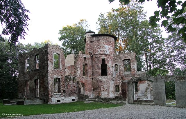
Haus Empel is the ruin of a moated castle in Empel, a district of Rees in the North Rhine-Westphalian district of Kleve. It is located in a nature reserve directly on the Empeler Meer, an old arm of the Rhine, and is surrounded by moats. The unsecured ruin is privately owned and not publicly accessible, but in 2007 it served as a backdrop for the television film Das Gelübde by Dominik Graf.
Haus Empel is first mentioned in a document in 1240 as the property of the knight Bernard von Rees. In a document from 1256, the estate of Emple is named and was expanded into a castle in the 13th and 14th centuries. Meanwhile, having come as an allod to the Lords of Hönnepel, a castle chapel is mentioned for Empel for the first time in 1339, when Lutzo von Hönnepel and his wife Lisa bequeathed a foundation to the chapel there. In an inheritance dispute on August 4, 1345, Rütger von Hönnepel received "the castle ter Empel and all goods within ter Empelt" before his seven siblings. This Rütger was for a long time in dispute with Walram von Jülich, the Archbishop of Cologne, which was to sustainably influence the status of Empel. Through the mediation of Count Dietrich VII of Kleve, a contract was concluded between the two warring parties on May 21, 1347, according to which Empel was henceforth to be a Cologne fief. In a document from 1349, Rütger also declared Empel to be an open house of Cologne. Nevertheless, conflicts continued, as Haus Empel was subsequently besieged by archiepiscopal troops. In a reconciliation treaty of October 18, 1356, Rütger von Hönnepel had to again pledge his property to the Cologne archdiocese as a fief and open house. He was also forbidden to further fortify Haus Empel without the archbishop's consent. Rütger's son Luysse succeeded his father as owner and was the first member of his family to call himself "von Empel". In 1387, the castle was besieged by troops from the Kleve city of Wesel, with the besiegers reportedly already having used a stone cannon.
Through the pledging of the office of Aspel/Rees to the Dukes of Kleve, Haus Empel had been a Kleve fief since the beginning of the 15th century. From 1482, the estate was for some years in the possession of the von Wittenhorst family, before it came in 1487 to Heinrich von Diepenbrock, who had married Sara, the daughter of a Rütger von Hönnepel and his wife Elisabeth von Hetterscheid. But already in 1489, Johann, a member of the von Hönnepel family, was again enfeoffed with Haus Empel. In 1491, he transferred it to the knight Johann von Wylich, the Kleve bailiff in the Hetter, who also owned Hueth Castle near Bienen. Johann von Wylich sold the Empel castle complex again in 1498 to Sara von Hönnepel and her son Rütger von Diepenbrock. The von Diepenbrock family had the medieval core castle of the complex redesigned in the Renaissance style in 1570. During the Eighty Years' War, the house was conquered and plundered by Spanish troops in 1598. The outer bailey burned down in the process. Under Baron Johann Hermann von Diepenbrock, Empel was elevated in 1661, together with the village of Hurl and the parish of Millingen, to a lordship with its own jurisdiction of Empel. Around 1700, the complex underwent a baroque redesign in the outer bailey area. In 1731, the Imperial Count Friedrich von Gronsfeld-Diepenbrock was enfeoffed with Empel. He or his heirs were forced to sell the indebted estate around the middle of the 18th century to Christoph Ludwig von Seckendorf. Further changes of ownership quickly followed. From 1765 to 1804, Empel was in the possession of the von Oppeln family and came in 1830 to the von Weiler family. Under them, Haus Empel was no longer listed in the registers of the knightly estates eligible for the Landtag. In 1923, Alfons Böck became the owner through inheritance.
In 1945, the buildings were completely destroyed during the fighting for Rees and not rebuilt. The ruin was entered into the monument list of the city of Rees in 1983 as an archaeological monument and in 2002 as a building monument. With the purchase of the ruin by Peter Landers in 2000, initial securing works began. On the initiative of the Millingen-Empel local history association, further securing measures were initiated in 2010 to preserve the existing building fabric. The costs for this are estimated at 120,000 euros and are to be borne by the state, the city of Rees, as well as the owner and the local history association.
Description+
The remains of Haus Empel stand on an island in the shape of a slightly distorted rectangle. To the southeast of it lies a square area surrounded by moats, which is divided into two equally large halves by a path in the middle. This is in all probability the remains of a baroque garden. Access to the castle island is provided by a wrought-iron gate on the southwestern side, which is delimited over half its length by a parapet-like, curved wall. The gate is flanked by two rusticated gate pillars with the Latin numerals MDCC (1700), on which Minervas formerly sat. On the wall once stood busts of Roman emperors. The portal and boundary wall date from a baroque redesign around 1700.
The northern part of the castle island was formerly occupied by the core castle, which was separated from the southern outer bailey area by a moat. However, this moat was filled in by the 18th century at the latest. Remains of the formerly three-winged main castle with slate roofs, specifically parts of the east wing and a round tower projecting into the moat, are still preserved, both of which were built around 1500. The east wing had an ornamented show bay window added in 1570, whose three window axes were framed by fluted pilasters. It had a shell-shaped top, supported by two fauns, and the inscription: ANNO DOMINI 1570. LIBET DOT DEINEN HERN UBER ALLES. UND DEINEN NEHESTEN ALSDICH SELBST. The curved console stones of the bay window are still preserved today. Also preserved is part of the 18th-century northern outer bailey wing, which adjoins the round tower of the core castle, as well as a slender round tower built around 1500 with a kinked, polygonal helmet at the south corner of the outer bailey area. In its basement, loopholes for arquebuses have been preserved.
The square main tower of the complex, called the "Heidenturm" (Heathen Tower), was already demolished before 1826. The approximately 30-meter-high brick building had four stories, which rose above a square floor plan and had vaulted ceilings on the lowest three floors. Its uppermost floor was called the "Heidentempel" (Heathen Temple). According to legend, the tower had been built in Roman times, but during its demolition, a pile foundation came to light, identifying it as a 14th-century structure.
Take Mobile History with you
You are reading this text for free. Premium adds what matters on the road: descriptions read aloud, sites found through your camera, whole regions taken offline.
- Every description, including the ~17,700 Premium sites
- Audio guide: have descriptions read to you on location
- AR finder: see sites through your camera, with distance and bearing
- Unlimited saved sites
14 days free, then from €2.99 a month. Cancel anytime.
Source: Wikipedia · Licence: CC BY-SA 4.0 · Image: http://www.zeche.org/
This description draws on the facts documented in the linked Wikipedia article; Wikipedia content is licensed under CC BY-SA 4.0. Wording and editing: Mobile History.
Location: 51.7936, 6.4174