The remains of the Castle can be visited
CastleCastell
Castell Castle
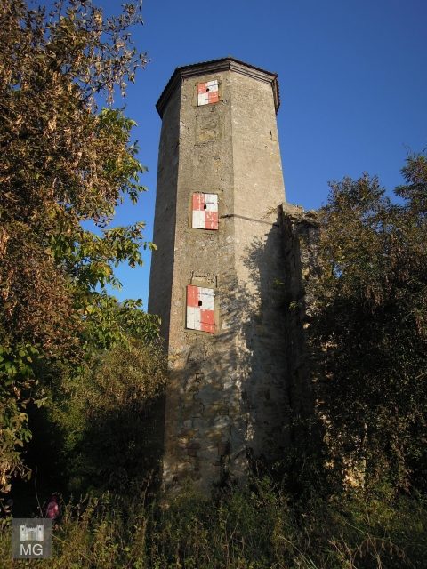
The castle ruin Oberschloss is located in Castell, Lower Franconia. In the early modern period, the so-called Upper Castle was built on the same site, of which some remains still exist today. Both fortifications, the castle and the palace, were the original ancestral seat of the Counts of Castell.
The former castle complex is located approximately 277 m from the parish church of St. Johannes in Castell. The preserved remains rise at the western end of a ridge running in an east-west direction, 394.41 m above sea level, known as the Herrenberg. The area where the castle site is located was called Schlossberg. The ruin can be reached from the village of Castell via several paths.
Further west, a hill rises in front of the preserved remains of the castle, representing the motte of the "Altcastell" fortification. The castle site itself is located at 396.6 m above sea level. It is thus only 2.19 m higher than the summit of the Herrenberg. The steep slopes of the mountain are now used for agriculture, so the castle site is surrounded by vineyards.
Oberschloss Castle was already the ancestral seat of the Counts of Castell in the 13th century. In the 16th century, the castle buildings were divided between two brothers of the family. After destruction in the German Peasants' War, the castle was rebuilt and a short time later fell victim to the Thirty Years' War. With the construction of the lower castle, the Counts moved their seat to the village and the upper castle fell into disrepair.
Early Mentions (until 15th Century)
The history of the castle is closely linked to that of the village and the lordship of Castell. The first mention of "Castel" in 816 already indicates a fortification in the village. It is probable that a castle complex already existed in prehistoric and early historical times, of which only a few section ditches remain today. Later, the complex was divided into two different castles.
While the predecessor of the lower castle, a circular castle, was expanded into a regional castle, the sources for the upper castle are silent in the 11th century. Only in 1258 do two castles appear in the village. They were the subject of a division treaty between Heinrich II and Hermann II of Castell. From then on, two Castellan houses existed in the village, their separation also recognizable by the different residences. Hermann inhabited the upper castle, Heinrich resided further down the mountain.
In 1265, the "castris Kastele" reappeared in the sources. Furthermore, the upper castle was mentioned again as "purg ze Kastel" in 1321. Meanwhile, in 1328, the lower castle was lost to the Burgraves of Nuremberg. Thus, the upper castle remained the only seat of the Castell family in the village. From then on, the sources also flow more abundantly: the castle is mentioned in 1342 and 1415, in connection with a brothers' feud.
Divisions (until 16th Century)
On December 4, 1453, the castle came under the influence of the Bishop of Würzburg. Wilhelm II of Castell agreed with Bishop Gottfried von Limpurg that the castle could not be sold in the next twenty years without the prince-bishop's consent. On February 28, the spiritual princes even took over the feudal lordship over the entire county, without affecting the comital status of the Castell family.
Wilhelm's son, Friedrich IX zu Castell, then gave half of the castle as a dowry to his wife Elsbeth, née von Reitzenstein. In the document about this event, the designation "slos Castel" appeared for the first time. The guard of tower keepers and watchmen was also reported. Around 1520, more precise information about the upper castle appeared: it possessed a stone Kemenate as its oldest element and was equipped with a Zwinger (outer bailey) and a well. Two towers were mentioned.
Again, in the 16th century, the castle area was divided. Johann II and Wolfgang I then resided together in the castle; even the chapel was used by mutual agreement. This was made possible by a so-called Burgfrieden (castle peace), which was drawn up as a contract at that time. This harmony was destroyed in 1525 when marauding peasant hordes plundered and burned down both castles in Castell during the German Peasants' War. In the upper castle, registers and documents were primarily destroyed.
Reconstruction and Renovation (until 17th Century)
The reconstruction began in Wolfgang zu Castell's part of the castle as early as 1525. At that time, the Kemenate was rebuilt. From August 10 to September 8 of the same year, the castle roof was covered. Johann II, on the other hand, took his time with his part of the castle and only started the reconstruction in 1528. By the end of 1530, the castle was largely restored, yet a clock was installed on one of the towers in 1545.
In the Second Margrave War of the 1550s, the castle's defenses were improved. In 1553, the walls were reinforced, and in 1554, the moats were deepened. For this, the areas previously occupied by the outer baileys were used. A poem mentions "Eight towers and walls." However, these figures were exaggerations, as the castle never had more than four towers. For further reconstruction measures, stones were taken from the ruinous lower castle in 1576.
At the beginning of the 17th century, a lot of construction took place again in the castle. In 1602/1603, the ovens were repaired and the windows mended, and in 1604, the castle received a new gatehouse. Furthermore, the main tower was raised; four towers on the building are documented from this year. A year later, a tower had to be demolished due to dilapidation. In 1606, the castle received a new corridor connecting the Kemenate with the bakehouse.
Between 1607 and 1615, the most extensive castle renovations took place. Again, stones from the ruins of the lower castle were used. In 1614, the planning of the octagonal stair tower began, which today represents the last preserved structural element of the Upper Castle. Johann Heinrich from Kitzingen was consulted for the design of the coats of arms on the tower. During the renovation work, the Counts stayed in their second castle in Remlingen, where they also experienced the outbreak of the Thirty Years' War.
Decline (until Today)
Shortly after the beginning of the war, the castle's fortifications were renewed in 1620. A year later, Count Gottfried had to entrench himself against passing Bavarian troops. In 1626, the construction of a defensive work began, but several passages of Schönborn and Saxon-Lauenburg troops delayed its completion. During this time, the Count increasingly stayed in the imperial city of Schweinfurt and neglected his own territory.
On November 14, 1634, enemy soldiers occupied the castle and the village of Castell. Salvation for the castle only came in 1637 when an imperial letter of protection was issued. However, the Counts now avoided their Upper Castle and preferred changing locations as residences. The castle was captured once more in 1640. A regiment of the Marquis de Grana caused great damage. By the end of the war, the castle was largely destroyed.
The Counts, whose new castle in the village was built by 1691, rarely visited the ruins of the Upper Castle thereafter. Only in 1646, 1652/1653 did they stay in the castle's rooms. Nevertheless, the worst destructions were provisionally repaired until 1680. The last gatekeeper of the Upper Castle is documented from 1738. By 1819, the last building remains on the Schlossberg disappeared; only the stair tower remained. The Bavarian State Office for Monument Protection classifies the remains of the castle as a monument under the number D-6-75-116-24.
Description+
The floor plan of the former fortification is still visible today. It was an oval structure, measuring up to 60 m in length and approximately 45 m in width. In the southeast of the area, three moats can be seen today, which probably belonged to two original outer baileys. The southwest is dominated by the 20.13 m high stair tower of the castle. North of the tower, a hollow can be recognized, which is attributable to the castle's original well.
Furthermore, several marginal embankments have been preserved, and traces of corner towers in the northeast and southeast can be surmised. Further north was another slope ditch, surrounded by an outer rampart. Even today, the width of the ditch remains is 8-11 m. In the outermost east of the complex, remains of a former bastion can also be seen. It was a round tower surrounded by a strong wall.
The only preserved element is the stair tower with a remnant of a wall. It is octagonal and has a tent roof. A spire and a finial were placed on top. The wall remnant reaches up to the lintel of the second upper tower floor. A bricked-up pointed arch window on it shows late Gothic tracery. Furthermore, another round arch window has been preserved. In the southeast, two embedded coat of arms stones can be seen. They show the alliance coats of arms of Wolfgang I von Castell and his wife Martha von Wertheim (bottom), and that of Friedrich Ludwig and the Princess of Hohenlohe-Langenburg (top).
The tower has a portal, which is surmounted by three beveled windows. The lowest one has been bricked up. In the uppermost floor, four longitudinally rectangular windows were also installed. Inside, the tower was built out in a round shape. A wooden spiral staircase leads upwards. The richly ornamented round arch portal with Ionic capitals and a profiled lintel cornice is crowned by a coat of arms tablet of Wolfgang II von Castell and his second wife Juliana von Hohenlohe.
Take Mobile History with you
You are reading this text for free. Premium adds what matters on the road: descriptions read aloud, sites found through your camera, whole regions taken offline.
- Every description, including the ~17,700 Premium sites
- Audio guide: have descriptions read to you on location
- AR finder: see sites through your camera, with distance and bearing
- Unlimited saved sites
14 days free, then from €2.99 a month. Cancel anytime.
Source: Wikipedia · Licence: CC BY-SA 4.0 · Image: Mobile Geschichte
This description draws on the facts documented in the linked Wikipedia article; Wikipedia content is licensed under CC BY-SA 4.0. Wording and editing: Mobile History.
Location: 49.7387, 10.3546