Hotel
Restaurant
CastleStaden
Ysenburg Castle (Staden)
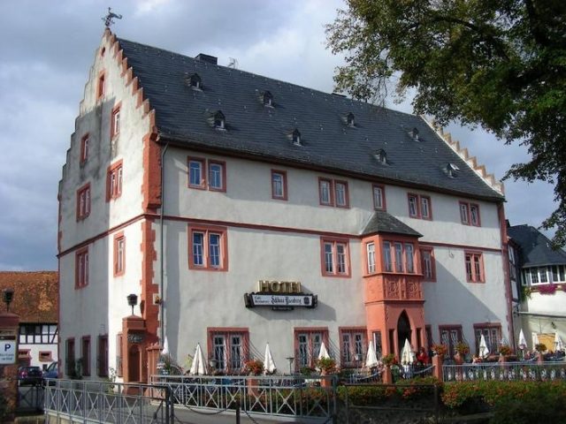
Staden Castle (also Ysenburg Castle) is a medieval moated castle of unknown social affiliation on the northern edge of Staden, municipality of Florstadt in the Wetteraukreis in Hesse.
The remains of the castle are located on a river island enclosed by the Nidda and a side arm later used as a mill stream for the castle mill located to the west. The location in the river lowlands necessitated its construction as a moated castle.
Not far from the castle grounds, the Upper Germanic-Rhaetian Limes runs past in a north-south direction. A small Roman fort (Kleinkastell Staden) was located at the opposite, southern end of the village.
First mentioned in 1156, when the nobleman Wortwin enfeoffed the castle to Fulda Abbey. The castle must therefore have been built shortly before its first mention, i.e. around the middle of the 12th century. Wortwin is possibly identical with an Ortwin mentioned in documents between 1133 and 1145, and thus a brother of Gerlach von Büdingen.
In 1233, the castle was owned by Gerlach von Büdingen and his relatives Heinrich and Gerlach von Isenburg (later Counts of Isenburg). With the extinction of the Lords of Büdingen, the complex remained with the Isenburg-Limburg line. Johann I von Limburg acquired town rights for the place in 1304 and had the Fulda fief renewed in 1308.
Johann II von Isenburg-Limburg sold the castle to several noble families in 1405. The joint inheritance was distributed among 19 co-heirs, who were included in the castle peace. Later, the castle was partly owned by the Burgraviate of Friedberg, the Löw zu Steinfurth family, and the Counts of Isenburg-Büdingen. The Löw von Steinfurth had a castle built outside the castle in 1746, the Löw'sche Schloss.
The co-heirs presumably had several manor houses built in the outer bailey area, of which only the Renaissance building, built in 1574 and now called Ysenburg Castle, has been preserved. The name is probably of more recent date, as the complex only came completely into the possession of Isenburg-Büdingen in 1788. The castle's fortifications were largely dilapidated or demolished by this time. The outer bailey area was leased from 1821, and finally managed as an agricultural estate from 1852.
Complex+
Main Castle
From the main castle located to the north, parts of the curtain wall are visible in the meadow area. Masonry made of bossed ashlar can be seen there. A wall tower was reconstructed as a transformer station.
Ysenburg Castle
The outer bailey is now occupied by a manor house, whose access road is located between the preserved gate tower and the castle building in the form of a bridge over the Nidda. The so-called Ysenburg Castle consists of a three-story stone building with stepped gables or crow-stepped gables with small steps. The second upper floor is executed in plastered half-timbering. On the courtyard side there is a round stair tower and a portal with the coat of arms of the Lords of Carben and the Lords of Bellersheim. On the south side, a two-story extension serves as an entrance area, which is reached via a small footbridge. Since 1949, the building has housed a hotel and cafe.
Gate Tower
West of the current bridge over the river and the castle building, the mighty former gate tower has been preserved, although its pointed arch gate was walled up at a later date. The tower was originally designed in shell form, as evidenced by the later inserted rear wall, and was probably converted into a residential tower in the 16th century, which is also proven by the installation of a fireplace on the 1st upper floor. On the fourth upper floor, the tower has keyhole-shaped loopholes on three sides, and some additional slit-shaped ones on the outer and inner sides.
Source Text: Wikipedia
Take Mobile History with you
You are reading this text for free. Premium adds what matters on the road: descriptions read aloud, sites found through your camera, whole regions taken offline.
- Every description, including the ~17,700 Premium sites
- Audio guide: have descriptions read to you on location
- AR finder: see sites through your camera, with distance and bearing
- Unlimited saved sites
14 days free, then from €2.99 a month. Cancel anytime.
Source: Wikipedia · Licence: CC BY-SA 4.0
This description draws on the facts documented in the linked Wikipedia article; Wikipedia content is licensed under CC BY-SA 4.0. Wording and editing: Mobile History.
Location: 50.3320, 8.9109