Museum
District court
CastleWolmirstedt
Wolmirstedt Castle
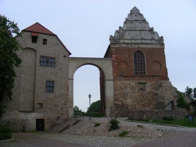
Wolmirstedt Castle (also Wolmirstedt Castle Estate or Wolmirstedt Fortress) is a medieval castle complex above the town of Wolmirstedt in Saxony-Anhalt.
The first documented mention of the castle dates back to 1009. At this time, the castle was likely an imperial castle and was enfeoffed to the Counts of Walbeck. In the 12th century, the complex belonged to the Margraves of Brandenburg. Ministeriales can be traced back to 1159. The castle, located at the then confluence of the Elbe and Ohre rivers, served to secure access to the Altmark to the north. This was particularly important during the frequent armed conflicts with the Archbishopric of Magdeburg to the south. Due to a changed course of the Elbe, the complex is no longer in the immediate vicinity of the Elbe today.
Under Margrave Albrecht II, the complex was enlarged in 1208 and now built of stone. In 1316, Margrave Waldemar had to sell the castle to the Archbishopric due to financial problems. From 1342, the castle served as the residence of the Archbishops of Magdeburg. In 1480, under Ernst II of Wettin, the castle was converted into a palace. From 1575 to 1585, Administrator Joachim Friedrich of Brandenburg had the complex extensively renovated and expanded.
During the Thirty Years' War, the castle complex was also damaged. The castle then stood empty for a time. From 1648, the outer bailey served as the economic court of the estate. In 1671, the so-called old house was demolished. The building was located in the northern part of the upper bailey and likely dated from the 13th century and the time of Albert the Bear. In 1702/1703, the keep was also demolished. This square tower, also from the Middle Ages, had been located in the center of the upper bailey. The former existence of the keep has not yet been archaeologically proven despite extensive excavation work.
From 1795, a court was located in the palas in the upper bailey. The judiciary still uses the building today. Further alterations took place at the end of the 18th century. The collegiate estate and the Junkerhof were merged. A large agricultural enterprise, Loß und Co., was established. At the end of the 19th century, the complex lost its function as a central economic court. The use of the palas as a courthouse continued. Until the end of the 20th century, the Wolmirstedt District Court was located there.
Complexes+
Upper Bailey
The upper bailey, located on an elevated position in the western part of the complex, was laid out in the Middle Ages on an irregular quadrilateral ground plan. The northeastern corner was probably removed in 1842 for the construction of a new barn in the lower bailey. On the north and west sides and in its center, the upper bailey is undeveloped today. Buildings originally existing here (such as the old house and the keep) were demolished over the course of history.
Palas
However, the palas, built of rubble stone, located on the south side of the upper bailey, has been preserved. The western part of the building is plastered. The roof is designed as a half-hipped roof. The main access to the building and the court is through an annex located on the courtyard side of the western part of the building. A shoulder arch portal leads to a spiral staircase from the Renaissance period.
Large cellar rooms are located beneath the palas. In the western part of the building, there are two cellar floors, each designed as a vault. The upper cellar has window slits to the castle courtyard and is designed as a two-aisled hall with a cross-ribbed vault. It was probably built at the same time as the castle chapel around 1480 in the Late Gothic style. The lower flat-barrel-vaulted cellar floor is windowless. The construction period is unknown.
Under the eastern part of the building, there is only one cellar floor, probably created during the Renaissance conversion, which is referred to as the "entrance hall".
The current building originated around 1480. It was built over the old moat as part of the castle expansion, so that the vaulted cellars are located in the old moat. According to dendrochronological measurements, the building was rebuilt in the years 1566 and 1575 in the Renaissance style.
After the Thirty Years' War, a conversion in the Baroque style took place. In 1702/03, the still existing Renaissance gable was demolished. In 1780, the uppermost floor was removed. A former walkway on the inner side of the castle on the upper floor is also no longer present today.
Castle Chapel
A castle chapel is first mentioned in a document in 1381. The current castle chapel was built in 1480. The chapel is built of brick. The hall is single-nave and comprises three bays. On the west side there is a rectangular projection. On its south side there is an inscription. A walled-up Romanesque portal can be seen in the east wall, above which a subsequently inserted founder's coat of arms is located. The coat of arms, dated 1480, is the coat of arms of Archbishop Ernst.
During the expansion of the castle between 1575 and 1583, and around 1630, the volute gables on the east and west sides were created. After 1765, damaged cross-ribbed vaults were demolished.
Lower Bailey
Tenant's House
In the lower bailey, located east of the upper bailey, the event center of the castle estate, now used as the "Katharinensaal", has been preserved. The building, erected in the Baroque style in 1773 and 1774, is two-story with eleven axes and a half-hipped roof.
Barn
The former barn has also been preserved. It is built of rubble stone.
Current Use+
Currently, the Wolmirstedt branch of the Haldensleben District Court is housed in the palas. The local history museum is now located in the former manor house of the collegiate estate.
Take Mobile History with you
You are reading this text for free. Premium adds what matters on the road: descriptions read aloud, sites found through your camera, whole regions taken offline.
- Every description, including the ~17,700 Premium sites
- Audio guide: have descriptions read to you on location
- AR finder: see sites through your camera, with distance and bearing
- Unlimited saved sites
14 days free, then from €2.99 a month. Cancel anytime.
Source: Wikipedia · Licence: CC BY-SA 4.0 · Image: http://www.wehrbauten.de/thread.php?threadid=893
This description draws on the facts documented in the linked Wikipedia article; Wikipedia content is licensed under CC BY-SA 4.0. Wording and editing: Mobile History.
Location: 52.2460, 11.6274