The Castle can be visited
CastleCalden
Wilhelmsthal Castle (Calden)
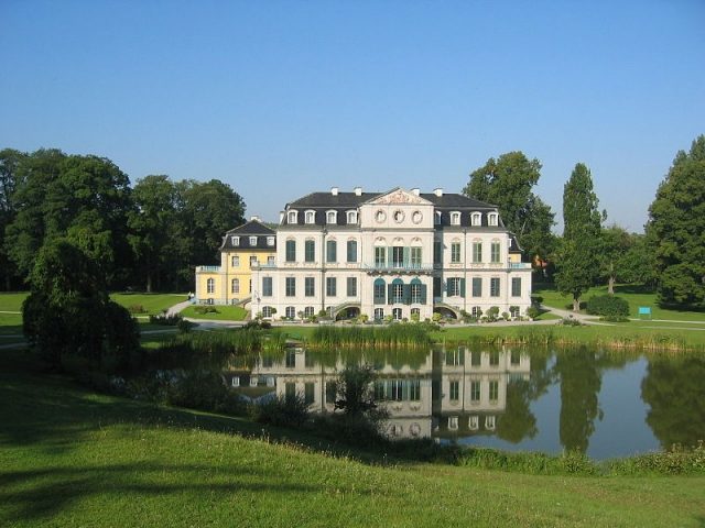
Wilhelmsthal Palace is a palace near the city of Kassel, near Calden in the northern Hessian district of Kassel (Germany). The complex was built from 1743 to 1761 and is one of the most important Rococo palaces north of the Main River. The palace has a large park with water features. The palace building can be visited as part of daily guided tours. The park – part of the European Garden Heritage Network since 2009 – is freely accessible all year round until dusk.
Wilhelmsthal Palace is located about 10 km northwest of Kassel city center and about 2 km south-southeast of Calden's town center. It is situated in the valley of the small Esse tributary Jungfernbach at approximately.
In 1643, the Hessian Landgravine Amalie Elisabeth, wife of Wilhelm V, bought the Amelgotzen estate. The estate was originally owned by Helmarshausen Monastery. Under the name Amalienthal, it served her as a modest country residence.
The current palace was built from 1743 to 1761 as a pleasure palace for the Hessian Landgrave Wilhelm VIII.
During the Seven Years' War, a bloody battle took place at the palace in 1762. Even today, a mass grave of about 4000 French soldiers is located in the palace park. This battle is taken up in the tale of the "Drummer of Wilhelmsthal," a teenage drummer of the Brunswick troops who, through a false drum signal, accidentally triggered the attack instead of the retreat, thus unexpectedly bringing about victory over the French troops.
Execution+
The palace was designed by François de Cuvilliés as a loosely arranged three-wing complex. The design of the facades already shows slight tendencies towards Classicism. Simon Louis du Ry only took over the construction management in 1756. The guardhouses in front of the palace are his work.
The designs for the interior also go back to Cuvilliés. The sculptor Johann August Nahl (the Elder) created the precious wall paneling and many stucco works. Not all of the rooms, which were originally executed in pure Rococo, have survived. Many furnishings come from Wilhelmshöhe Palace.
Particularly noteworthy is the so-called Gallery of Beauties with numerous portraits by Johann Heinrich Tischbein the Elder.
The chapel in the north wing is used by the Protestant community and the Calden registry office. Some rooms of the palace serve as a museum and event venue.
Palace Park+
Contrary to usual landscape arrangements, the palace is located at the lowest point of the park. The garden was planned as a fan-shaped three-axis system and is itself embedded in a larger landscape composition, which is concluded in the west and east by a lime tree rondel each. The central axis was intended as a water-bearing cascade, which flowed into the palace basin, originally framed in strict Baroque symmetry. The execution was partially implemented. Due to the Seven Years' War, work came to a standstill. Around 1800, the park was further developed into a landscape park with loose woodland, the basin was adapted to a naturally formed pond in the greenery, and the cascades were filled in. A Gothicizing observation tower was built from the stones of the cascades of the central axis.
In an elongated hill on the north axis is the former ice cellar, where ice was stored in the winter months to serve as cold storage in the summer. From the initial phase, only the grotto, which is the showpiece of the south axis, remains today. It was created by the sculptor Peter Laporterie, who richly decorated it with shells and glass. Originally, gilded putti were placed throughout the park. The sculptures, consisting of lead cladding and rosin wax fillings, suffer from changes in weather, so that now only the best-preserved ones adorn the balustrade of the grotto. The canal with the water features in front of the grotto as part of the south axis was only reconstructed after the Second World War. In the eastern extension of the south axis, directly behind the grotto, lies the (overgrown) water reservoir of the water features. Further east is the duck pond with the duck island built from roughly broken rocks. The duck house, built in a Chinese-like style on the duck island, is no longer preserved.
Take Mobile History with you
You are reading this text for free. Premium adds what matters on the road: descriptions read aloud, sites found through your camera, whole regions taken offline.
- Every description, including the ~17,700 Premium sites
- Audio guide: have descriptions read to you on location
- AR finder: see sites through your camera, with distance and bearing
- Unlimited saved sites
14 days free, then from €2.99 a month. Cancel anytime.
Source: Wikipedia · Licence: CC BY-SA 4.0
This description draws on the facts documented in the linked Wikipedia article; Wikipedia content is licensed under CC BY-SA 4.0. Wording and editing: Mobile History.
Location: 51.3930, 9.4158