To be privately owned
CastleErdweg - Unterweikertshofen
Unterweikertshofen Castle
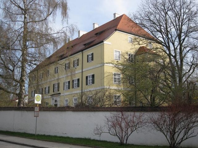
Unterweikertshofen Castle is a historic building in the municipality of Erdweg in the Dachau district, Bavaria. Originally built as a castle in the 12th century, it evolved into an important Hofmark castle that shapes the village of Unterweikertshofen and boasts a rich history.
History+
The origins of the castle date back to the 12th century when Weikertshofen Castle was founded by a noble family of the same name. In the 14th century, the Bavarian dukes expanded the complex into a strategically important stronghold. After numerous disputes over territorial affiliation in the 15th century, which referred to the structure as a “Veste”, the complex around 1550 consisted of three massive square towers connected by walls and buildings. After falling into disrepair in 1597, the foundation stone for a new castle was laid in 1610 by Sebastian Adlzhauser, completed in 1616. Just 17 years later, in 1633, the castle was destroyed and plundered by Swedish troops during the Thirty Years' War. By 1657, the castle was restored, presumably with four onion-domed corner turrets.
Location+
Unterweikertshofen Castle is located in the village of Unterweikertshofen, part of the municipality of Erdweg in the Dachau district, Bavaria, Germany. It stands at an elevation of approximately 488 meters above sea level.
On site+
Today, Unterweikertshofen Castle is privately owned and therefore not publicly accessible. Visitors can view the imposing structure from the outside, which continues to be a defining feature of the village landscape.
Nearby+
- Hof Castle (Castle), approx. 3.4 km away
- Sulzemoos Castle (Castle), approx. 4.9 km away
- Odelzhausen Castle (Castle), approx. 5.7 km away
- Altomünster Monastery (Sacred building), approx. 6.4 km away
Take Mobile History with you
You are reading this text for free. Premium adds what matters on the road: descriptions read aloud, sites found through your camera, whole regions taken offline.
- Every description, including the ~17,700 Premium sites
- Audio guide: have descriptions read to you on location
- AR finder: see sites through your camera, with distance and bearing
- Unlimited saved sites
14 days free, then from €2.99 a month. Cancel anytime.
Source: Wikipedia · Licence: CC BY-SA 4.0 · Image: hubi1802
This description draws on the facts documented in the linked Wikipedia article; Wikipedia content is licensed under CC BY-SA 4.0. Wording and editing: Mobile History.
Location: 48.3320, 11.2742