Forest Research Institute of the State of Rhineland-Palatinate
CastleTrippstadt
Trippstadt Castle
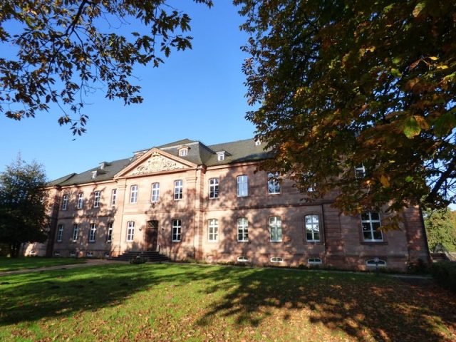
Trippstadt House (German: Trippstadter Schloss) is an 18th-century, baroque schloss or manor house in the eponymous village in the German state of Rhineland-Palatinate.
The building is made of red sandstone and comprises a single wing and is 48 metres long by 19 metres wide and 18 metres high. It has one basement and two storeys. Above the entrance is a relief of the coat of arms of the Hacke and Sturmfeder alliance.
The house was built in 1767 by the architect, Sigmund Jacob Haeckher, and called Maison de la Campagne ("Country House"). It was designed with a French garden. Its owner was Franz Karl Freiherr von Hacke and his wife, Amönia Freiin von Sturmfeder. He was the master hunter (Obristjägermeister) of Electoral Palatine, responsible for hunting in the 55 km² Barony of Wilenstein. The first lightning conductor in the Palatinate was installed at the house on 17 April 1776 by physicist, Johann Jakob Hemmer, from Mannheim.
French Revolutionary troops partly destroyed the house on 13 July 1794, leaving only the cellars inhabitable. The house went into Alsatian possession in 1803. The entire manorial estate of Trippstadt, including the house, was sold in 1833 by Reichsrat, Ludwig von Gienanth.
In 1865, the Freiherr von Gienanth sold the house to the Kingdom of Bavaria. They established a state forestry office there in 1885 and, in 1888, rebuilt the ruined part of the house. A forestry school was opened in the house. In 1915, during the First World War, the school had to be closed. Not until 1946, after the Second World War, was it re-opened as a school of forestry for the Palatinate.
The house was home to the Rhineland-Palatinate State School of Forestry from 1960 to 1980. In 1985, the municipality of Trippstadt took over the management of the gardens and turned them into a recreation area. In 1987, the house became the home of the Forest Research Institute of the state of Rhineland-Palatinate.
Take Mobile History with you
You are reading this text for free. Premium adds what matters on the road: descriptions read aloud, sites found through your camera, whole regions taken offline.
- Every description, including the ~17,700 Premium sites
- Audio guide: have descriptions read to you on location
- AR finder: see sites through your camera, with distance and bearing
- Unlimited saved sites
14 days free, then from €2.99 a month. Cancel anytime.
Source: Wikipedia · Licence: CC BY-SA 4.0 · Image: http://www.wehrbauten.de/thread.php?threadid=1326
This description draws on the facts documented in the linked Wikipedia article; Wikipedia content is licensed under CC BY-SA 4.0. Wording and editing: Mobile History.
Location: 49.3540, 7.7679