School
CastleStraupitz
Straupitz Castle
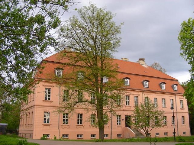
Straupitz Castle (also Straupitz Manor House) is a manor house in the Spreewald village of Straupitz in Brandenburg. Today it serves as a school building for a comprehensive school.
Originally, a moated castle surrounded by a six to eight meter wide moat stood here. From 1655, the von Houwald family owned the Straupitz manorial estate. The current castle was built between 1795 and 1798 under Carl Gottlob Willibald von Houwald in the Late Baroque style on the site of a previously existing Renaissance castle. The plastered building is simply designed, plastered, and covered by a mansard hip roof. The facade has 13 axes and is structured by a flat central risalit and corner risalits. From 1820, a wooden water pipeline from Pintschen's Spring supplied fresh water to the castle, which may have been used in the castle brewery.
In 1945, after the end of World War II, the von Houwald family was dispossessed and expelled by the communists. Since 1947, a school has been housed in the castle. A redesign in the style of emerging modernism took place after 1884 by Ernst Otto Graf von Houwald. With the assumption of lordship by his son Christoph-Heinrich von Houwald in 1903, many of these changes were reversed. An originally existing triangular gable was demolished in 1973. A restoration of the building took place from 1997 to 2002.
Tower Building+
Opposite the castle stands a simple, plastered brick building from the center of which a tower rises. The building was constructed in 1805. Its ground floor housed horse stables, storage rooms, coach houses, and an apartment. The upper floor housed the estate administration in addition to the inspector's apartment. The attic served as a grain store. The tower formerly had a clock on its front and was surrounded by a cast-iron railing. In summer, it was used as a fire watchtower until 1945. A modern device was acquired in the 1930s for locating fires. In the first half of the 1980s, the building was completely rebuilt and extended, and its exterior facade was significantly altered.
Granary+
Halfway between the castle building and the village church of Straupitz, which stands outside the castle grounds, is the granary, built around 1798. The right side of the building, where the massive walls extend up to the upper floor, was used as an ice cellar in the past. Ice was broken on Straupitz Lake in winter and transported by carts to the ice cellar. Grain, flax, buckwheat, and millet were stored on the upper floors. Its function as a granary continued until 1992. An extensive renovation began on September 1, 2004. The reopening was celebrated on September 24, 2005. The granary now houses an exhibition on the history of Straupitz, a pottery workshop, and a small restaurant. In January 2005, the "Freundeskreis Kornspeicher e.V." (Friends of the Granary Association) was founded, dedicated to the preservation and maintenance of the building. A section of the historic water pipeline leading from Pintschen's Spring to the castle is also exhibited in the granary.
Villa+
To the left of the access road to the castle grounds is the so-called Villa, built in 1886 as the widow's residence of the von Houwald family. Until then, the "New House" stood in its place. This two-story building with a mansard hip roof, erected in the 18th century, also served as a widow's residence and had become dilapidated. The small tower of the Villa was shortened by its slate-covered spire during a renovation. Today, the building houses doctor's and dentist's practices.
Obelisks and Castle Park+
The access road to the castle grounds is marked by two approximately 10-meter-high obelisks. Both were renovated in 1996. Their erection date is currently unknown.
The castle park was created around 1900 on former pastureland, modeled after English landscape parks. It is characterized by a system of paths, small lakes, streams, large trees, and open meadows, and extends over 12 hectares. The tree population was gathered from different parts of the world. In the 1950s, a sports field was laid out on its central open space.
Take Mobile History with you
You are reading this text for free. Premium adds what matters on the road: descriptions read aloud, sites found through your camera, whole regions taken offline.
- Every description, including the ~17,700 Premium sites
- Audio guide: have descriptions read to you on location
- AR finder: see sites through your camera, with distance and bearing
- Unlimited saved sites
14 days free, then from €2.99 a month. Cancel anytime.
Source: Wikipedia · Licence: CC BY-SA 4.0 · Image: http://www.wehrbauten.de/thread.php?threadid=527
This description draws on the facts documented in the linked Wikipedia article; Wikipedia content is licensed under CC BY-SA 4.0. Wording and editing: Mobile History.
Location: 51.9085, 14.1180