To be privately owned
CastlePlausdorf
Plausdorf Castle
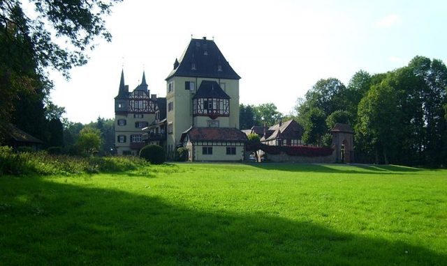
Plausdorf Castle is a country estate on the northeastern edge of the Amöneburg district in the greater municipality of Amöneburg, Marburg-Biedenkopf district, Hesse. The castle-like complex consists of a manor house and a water mill from the 16th century, as well as numerous extensions made at the beginning of the 20th century, and is surrounded to the southwest to southeast by a park covering a good five hectares. To the northwest, it is flowed through by the lower course of the Klein, from which a mill race flows through the estate.
Plausdorf Castle is located on the outermost edge of the Amöneburg district, directly on the border with the town of Kirchhain to the north and about 600 meters from the border with Stadtallendorf to the east, whose Ferrero settlement begins 1.2 kilometers to the east. It adjoins the Brückerwald directly to the north, which is segmented by the B 62 at a distance of 100 meters from the park and 300 meters from the castle. The Stadtallendorf district of Niederklein begins 2.5 kilometers to the southeast, the settlement area of the core town of Amöneburg three kilometers to the southwest, and that of Kirchhain two kilometers to the northwest.
The mill and farm were first mentioned in 1463, but the current mill probably dates from the mid-16th century. In 1565, the manor house was built in Renaissance style. In 1571, Mainz enfeoffed Konrad von Schwalbach with the estate, who, documented by the number 1583 on the building, carried out significant extensions.
In 1618, the farm was sold by the von Schwalbach family to Melchior von Lehrbach. In 1701 and 1728, the border between Mainz and Hesse ran directly through the estate, with the manor house located on the Mainz side. In 1756, the farm was entirely on Mainz territory.
In 1899, the von Goldammer family acquired the farm and had it, partly from ruins, expanded into a country manor in the Historicist style between 1901 and 1914. With the dissolution of the estate districts in Prussia in 1928, Plausdorf Castle was finally incorporated into Amöneburg.
Structure+
The main building line extends for 130 meters to the east-northeast; from the southwest, a second line extends to the northeast, forming an asymmetrically oval U-shape.
At the very east lies the 28-meter-long complex around the east tower, to which the 37-meter-long manor house adjoins. After a six-meter gap, a 28-meter-long outbuilding follows, separated by only a few meters from the 13-meter square main house of the mill. To the northeast of the mill, also after only a very small gap, a three-part outbuilding adjoins in a slight curve.
The following pictures show, from west to east, views of the south side:
Access+
The castle is privately owned and cannot be entered.
South of the castle, at a distance of exactly 100 meters, runs a publicly accessible forest path which, especially in winter, offers a view through an open fence. From the east, the publicly accessible water protection area extends to within ten meters of the castle buildings; on the north side, the other bank of the Klein on the Kirchhain side is about 20 meters from the buildings.
Take Mobile History with you
You are reading this text for free. Premium adds what matters on the road: descriptions read aloud, sites found through your camera, whole regions taken offline.
- Every description, including the ~17,700 Premium sites
- Audio guide: have descriptions read to you on location
- AR finder: see sites through your camera, with distance and bearing
- Unlimited saved sites
14 days free, then from €2.99 a month. Cancel anytime.
Source: Wikipedia · Licence: CC BY-SA 4.0
This description draws on the facts documented in the linked Wikipedia article; Wikipedia content is licensed under CC BY-SA 4.0. Wording and editing: Mobile History.
Location: 50.8127, 8.9670