Museum
Local government
Restaurant
CastlePhilippsthal
Philippsthal Castle
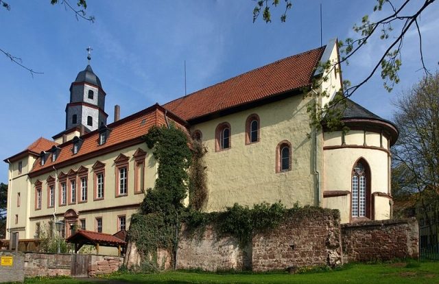
Philippsthal Castle is located in the lower Werra valley, in the Hessian municipality of Philippsthal. The baroque residence of the Landgraves of Hesse-Philippsthal was built from 1685 to 1735, on the basis of the Hersfeld monastery of Kreuzberg, which was dissolved in the course of the Reformation.
The castle has three wings that are grouped around a trapezoidal inner courtyard. The courtyard narrows towards the east and is open in that direction.
The west wing is about 120 meters long and borders the castle complex to the old village center located to the west. Among other things, the Landgrave's library was housed here. Today, the municipal library is located in these rooms. In the middle of this two-story (further south also three-story) wing is a representative sandstone gate, with the coat of arms of the Landgraviate of Hesse-Kassel in the gable field.
The north wing runs southeast, along Schlossstraße, towards the archway house. This wing burned down in 1976. Subsequently, a new tract was built on its foundations to preserve the character of the three-wing complex. Today, several retail stores and a retirement home are located there.
The archway house in the east was the representative main entrance to the castle, as only about 1.5 kilometers upstream, via the old Werra bridge Vacha, the busy trade route Via Regia between Frankfurt and Leipzig passed by. The archway house with its mansard roof was built in 1734. Until 1998, it housed an information point of the border customs service. Afterwards, the Border Museum was housed here.
The main building was the three-story south wing. Today, it houses the town hall of the market municipality of Philippsthal. The building extends about 50 meters to the east, where it leans against the northern aisle of the former monastery church. The tract originated from the Kemenate, the provost's house, which was architecturally adapted and extended to the east. Already around 1590, the southern aisle had been separated from the church and used as a storage room for the agricultural operation, which managed the monastery's property from about 1560, when the last nuns had left the monastery. This separated aisle was then converted into representative rooms during the castle construction period. Among other things, there were also two rooms for the princely family, who could follow the church service from here.
The monastery church originally had a westwork with two flanking towers. However, it is not certain whether the two towers ever stood at full height. Both towers, with a square base, were shortened to the height of the castle buildings and serve as stairwells or connections between the south wing and the rooms on the south side of the church. Since then, the church has a central bell tower in the west. In 1733, the original main entrance in the west was walled up, as the family crypt was built below the bell tower in that year. Katharine Christine of Saxony-Eisenach (1699-1743), wife of Landgrave Karl I of Hesse-Philippsthal (1682-1770), was buried here in 1743 as the first Landgravine of the Philippsthal line.
The trapezoidal castle courtyard has an area of about 4000 m². Beyond the southern castle wing or the church, the castle park extends down to the Werra. It has an area of about 50,000 m² and is almost completely surrounded by a man-high sandstone wall. In the upper part, at the castle, it is an ornamental and utility garden in the French style. The lower part extends from the orangery built in 1731 to the Werra. This area is designed in the form of an English landscape garden. Until 1905, the park also continued on the other side of the Werra; however, this park area was leveled due to the construction of the Ulstertalbahn.
Take Mobile History with you
You are reading this text for free. Premium adds what matters on the road: descriptions read aloud, sites found through your camera, whole regions taken offline.
- Every description, including the ~17,700 Premium sites
- Audio guide: have descriptions read to you on location
- AR finder: see sites through your camera, with distance and bearing
- Unlimited saved sites
14 days free, then from €2.99 a month. Cancel anytime.
Source: Wikipedia · Licence: CC BY-SA 4.0
This description draws on the facts documented in the linked Wikipedia article; Wikipedia content is licensed under CC BY-SA 4.0. Wording and editing: Mobile History.
Location: 50.8412, 10.0053