To be privately owned
CastleBodenfelde - Nienover
Nienover Castle
In 1144, Nienover Castle was first mentioned in the register of allods belonging to Count Siegfried of Northeim. This first documented mention of Nienuverre refers to the Romanesque castle complex.
The site is a mountain spur, where the structure offered imposing protection to the south. To the north, the terrain slopes away without a distinct transition, contrasting with the surrounding mountainous landscape of the Solling. As such locations are more typical for the Early Middle Ages than for the High Middle Ages, the construction of Nienover Castle is dated to the first millennium. From this period, when the area belonged to the Augau, a wall remnant with a window has been preserved, as well as a castle well approximately 33 meters deep and parts of the surrounding wall.
Later, the castle probably first came into the possession of Hermann II of Winzenburg, and after the outlawing of Henry the Lion, it became an escheated imperial fief of the Counts of Dassel, who moved their main residence there around 1200. In 1274, the Counts of Dassel offered to surrender it to the Welfs if the imperial fief were to be confiscated, but King Rudolf I did not agree. Therefore, the castle was only sold to Albrecht II in 1303. From here, the Dukes of Brunswick undertook hunting excursions into the Solling. Duke Heinrich Julius of Brunswick-Wolfenbüttel also regularly used the castle as a hunting residence. Duchess Elisabeth of Calenberg-Göttingen used it as a residence, and from 1540 as a widow's seat. The castle was destroyed in the Thirty Years' War.
Town
Location and Structure
On the land in front of the castle, the Counts of Dassel founded a settlement around 1180, which, due to its size and later documents, was a town. The complex was built as a three-street system leading towards the castle. The location was at a crossroads, from which roads led to Gieselwerder Castle, Dassel Castle, and via the old military road to the temporary royal camp near Sohlingen. The ground area on the ridge is formed as a plateau. The soil tends to be moist due to the geology of the Solling. Therefore, the houses had stone cellars, on which the buildings were constructed in a post-and-beam style.
To build the houses and for agricultural use of the land, the Counts of Dassel had clearings carried out. Since this was partly not covered by their rights, the Counts had to atone to Bishop Bernhard III in 1210.
The houses stood along the streets and up to the edge, so there were houses of different sizes, which is considered an indication of a socially structured population, unlike in a village. The former houses were about 17 meters long, the latter shorter, corresponding to the size of the plots in the town plan. Several shallow wells, similar to stone cisterns, were also present. Fragments of High Medieval pottery have been preserved as evidence of the inhabitants' activities and served to date the events.
Around 1220, Nienover probably fell victim to a fire as a result of a feud, but was immediately rebuilt.
On the north side, the town was secured by two earthen ramparts, separated by a ditch about 2.5 meters deep, which were approximately three meters high. From comparable medieval structures, research concludes that a palisade existed on the rampart. The total width of the defensive system was up to 40 meters.
Battle and Sale
At a time between 1269 and 1274, Nienover was attacked from the north. A battle occurred involving numerous crossbow bolts and arrows. The wooden construction proved to be a disadvantage, so the entire town burned down; only the castle remained usable in the following centuries. At the same time, the economic conditions had significantly worsened, as the protective counts withdrew from the southern surroundings by selling Schartenberg Castle. Therefore, the houses were not rebuilt.
The last person documented in the subsequent decades was the priest. There are no documents about the attackers; for power-political reasons, Albrecht the Tall is a possible mastermind.
On February 15, 1303, Count Simon of Dassel sold Nienover Castle and County, with associated rights and possessions, to Duke Albrecht the Fat as sovereign of the Principality of Göttingen. Thus, the place came into the possession of the Welfs.
Deserted Settlement
The destroyed town, after its desertion, was used as arable and pasture land without further construction. Its physical existence fell into oblivion, so it was only rediscovered through research starting in 1996. The desertion, despite its central European location, is a consequence of the change in High Medieval territorial rule and is fundamental to understanding the current southern borders of Lower Saxony.
In the ground, the town rampart, cellars, remnants of the streets of the three-street system, and other evidence of the medieval settlement of Nienover have been preserved. The complex is a rare example of a deserted town and thus an archaeological ground monument of international scientific and supra-regional tourist interest.
Partial Reconstruction
Over an excavated cellar of a house near the street, an urban half-timbered house from around 1230 has been reconstructed by a building historian on a scientific basis. In its basic structure, it incorporates elements of the hall house. Historical techniques appear to have been applied in the construction.
As it is the former baker's house, it is equipped with a stone oven, without a chimney as was typical for the time. It also has a large gate for the entry of the harvest cart. The attic is spacious. The roof is covered with wooden shingles. The cellar connects to the original. The property is enclosed by a wattle fence made of willows.
Castle (Schloss)
Building
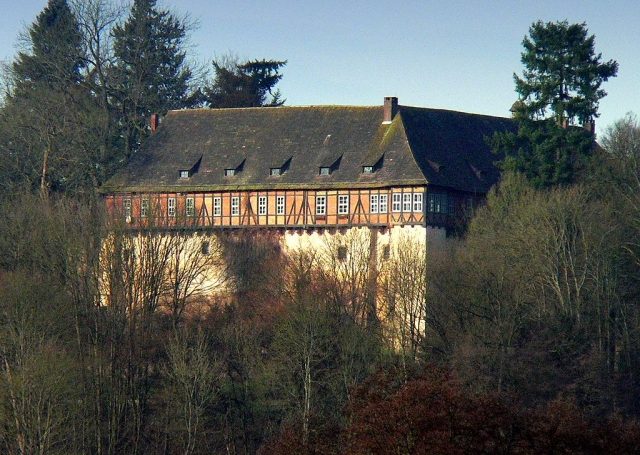
On the site of the destroyed castle, the present Schloss, with a half-timbered upper floor and a sandstone roof, was built between 1641 and 1656. The structure is divided into three construction phases, as the main building is divided into two halves by the visible central corner quoin construction joint, to which a modern annex was added. The furnishings included valuable wall paneling, which has since been consumed for heating purposes. A church is documented as an accessory in 1535. The castle garden covers three hectares.
Usage
In front of the Schloss, on the south side, there is a three-tiered terrace system from around 1690. It served as a kitchen garden for fruit and vegetables, with the heat-retaining dry stone walls counteracting the harsh climate of the Solling. Until 1962, the Schloss was the official residence of a forester. From 1964, it was in private ownership. In 1979, Prime Minister Ernst Albrecht bought it to use as a guesthouse for the Lower Saxony state government. The state government later had it structurally renovated. From 1984 to 2005, Nienover Schloss housed an outpost of the Faculty of Forestry of the Georg-August University of Göttingen. In November 2005, the Lower Saxony state government, under the leadership of Hartmut Möllring, sold the Schloss into private hands. It has since been the seat of a stud farm. The Schloss is surrounded by a modern wall and is not accessible to the public.
Landwehr (Defensive Line)
After the rampart system proved to be an unsuitable fortification, a Landwehr was erected approximately 200 meters north of the castle. The exact time is unknown. Johannes Krabbe sketched its location in his 1603 map of the Solling. Although a document exists regarding its elements, it is interpreted as a phrase, so a construction in the then-usual manner is assumed. An undulation of about 200 x 8 meters, running parallel to the B 241 to a wet depression, is interpreted as a remnant of the complex. Near Nienover, there are remnants of dams. In initial modern research, they were misinterpreted as parts of the Landwehr, by assuming that they, with the water thus dammed, would have flooded the military road for defense.
Outwork and Stud Farm
Below the Schloss, as remnants of an outwork, stand the stately, formerly water-powered mill, which can be visited; as well as the former official inn and a tithe barn. On the opposite slope, on the other side of the L551, stands the Wildenhaus, an 18th-century building that recalls the ducal stud farm that was located in Nienover from the 16th to the 18th century. The beginnings of horse breeding in the Solling date back to Erich and Elisabeth of Calenberg-Göttingen. The main building of the stud farm at that time stood where today the 18th-century Wildenhaus (meaning mare stable) stands on the slope east of the Schloss. In 1760, the stud farm was moved to Neuhaus im Solling. The founding of the new stud farm in 2005 continues the tradition of local horse breeding. Gaited horses are bred at the stud farm. The use of the area as pasture serves to maintain the historic cultural landscape.
Take Mobile History with you
You are reading this text for free. Premium adds what matters on the road: descriptions read aloud, sites found through your camera, whole regions taken offline.
- Every description, including the ~17,700 Premium sites
- Audio guide: have descriptions read to you on location
- AR finder: see sites through your camera, with distance and bearing
- Unlimited saved sites
14 days free, then from €2.99 a month. Cancel anytime.
Source: Wikipedia · Licence: CC BY-SA 4.0 · Image: https://commons.wikimedia.org/wiki/File:Nienover_Schloss.jpg
This description draws on the facts documented in the linked Wikipedia article; Wikipedia content is licensed under CC BY-SA 4.0. Wording and editing: Mobile History.
Location: 51.6808, 9.5229