Golf course
CastleKorschenbroich
Myllendonk Castle
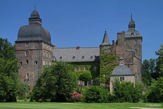
Myllendonk Castle is a moated castle located in Korschenbroich near the city limits of Mönchengladbach in the Herrenshoff district on the left Lower Rhine.
The Lords of Myllendonk, verifiable since 1166, held a significant position among the noble families of the Lower Rhine, which manifested in extensive possessions. The most famous son of the family to this day is the Benedictine abbot and later Cistercian monk Caesarius von Milendonk. His sister Irmintrudis von Mylendonk was abbess of the Benedictine convent of Dietkirchen near Bonn, to which she had been transferred from another monastery by the Archbishop of Cologne Philipp I von Heinsberg.
When the family died out at the end of the 13th century, Myllendonk passed to the Lords of Salm-Reifferscheid and around 1346, through marriage, to the von Mirlaer. The latter later named themselves von Myllendonk after their new ancestral seat.
From 1621, the castle was in the repeatedly changing possession of counts and dukes, most recently that of the Counts of Ostein. In 1700, the lordship of Myllendonk, which had been independent until the end of the 13th century, regained its imperial immediacy.
In 1794, the region was occupied by French revolutionary troops (First Coalition War). In 1803, Franz Gottfried von Maerckem bought the complex, which in 1832 passed through his niece to the family of the Barons von Wüllenweber, who have since inhabited and maintained the castle.
Building History+
Immediately on the eastern bank of the straightened Niers lies the extensive complex, surrounded by moats and subdivided multiple times. It is accessed by the entrance located to the east. Three bridges lead from the outer bailey to the inner bailey island, which was enfeoffed to Archbishop Engelbert I of Cologne in 1263/64, and finally to the main castle. Between this and the western outer moat lies a fourth castle island, which served entirely as an unbuilt kitchen garden.
Myllendonk, built on piles in the Niers floodplains, particularly impresses with its tall brick buildings, which appear rather randomly joined together and tower over the tree-lined landscape. Due to its nested silhouette, the castle corresponds to the picturesque-romantic image of a defiant moated castle.
A coat of arms stone dated 1559, which was moved to the renewed courtyard front of the west tower in 1856, indicates alterations and extensions. It possibly originated from the newly erected east wing, which also spanned the entrance.
When parts of the Gothic palas collapsed in 1591, its courtyard front was completely renewed and equipped with a decorative Renaissance loggia. All roofs and the lantern-crowned tower spires also date from the last decade of the 16th century. According to the dating of a wall anchor, the six-story northeast tower and the east facade of the side wing were transformed into a baroque show front in 1630.
The newly created splendor, which was rounded off by a baroque terraced garden with a small pavilion, did not last very long, however. In 1642, the castle was damaged during military conflicts. In 1655 and 1671, it was occupied by Spanish-Guelders troops, who were to prevent the desired secession from the feudal association. In this context, the arcaded passage was walled up, and in the mid-18th century, the southern part of the east wing, including the gate passage, was demolished. Nevertheless, an imposing complex has been preserved to this day.
Current Use+
Today, the area belonging to the castle features an 18-hole championship golf course. The facility is operated by the Myllendonk Golf Club. The club was founded in 1965 with nine holes and expanded to 18 holes in 1980. The course now offers a challenge for all skill levels. The fairways embedded in the castle park with old trees and the numerous water hazards require a well-thought-out playing strategy.
Take Mobile History with you
You are reading this text for free. Premium adds what matters on the road: descriptions read aloud, sites found through your camera, whole regions taken offline.
- Every description, including the ~17,700 Premium sites
- Audio guide: have descriptions read to you on location
- AR finder: see sites through your camera, with distance and bearing
- Unlimited saved sites
14 days free, then from €2.99 a month. Cancel anytime.
Source: Wikipedia · Licence: CC BY-SA 4.0 · Image: http://www.zeche.org/
This description draws on the facts documented in the linked Wikipedia article; Wikipedia content is licensed under CC BY-SA 4.0. Wording and editing: Mobile History.
Location: 51.2096, 6.4902