Museum
Theater
CastleMoers
Moers Castle
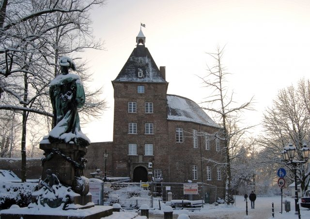
Moers Castle is the oldest known building in the city of Moers. Little is known today about the early past of the castle, as much information regarding its construction was lost during the great city fire in 1605. The castle is located between Kastellplatz and the city park, right in the center of Moers. Today, it houses the Grafschafter Museum and the City Theater.
Otto Ottsen wrote in his book The History of the City of Moers: "I consider the history of Moers Castle to be one of the least clarified chapters in the city's history." However, recent structural investigations by the Rhenish Office for Monument Preservation and excavations between 2000 and 2003 allow for some statements regarding its construction history.
Origin+
The first building of the castle was erected around 1200. It was a square tower made of tuff stone, a volcanic rock primarily found in the Eifel region. The material likely originated from the former Roman camp in Asciburgium. The side lengths of the massive Romanesque tower were about seven meters. No verifiable statement can be made about its height, as nothing of the tower remains today except for its foundations and ground floor. These remnants can be found in the castle courtyard, where they are preserved several meters deep in the ground.
It is assumed that the tower depicted in the Moers city coat of arms is a stylized representation of this first castle tower. Another theory suggests that the so-called Meerturm (a tower of the old Moers city wall) was the model for the coat of arms.
During the 13th century, the castle lords piled up a circular mound around the tower, which became necessary due to the marshy ground to allow for the construction of further buildings. The existing tower was probably demolished down to the ground floor and used for backfilling. This mound was surrounded from the outside by a ring wall, approximately 3 m thick and 12 m high, made of recycled Roman field bricks, presumably also from Asciburgium. The Moers ring wall castle is thus one of the oldest preserved brick structures in the Rhineland. Through later extensions, initially outwards (15th and 16th centuries) and later (19th century) inwards towards the castle courtyard, the ring wall in the preserved part of the building represents a central interior wall tapering floor by floor.
Development+
The oldest known depiction of the city and castle dates from 1580 and shows a presumably even older state of construction. The Moers riding master Arnold van Heurdt (1651–1705) redrew this plan in the 17th century. Only his drawing has survived; the original was lost. This depiction still shows the west wing of the ring wall castle as the main building of the medieval complex with north and south towers. The battlement visible between the towers today forms the corridor of the still existing building. To protect against cannonballs, the old castle was surrounded by curtain walls. These then served as foundations for the expansion of the castle outwards in the 15th/16th century. The so-called Palas, created between the curtain walls and the old ring wall, contains the spacious Knights' Hall. In the course of the expansion, the old north tower was demolished and the current tower in the entrance area was erected. The ring wall castle thus gradually became a perimeter house castle. It was now significantly more representative and comfortable and corresponded to the important status of the Counts of Moers in the 15th century.
A similar map by Johannes Mercator from 1591 exists. At that time, the castle already consisted of several elongated buildings built next to each other. These lean against each other in a square. However, most descriptions of the castle indicate a rounded (polygonal) building form. All buildings had a pointed roof and were covered with tiles. On closer inspection, one can already recognize the large tower with the small bell tower, as it still stands today.
The castle was surrounded by a moat, which in turn was surrounded by a defensive system consisting of ramparts, walls, and bastions. The structure, like the old and new towns located to the north, stood in the waters of the so-called "Meer," the dammed Moerse. There was only one bridge leading to the old town, which connected to a large gate in the north of the complex. The south tower and the castle chapel, which were still in existence at that time and were reported on as early as 1466, are difficult to discern.
After the city was taken by Maurice of Orange, he had the castle reinforced with five bastions between 1601 and 1604 for 100,000 guilders. The city of Moers was also fortified between 1610 and 1620 according to the Old Dutch system, which was developed during the Dutch Wars of Independence. Here, the aforementioned rounded shape of the castle is clearly visible.
The area, which previously had a square shape, was now fortified in a star shape. The moats around the castle can still be seen in their star shape today on an aerial photograph in the castle. However, they have since been partially rebuilt or built over. The old and new towns were combined into a single fortress. New moats were dug and new ramparts were piled up.
The next drawing dates from 1663. It shows Moers Castle and the city in plan. Moers was considered an "impregnable fortress" at that time, provided it was diligently defended by its inhabitants. The fortifications were razed in 1763 after the end of the Seven Years' War at the behest of Frederick II of Prussia – Moers had become Prussian in 1702. During this measure, the moat between the castle and the city was eliminated, and the existing Haagsche Bridge became superfluous. Some moats were filled, and the material needed for this was taken from the inner ramparts of the defensive system. The resulting garden land was partly sold in parcels, partly donated as church land. The castle was used as a royal administrative building.
In 1765, the castle was already in a rather dilapidated state and urgently needed renovation, but its basic structures were still largely preserved, as shown by the floor plan drawing by surveyor Arnold Brix from around 1800. In 1802, the castle was described as a "ruined building, standing windowless and only provided with the entrance door" (Otto Ottsen).
The eastern part of the castle was demolished, and a windmill and a residential house were to be built there. Due to problems with the ownership of the plots belonging to the castle purchase, it was resold in 1810. The textile entrepreneur Friedrich Wintgens, who was the most important entrepreneur in Moers at that time, bought it for 2,000 francs. He had previously converted the buildings located east of the castle (formerly accommodations for French and Dutch troops) into a residential house and factory. The inner fortifications were demolished, and the castle courtyard was planted with trees. Parts of the castle property were sold, and the remaining area was transformed into gardens and parklands by the new owner. Two- to three-story brick extensions were added to the inner courtyard side, along with a fundamentally altered window arrangement. In 1836, Wintgens had the wilderness, crisscrossed by moats, converted into the current castle park.
In 1905, the city of Moers acquired the castle at the instigation of Dr. Hermann Boschheidgen, a district court judge from Moers, and made it available to the local history association founded by Boschheidgen as a museum. It was not until 1938 that the castle was structurally prepared as a museum building without significant impairment of its substance. In its museum function, Moers Castle continues to serve as a venue for conveying local history and as a cultural meeting point for exhibitions and theater performances.
List of Owners+
- 1256–1294: Count Dietrich of Moers
- 1294–1346: Count Dietrich III.
- 1346–1356: Friedrich of Moers
- 1356–1365: Count Dietrich IV.
- 1365–1372: Lord Johann
- 1372–1417: Count Friedrich II.
- 1417–1448: Count Friedrich III.
- 1448–1499: Count Vinzent
- 1500–1501: Count Bernhard of Moers
- 1501–1519: Wilhelm of Wied
- 1519–1551: Count Wilhelm of Neuenahr
- 1551–1578: Count Hermann of Neuenahr-Moers
- 1578–1589: Count Adolf of Neuenahr together with Countess Anna Walburga of Neuenahr
- 1589–1594: Countess Anna Walburga of Neuenahr
- 1594–1625: Maurice of Orange
- 1586–1594: Spanish rule in Moers
- 1597: Maurice of Orange liberates Moers
- 1625–1647: Frederick Henry of Orange
- 1647–1650: William II.
- 1650–1667: Electress Luise Henriette (a monument to whom was erected in front of the castle, see illustration above)
- 1667–1702: William III of Orange-Nassau (King of England from 1689)
- from 1702: King Frederick I of Prussia
- 1794–1815: French rule in Moers
- from 1807: Notary Arnold Weinhagen buys the castle for 4325 Francs.
- from 1810: Textile entrepreneur Wintgens buys the castle for 2000 Francs.
- 1905: The castle becomes the property of the City of Moers
Usage+
Grafschafter Museum
The rooms of the current Moers Castle house the Grafschafter Museum, which, with its 19 accessible rooms, informs visitors about the life of people in the castle and the city at that time. Among the rooms are the large, very high Knights' Hall, where one can view a long ancient table and intricately crafted tapestries from the 17th century. In the so-called "Grafschafter Bedroom," there is a four-poster bed and a carved oak wardrobe from 1791. The attic, renovated in 1607, features an exhibition of old toys. Other rooms include the "Biedermeier Room," the "Rural Living Room," and the "Fireplace Room." In addition, there is a complete colonial goods store and a complete miner's pharmacy. The exhibition is complemented by many individual pieces of furniture, ceramics, costumes, and household items of everyday culture. There are historical finds from the Roman era in Asciburgium and an extensive collection of dollhouses and historical toys in the spacious attic of the castle. Additionally, the museum hosts several thematic exhibitions annually.
Due to renovation work, the museum is closed until summer 2012.
Moers Castle Theater
Since 1975, the Moers Castle Theater has been located in the castle's basement rooms, with its own external access. Its founding as a studio and chamber theater goes back to the suggestion of the later first director, Holk Freytag. For the city, on the edge of the Ruhr area conurbation, this offered the opportunity to create its own cultural focal point and at the same time increase its attractiveness as a residential and shopping center in the region. Due to monument preservation requirements, the period from the council resolution in 1969 to the inauguration in 1975 stretched over several years and was partly bridged by performances in the castle courtyard during the summer.
In competition with the stages in Duisburg, Krefeld, and Düsseldorf, it was not easy to find its own profile. From the beginning, Holk Freytag chose to stage well-known works of modern literature (Heine, Brecht, Büchner, Peter Weiss), but also classics like Euripides and Aeschylus, in a provocative and experimental way, often with creative design of the audience area and stage. With this concept, he quickly won not only the Moers audience but also the attention and recognition of the national cultural press. The subsequent directors of the always small but creative, young, and committed ensemble also pursued this concept, which can now be considered a tradition. Thus, in addition to more classical performances, there was a daily improvised soap opera à la Lindenstraße, a crime play in the castle rooms, or a performance with the participation of older Moers citizens. For the city's 700th anniversary, "Dante's Inferno Moers" was theatrically staged by boat on the wide city moat.
Castle and Leisure Park+
Since the demolition of the fortifications by Frederick the Great in 1763, the fortress island and the former stone walls and moats had increasingly fallen into disrepair. Thorny bushes grew over the ruined island, and the citizens of Moers avoided walking there. Only isolated herds of goats, undemanding enough, were sent to graze in the wilderness. Wintgens, who had acquired large areas south of his business from 1810 and initially used them for agriculture, had them redesigned into a private park by the renowned garden architect Maximilian Weyhe from Düsseldorf starting in 1836. In accordance with Weyhe's fashionable style, not a baroque garden, which was more common for such estates, was created, but a naturalistic English-style park with winding paths, generous open spaces, and solitary trees grouped to create a changing play of light and shadow and ever new vistas, resulting in a special charm. Weyhe's work is not documented by plans, but only by the late testimony of the Moers gardener Nickertz. The garden thus designed comprised the present eastern part of the park, bounded by the main path running from the castle in a north-south direction and the eastern rampart up to the still existing castle moat. After the death of Friedrich Wintgens, this park was sold by his son Heinrich to the district administrator von Hochwächter and by him to his successor, district administrator John von Haniel.
Heinrich Wintgens, who still resided in the castle, commissioned Peter Hermann Nickertz in 1874 to develop the western part of the grounds in a similar manner. This area is more densely crisscrossed by paths and, compared to the eastern part, is much more heavily planted with exotic trees such as copper beeches, sweet chestnuts, wingnuts, tree of heaven, and black pines. A special feature of this area is the narrow path leading along the wide city moat in the west, which also incorporates the body of water into the design. This part was bordered to the north by an orchard and vegetable garden, which was in turn integrated into the park in 1910.
Through the purchase of the parklands in 1904 from the Wintgens family and in 1913 from District Administrator von Haniel, the city, which was booming due to mining, was able to make the parklands accessible to the public from 1906 and 1914 respectively. The area south of the city moat, which was still within the rampart, initially remained unused. The northern boundary ran directly along the private garden of the district administrators, who at that time used the so-called "White House," the former residence of Dr. Wittfeld, as their home. In 1930, the Parkcafe, still popular today as a restaurant with a beer garden, was built as an extension to the castle complex. In 1932, the southern part was then designed according to plans by the Moers garden inspector Max Massias as a "People's and Citizens' Park" with large lawns and wide vistas. In the southern tip, due to the sandy subsoil, a heath garden with birches and junipers was created. The former kitchen garden of the Wintgens family east of the castle became a lawn area, the current rose garden. From 1933, the district administrator's garden with a romantic pond and a small hill serving as an outdoor seating area was finally integrated, and the Hektor monument was erected.
Due to their special significance for the history and structure of the city of Moers, the ramparts were placed under protection as a monument area in 1983, and the castle park was designated a listed building in 1989. In addition, eight individual trees were declared natural monuments. In 2004/2005, the park was finally included in the Road of Garden Art between the Rhine and Maas as a particularly excellent example.
In the 1960s, the area along the Moersbach in the southwest, immediately adjacent to the castle park, was developed into a spacious leisure park with tennis, football, barbecue, and playgrounds, a toboggan run, a petting zoo, a blind garden, a large pond for model watersports, and a Japanese garden.
Take Mobile History with you
You are reading this text for free. Premium adds what matters on the road: descriptions read aloud, sites found through your camera, whole regions taken offline.
- Every description, including the ~17,700 Premium sites
- Audio guide: have descriptions read to you on location
- AR finder: see sites through your camera, with distance and bearing
- Unlimited saved sites
14 days free, then from €2.99 a month. Cancel anytime.
Source: Wikipedia · Licence: CC BY-SA 4.0
This description draws on the facts documented in the linked Wikipedia article; Wikipedia content is licensed under CC BY-SA 4.0. Wording and editing: Mobile History.
Location: 51.4493, 6.6245