Apartments
CastleKöln
Mielenforst Castle (Köln)
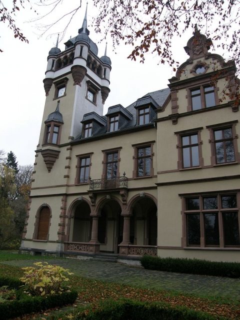
Gut Mielenforst is a manor house and former knight's seat in the Dellbrück district of Cologne. Today, after extensive renovation, it is used as a condominium complex ("Hofgut Mielenforst"). Gut Mielenforst is located on the edge of the Königsforst forest, by the Eggerbach stream and not far from the Mauspfad. The name is said to be derived from the Celtic "mil" = soft, swampy.
As early as 1196, a Konrad de Milinvorst was mentioned as "dapifer" (Latin: "provider of food" = seneschal) to the Count of Berg. A family of Milenvorst has been known since the 13th century. In the 15th century, the property reverted to the Counts or Dukes of Berg. In 1596, it was pledged to a knight named Heimbach called Hoen; at the end of the 17th century, it was owned by the von Steinen family, who held it until 1774 and had a new manor house built in 1711. Afterwards, it fell to the state and remained a domain.
In 1822, the Cologne notary Dr. Friedrich Hohenschutz acquired the estate with approximately 350 acres of land. In 1882, the textile industrialist Paul Andreae from Mülheim bought the estate from his daughter Josephine and her husband Franz Wilhelm Freiherr von Saint-Remy zur Biesen, which by then included approximately 750 acres of forest, pastures, and arable land. Andreae had the current manor house built by 1885 and gradually had the old farmstead demolished and replaced with historicizing new buildings. In 1904, the estate was converted into a family fideicommissum, and in 1909, the Andreae family was elevated to hereditary nobility by Emperor Wilhelm II.
After the end of the First World War, the New Zealand Rifle Brigade
of the British occupation force had its headquarters at Gut Mielenforst. A photo shows the later Edward VIII as Prince of Wales during a visit on January 18, 1919.
During the Second World War, Gut Mielenforst was an anti-aircraft control center for Cologne on the right bank of the Rhine. The tower, stripped of its helmet for flight safety reasons of the Cologne-Ostheim air base, was used as an observation tower. In the cellar of the administrator's house, soldiers painted office scenes, anti-aircraft guns, and a city panorama of Cologne framed by anti-aircraft searchlights on the walls. Beyond the pond, a deep bunker with two entrances was built in the park.
The Andreae heirs sold Gut Mielenforst to the city of Cologne in 1978. While the park was already placed under nature protection in 1959, Gut Mielenforst was included in the list of monuments of the city of Cologne (No. 669) in 1980. From 1988, the city tried to sell the estate, which was realized by transferring it to a development company on April 1, 1997. With the expiration of the lease period on October 31, 1999, the agricultural use of the estate also ended. The farmstead was converted into a commercial and 47 residential units by 2003 and transformed into partial ownership (planning: Badtke Architektur GmbH; landscape design: Brigitte Röde). The manor house remained undivided (except for the separation of the kitchen wing), and the historic roofscape, especially the helmet of the corner tower, was reconstructed. Buildings, courtyard area, and park are not publicly accessible. However, regular viewing appointments for the public were arranged with the Office of the City Conservator, for example on Open Monument Day.
Description+
Gut Mielenforst is a four-sided farmstead, consisting of a coach house wing in the west, stable and storage buildings in the north, a large cattle and sheep stable in the east, and tenant and servant houses and a fodder mill in the south. At the southwest corner is the manor house, which is connected to the tenant house by the main gate; another historic gate entrance is located at the northwest corner. Excavations around 2000 have shown that the farmstead previously only covered the western half of the current complex.
The Manor House+
The manor house is located at the preferred southwest corner of the farmstead. It was built between 1883 and 1885 according to designs by the Berlin architect Hans Grisebach. The two-story house in the German Renaissance style (Neo-Renaissance) is a plastered building with red sandstone details and has a tower at the southwest corner. The main facade faces south; on the ground floor, a loggia with three round arches opens, behind which lies the central hall of the house.
On the ground floor are the reception rooms: The dining room adjoins the transverse hall, to which the kitchen wing is connected. To the west is the ladies' or music room, designed in Louis-seize style. North of the hall, facing the inner courtyard, are the gentlemen's room with dark Baroque paneling and built-in bookshelves, as well as the staircase. The original furnishings were publicly auctioned after the death of the lady of the house in 1935.
The Park+
By relocating the Mielenforster Kirchweg, which originally ran directly past the manor house, to the southeast, space was gained for an extensive park. In place of earlier ditches and horse ponds, a pond divided into two halves by a bridge was created in front of the south and west facades of the manor house. A terrace was laid out in front of the main facade. Large trees structured the landscape park, of which only remnants are still visible today. On the Mielenforster Kirchweg there are two historic gate systems; the first leads next to the "mill" to the farm buildings. The second opens onto a chestnut avenue that leads through the park to the gatehouse between the manor and tenant house.
Take Mobile History with you
You are reading this text for free. Premium adds what matters on the road: descriptions read aloud, sites found through your camera, whole regions taken offline.
- Every description, including the ~17,700 Premium sites
- Audio guide: have descriptions read to you on location
- AR finder: see sites through your camera, with distance and bearing
- Unlimited saved sites
14 days free, then from €2.99 a month. Cancel anytime.
Source: Wikipedia · Licence: CC BY-SA 4.0
This description draws on the facts documented in the linked Wikipedia article; Wikipedia content is licensed under CC BY-SA 4.0. Wording and editing: Mobile History.
Location: 50.9614, 7.0676