To be privately owned
CastleMeschede
Laer Castle
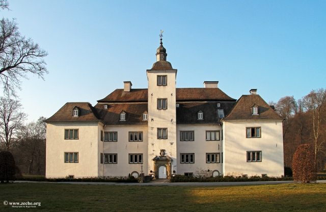
Laer Castle is located west of Meschede. The property was first mentioned in the 13th century. At this site, there was a medieval lowland castle, which was transformed into a palace in the 17th century after passing into the possession of the von Westphalen family.
The history of the settlement of Laer, consisting primarily of the Schulten-Hof and the Wulfes Hof, from which Haus Laer would later emerge, dates back to the 8th century. The first confirmed record of the Wulfeshof dates from 1268. In a document, the abbess of Meschede Abbey, Agnes von Arnsberg, attested to the acquisition of estates in Laer and Druvethe near Eversberg. By 1314, both farms belonged to Meschede Abbey. The Lords of Hückelheim were enfeoffed with the Wulfeshof by the abbey.
In the Middle Ages, a moated castle was built in a valley near the Ruhr river. Only minor remains of the original castle are preserved. A part was integrated into the later castle.
After the extinction of the lineage in 1449, it passed by inheritance into the possession of Hennekin von Berninghausen. As he also remained childless, he bequeathed the village of Hückelheim and the associated allodial property to the Galiläa Monastery in 1483. The Laer estate was not affected by this, as it was a feudal possession of Meschede Abbey. The property initially remained with other members of the von Berninghausen family. After the death of Johann von Berninghausen, inheritance disputes arose, which led to the property passing to Johannes von Overlaker in 1582.
In 1602, the property was bought by Heinrich von Westphalen, who was at that time the Paderborn Hofmeister. In 1610, he also bought the Schultenhof and two cottages. Since then, the estate has been in the family possession of the von Westphalens.
During the Electorate of Cologne period, ownership of the farm was associated with tax exemption and the right to attend the Landtag.
In 1776, the sovereign, Elector Maximilian Friedrich of Cologne, permitted the owner to build a stone bridge over the Ruhr near Laer and to levy a toll for its use after completion.
The most historically significant owner in the 19th century was Clemens August von Westphalen zu Fürstenberg, who, in connection with the Cologne incident, advocated for the release of the Archbishop of Cologne, Clemens August Droste zu Vischering, and temporarily left Westphalia after conflicts with the Prussian state.
From October 1944, the castle served as the headquarters of a military staff responsible for V2 rockets. Although construction of launch ramps near Meschede began, they were never used due to the advance of the Allies. At the end of the war, the complex was plundered.
Partially used as a recreation home until the 1960s, the castle is still inhabited by the family of the Counts von Westphalen today.
Construction History+
The castle, largely preserved to this day in the Renaissance and later Baroque style, was built starting in 1606/1608. Through further additions, it acquired its current form by the 18th century. A first completion was the erection of the Baroque portal and the Italianate dome of the tower in 1669. The originally three-story building featured a projecting stair tower and a side pavilion extension.
Further significant changes took place in the 18th century. The period around 1764 is given in the literature for this. However, since a painting from 1725 already shows the later state, the renewed reconstruction must have been essentially completed by this time. The pavilion-like extension in the east, present since the early 17th century, received a counterpart in the west. The entire building was reduced by one story and fitted with a mansard roof. In the 1760s, Friedrich Wilhelm von Westphalen, then Prince-Bishop of Hildesheim, oversaw the new construction of the outer bailey and the farm buildings. This complex is symmetrically arranged and consists of single-story parts and two-story pavilions with mansard roofs. The two-story gatehouse is aligned such that, together with an avenue and the tower of the manor house, a main optical axis is created.
The manor house was redesigned again in 1893, primarily internally. The spiral staircase previously located in the stair tower was replaced by a wooden staircase leading from the entrance hall to the upper floor. Iron beams were used to increase the height of the main hall. The hall then received a stucco ceiling modeled after Adolfsburg Castle. The stucco on the walls and a fireplace with the Westphalen-Ledebur coat of arms date from the 17th century. At the beginning of the 20th century, a riding hall was built, which features some Art Nouveau elements.
Chapel and Liborius Statue+
Still in the 17th century, the castle chapel, dedicated to Saint John the Baptist, formed the northeast corner of the outer bailey. It is a hall building measuring 14x10m. The origins of the chapel possibly date back to the Middle Ages. According to other sources, it was only built in the 17th century. At least the keystones and buttresses, the facade with a curved gable, and the facade can be dated to this period. The chapel was demonstrably consecrated on September 18, 1645. The coat of arms of the Westphalen-Löwenstein family was created in 1610. On the right side is the tombstone of Lucia Elisabeth von Ledebur, who died at Laer Estate in 1725. Prince-Bishop Friedrich Wilhelm von Westphalen had the interior of the chapel redesigned again in 1767. During this time, the roof turret was renewed. Inside, an 18th-century stucco ceiling can be seen. Noteworthy is the altar with a painting of the Baptism of Jesus by John the Baptist, as well as statues of Saint Liborius and Saint Godehard. The altar is considered a masterpiece by the Paderborn court painter Anton Joseph Stratmann. Holy Mass is still regularly celebrated in the chapel today. In 2003, some new stained-glass windows were installed. Originally located in the castle park, but separated from it by railway construction, a statue of Saint Liborius, made in 1763, stands nearby.
Iron Footbridge+
In 1839, a free-hanging iron bridge was built over the Ruhr. The first plans for a river-spanning structure came from Johann August Röbling, who later emigrated to the USA and planned numerous large iron bridges there. Around 1828, Röbling planned a bridge over the Ruhr near Freienohl. However, the project was not realized. But the architect A. Bruns drew on these plans when, commissioned by the Count von Westfalen, he built a pedestrian bridge near Laer Castle in 1839. This is considered one of the first of its kind in Germany. It was in use as a pedestrian bridge until the beginning of the 21st century. The bridge is the only one of its kind in Europe that has been preserved in its original substance. It is therefore a special technical cultural monument. It was also renovated until 2003 with funds from the German Foundation for Monument Protection. It was severely damaged by Hurricane Kyrill and has so far only been provisionally secured.
Watchtower+
In the course of the reconstruction measures of 1764, a lookout tower ("Wartturm") reminiscent of medieval models was erected at some distance from the castle. The building was connected to the castle complex by a park. The Laer tower ruin stands today in the middle of the forest. Earlier pointed-arch window openings have long been bricked up. The building is one of the few and particularly early examples of neo-Gothic influences from England present in Westphalia. The formerly crenellated tower originally gave the impression of being the last remnant of an old castle. This ruinous character was typical of English Gothicizing garden architecture. In contrast to, for example, Baroque park complexes, the tower was not in the axial extension of the road leading to the castle, but slightly offset from it.
Figures+
The property has an area of 1.7 hectares. The castle includes 12,000 m² of meadow and a park with old trees.
Take Mobile History with you
You are reading this text for free. Premium adds what matters on the road: descriptions read aloud, sites found through your camera, whole regions taken offline.
- Every description, including the ~17,700 Premium sites
- Audio guide: have descriptions read to you on location
- AR finder: see sites through your camera, with distance and bearing
- Unlimited saved sites
14 days free, then from €2.99 a month. Cancel anytime.
Source: Wikipedia · Licence: CC BY-SA 4.0 · Image: http://www.zeche.org/
This description draws on the facts documented in the linked Wikipedia article; Wikipedia content is licensed under CC BY-SA 4.0. Wording and editing: Mobile History.
Location: 51.3483, 8.2569