To be privately owned
CastleEisenach
Hohe Sonne Castle
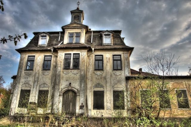
Hohe Sonne is a forest settlement of the Wartburg city of Eisenach in Thuringia. Hohe Sonne today consists of the ruinous building fabric of the Hohe Sonne hunting lodge, the adjacent Hohe Sonne rest stop with parking lot on Federal Highway 19, a residential building, and two transmission masts erected for postal and telecommunications purposes.
The building ensemble, known today as Hohe Sonne, is located on the Rennsteig, about six kilometers south of the Wartburg city of Eisenach on Federal Highway 19. The highest elevations of the place are the Gickelhahn (461 m above sea level), the nearby Hirschstein (463.3 m above sea level) and the Karthäuserberg (423.8 m above sea level) located southwest of the castle belong to the municipality of Marksuhl. The geographical elevation of the place is 434 m above sea level.
Not far from the castle, numerous hollow ways can be found in the terrain as witnesses of the old road once called Nürnberger Straße. The pass height of this much-used traffic route was called Hohes Kreuz. Whether a summit cross was present at this point remains speculative, as written mentions from pre-Reformation times are missing. The wooded surroundings within sight of the Wartburg were always a popular hunting ground for the Saxon high nobility. The stone cross Wilde Sau, erected around 1483, commemorates the tragic course of a wild boar hunt, in which a ducal court official died in a hunting accident. The hunting passion of Eisenach Duke Ernst August I initially led to the construction of a log cabin as a hunting lodge, which was replaced as early as 1741-46 by the hunting lodge built by the state architect Gottfried Heinrich Krohne. The forest area Hohe Sonne belonged to the municipality of Mosbach even before the First World War, which approved the construction of an inn in 1906. The surrounding forest, on the other hand, was largely grand ducal property, then state forest. Currently, the municipal boundaries of Eisenach (in the north), Mosbach (in the east), Eckardtshausen (south) and Wolfsburg-Unkeroda (west) meet exactly at the castle.
The building known today as "Schloss" (castle) with the small turret was last used as a hotel and excursion restaurant in the 1980s, but was closed as early as 1985 due to irreparable structural damage. The building and property are now privately owned and inaccessible. Appeals from citizen initiatives, associations and the city administration to save the listed building remained without consequence until 2012. The request of a Swiss interested party to demolish the former hunting lodge and instead erect a postmodern building of glass and steel was rejected. In 2012, there is a Dutch investor who wants to restore the dilapidated complex and turn it into a hiking hostel.
In addition to the castle building, a relatively small, three-story main house with a mansard roof, contemporary descriptions and illustrations also report on outbuildings, stables and accommodation for the servants. Most of these buildings were half-timbered buildings with external plank cladding – for weather and rain protection –.
Tourism+
Hohe Sonne is the starting point for hikes into the Drachenschlucht gorge. During GDR times, when entering the border area was not possible, all Rennsteig hikes started here, as did the GutsMuths-Rennsteiglauf until 2001. Furthermore, the Lulluspfad X 16, coming from the Edersee, ends here.
Take Mobile History with you
You are reading this text for free. Premium adds what matters on the road: descriptions read aloud, sites found through your camera, whole regions taken offline.
- Every description, including the ~17,700 Premium sites
- Audio guide: have descriptions read to you on location
- AR finder: see sites through your camera, with distance and bearing
- Unlimited saved sites
14 days free, then from €2.99 a month. Cancel anytime.
Source: Wikipedia · Licence: CC BY-SA 4.0
This description draws on the facts documented in the linked Wikipedia article; Wikipedia content is licensed under CC BY-SA 4.0. Wording and editing: Mobile History.
Location: 50.9319, 10.3179