Restaurant
CastleWeigenheim
Frankenberg Castle
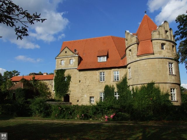
Frankenberg Castle is located in the southern Steigerwald, amidst vineyards on the so-called Herrschaftsberg in the municipality of Weigenheim.
On the plateau of the Herrschaftsberg in the Steigerwald, there were once two castle complexes: Hinterfrankenberg Castle and Vorderfrankenberg Castle. The widely visible Frankenberg Castle, which still stands today, is the successor to Vorderfrankenberg Castle and has a turbulent history.
The remains of Hinterfrankenberg Castle belong to the older of the two castles. The castle was owned by the Prince-Bishops of Würzburg. Due to territorial power struggles, the Burgraves of Nuremberg built a new castle in 1254 in the immediate vicinity, which was also called Frankenberg. Changes of ownership in both castles led to complicated power relations. Only after secularization were both castles united in ownership.
In the fight against the Catholic prince-bishoprics of Würzburg and Bamberg, Margrave Albrecht Alcibiades devastated Hinterfrankenberg Castle in 1554 during the Margrave War, along with Hohenlandsberg Castle on the neighboring Hohenlandsberg. Since then, Hinterfrankenberg Castle has been a ruin. A double tower of the fortification, moat systems, remnants of walls, and a well, which is however silted up and almost filled, still exist. On the grounds of Hinterfrankenberg Castle, there is a publicly accessible park and a private cemetery for the Barons von Pöllnitz and other individuals connected with Frankenberg Castle.
In the so-called Blaubeuren Treaty, Ulrich von Hutten was granted an amount of 27,000 guilders as atonement for manslaughter. A partial payment was made only in 1520, from which Hutten bought Frankenberg Castle on the western slope of the Steigerwald. This castle was occupied by Knight Ludwig the Younger Hutten (1493–1548), the founder of the Frankenberg line of the noble family. The von Huttens inhabited Frankenberg Castle until 1783, when the line died out. Their burial place is in the church of Reusch.
After the death of the last Hutten, the Ansbach Margrave Christian Friedrich Karl Alexander (1736 to 1806) granted the fief to Ludwig Karl Wilhelm von Pöllnitz (1724 to 1801) - the Pöllnitz family inhabited Frankenberg Castle until 1971. Between 1971 and 2008, the castle with approx. 100 hectares of land was owned by the Barons von Lerchenfeld. In 2008, the entrepreneur Roland Belz (deceased 2011) acquired the castle to convert it into an exclusive castle hotel.
Current Use+
The castle's outer bailey has been thoroughly renovated, and the premises can be rented as holiday apartments.
Currently, a reorientation of the estate is planned; gastronomy, castle, dairy, and existing land are managed by the owner Irmgard Belz (wife of the deceased owner Roland Belz).
A restaurant focusing on regional cuisine and a vinotheque have been established in the renovated old administrative building.
The Castle Cemetery+
A few meters northwest below the ruin of Hinterfrankenberg, on a terrace on the slope, is the private cemetery of Frankenberg Castle, where both servants and members of the castle lord's family von Pöllnitz were buried. The center of the cemetery is a now dilapidated neoclassical monopteros, and the graves of the deceased family members are arranged in a circle around the round temple.
The grave of the second castle owner from the von Pöllnitz family, Karl von Pöllnitz Frankenberg (1758-1826), is located not far from the castle and castle cemetery near the summit plateau of the Scheinberg, which at 499 meters is the highest elevation in the Steigerwald. The tombstone is on an island in the middle of a small forest lake.
Lands+
The lands of Frankenberg Castle are located on the western edge of the Steigerwald Nature Park and include vineyards, forests, and scattered orchards.
Take Mobile History with you
You are reading this text for free. Premium adds what matters on the road: descriptions read aloud, sites found through your camera, whole regions taken offline.
- Every description, including the ~17,700 Premium sites
- Audio guide: have descriptions read to you on location
- AR finder: see sites through your camera, with distance and bearing
- Unlimited saved sites
14 days free, then from €2.99 a month. Cancel anytime.
Source: Wikipedia · Licence: CC BY-SA 4.0 · Image: Mobile Geschichte
This description draws on the facts documented in the linked Wikipedia article; Wikipedia content is licensed under CC BY-SA 4.0. Wording and editing: Mobile History.
Location: 49.6083, 10.2655