Condominium apartment
CastleBad Langensalza
Dryburg Castle
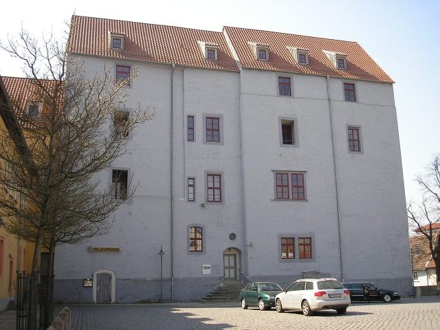
Dryburg Castle, a former castle complex with a dry moat and outer bailey, is today the oldest preserved residential building in Bad Langensalza in the Unstrut-Hainich district in Thuringia, a four-story building with an L-shaped floor plan.
The last buildings of the medieval Dryburg – the preserved west and south wings of the later castle – are located in the north of the historic old town of Bad Langensalza, between "Vor dem Schlosse" and "Am wilden Graben". After extensive renovation work in the 1990s, they now serve as residential and commercial buildings.
Lords of Salza
The builders of the castle complex, erected in the 12th century, called themselves Lords of Salza, after the settlement first mentioned around 900 and the small river of the same name. The Dryburg was the ancestral seat of this not insignificant ministerial family, close to the Thuringian Landgrave, to which Hermann von Salza, Grand Master of the Teutonic Order and confidant of Emperor Frederick II, probably also belonged.
In 1212, during the Staufer-Welf throne dispute, Emperor Otto IV besieged the castle with the famous siege engine, the trebuchet (triboch). Due to a chronicler's Latin text being misunderstood and mistranslated in the 15th century, Dryburg Castle (Sloss Driborg) got its name.
After 1212, Salza was apparently elevated to a city by Otto IV; in 1222, the settlement first appeared in a document as an oppidum (city). The city was fortified with walls and towers, and the Dryburg, incorporated into the fortifications, now lay behind the city wall.
Due to inheritance disputes, the Lords of Salza began selling their rights to the castle and the city from 1342. Three brothers sold their share to the Thuringian Landgrave, the Wettin Frederick II, the Serious, while the fourth brother sold his share to Archbishop Heinrich III of Mainz. In the spring of 1346, during the Thuringian Counts' Feud (1342–1346), the Landgrave's troops conquered the city, which had in the meantime been occupied by the Mainz forces. Salza and also the Dryburg were almost completely destroyed by fire. Johann, Heinrich, Günther, and Friedrich von Salza were enfeoffed by Landgrave Frederick, their liege lord, with new rights and estates in other places in 1347. In 1409, the male line of the Salza family died out.
Dual Rule
Landgrave Frederick and the Archbishopric of Mainz agreed in 1346 on joint administration and in 1350 on joint ownership of the city and castle. The Dryburg, burned down to two residential towers, was rebuilt by the bailiffs of the two lordships. In 1356, they also began building an extended city wall, which connected the two suburbs to the old town. The Dryburg now lay within the enlarged city and lost its importance as a defensive structure on the northern city limits; it was henceforth only a residence and official seat. With the withdrawal of the Archbishopric of Mainz, the joint rule ended in 1387; the city and castle were now in the sole possession of the Wettins.
Albertine Line
Through the Leipzig Partition of 1485, the northern part of Thuringia, including Salza and the Dryburg, came to the Albertine line of the House of Wettin. The castle transformed into a representative palace, which also served as quarters for many traveling regents and their retinues.
During the German Peasants' War in April 1525, several hundred peasants and citizens from Mühlhausen and Salza besieged the castle. They pressured the bailiff Sittich von Berlepsch and demolished the prison. Apparently, there was no further damage. In the Thirty Years' War (1618–1648), the castle was plundered several times, in 1632 by the cavalry of the imperial general Pappenheim. In December 1640, the Swedish Field Marshal Banér and his wife took quarters in the castle, which was occupied by the Swedes at that time.
The Langensalza district (Salza is first mentioned as Langensalza in a document in 1578), with the city and the castle, came to the Albertine secondary line of the Dukes of Saxe-Weissenfels in 1657. The castle was then expanded into a widow's residence. From 1717 to 1730, Friederike-Elisabeth of Saxe-Weissenfels lived at Dryburg Castle, and in 1745, Anna-Sophie-Elisabeth, the widow of the Duke of Saxe-Eisenach. After the extinction of the Saxe-Weissenfels secondary line, Langensalza with Dryburg Castle reverted to the main Albertine line in 1746. The widow of the last duke, Friederike of Saxe-Weissenfels, lived in the castle from 1746 to 1751. After her death, former servants and their descendants lived here until the beginning of the 19th century.
19th and 20th Century
After the period of French rule from 1806, the Langensalza district, with the Albertine part of Thuringia, came to the Kingdom of Prussia through the Congress of Vienna in 1815. Dryburg Castle now became the seat of various offices. The Rentamt (revenue office), the Salarienkasse (payroll office), and the Landratsamt (district administration office) were housed in the west wing, alongside the apartment for the Rentmeister (revenue master). The royal district court had its seat in the north wing since 1838. The castle chapel on the third floor and the large hall on the second floor were divided into individual offices by the erection of walls. The main tax office was located on the ground floor. In December 1899, the north wing burned down and was demolished the following year. In the south wing of the castle, the main customs office still existed in 1912, which was moved to Mühlhausen in 1925. In 1927, the city of Langensalza bought the remaining buildings of the castle and set up, among other things, four municipal apartments there. The local health insurance fund and the district employment office had their seats in the south wing. Parts of the west wing were used as a city library from 1949 to 1991, and parts of the south wing as a school.
Old Castle
Of the castle complex of the Lords of Salza, destroyed in 1346, only one residential tower has been preserved. Today part of the west wing, it originally stood at the southwest corner of the core castle, presumably free-standing in the courtyard area. A round-arched window opening, a latrine located in the wall, the remains of a twin window, the console stones of a fireplace, and other structural details still bear witness to the late Romanesque living space from around 1250. A second residential tower, preserved in 1346, stood in the northeastern area of the castle. Together with the north wing of the castle, it burned down in 1899 and was demolished. In the castle courtyard, a preserved strong foundation possibly indicates the location of the keep of the first castle complex, about whose exact design nothing further is known.
Reconstruction
During the reconstruction of the castle after 1346, an almost square complex was created, in which three castle houses stood, one of them in the northwest corner as part of the curtain wall. The preserved residential tower was incorporated into the house in the northeast corner and was extended upwards like a tower. The second residential tower, preserved to this day, was integrated into the house in the southwest corner. The buildings were not connected to each other. The two un-basemented castle houses on the west side had a cross-rib vaulted, windowless ground floor with access from the courtyard side in the east, which housed utility and storage rooms. The living rooms and bedrooms were on the second and third floors. The keep was obviously demolished, as it had lost its function due to the high castle houses. A multi-part gate system with a bridge over the dry moat, which could be flooded in an emergency, was located in the southeast corner of the complex. To the south, the core castle was bordered by a Zwinger wall. To the east lay the outer bailey – the later front castle – with the agricultural buildings and the official residence, separated from the core castle by a moat. One entered the inner castle courtyard, which was also built up in the area of the Zwinger wall – at the location of today's south wing – via a bridge and through a gate. Next to the gate stood the stable for mounted men with eight horse stalls and a stable bed. A small stable, which was used for "painful" (torturous) interrogation, adjoined it. There was also a cow shed and a small oven, a kiln with four racks, a bathhouse, a pump well, a kitchen, and a pantry. In the 15th century, a sheep house is also attested, but its location can no longer be determined.
Castle
In the 16th century, construction phases can again be identified. Around 1530, the two castle houses in the west were connected by the installation of a staircase. The northern house received a representative entrance with a chamfered door frame instead of the simple original door opening. In the 16th century, windows were also broken into the originally windowless ground floor of the west wing, and the roof trusses were rebuilt: the stepped gables were removed or reduced in their pitch, and all pinnacles were eliminated. In the north wing, two storage cellars were set up, and a chain prison for serious cases was installed in the cellar under the residential tower. In 1594, the gatehouse in the southeast received a half-timbered floor.
Only after the Thirty Years' War (1618–1648) were there again construction activities. In the desolate northeastern residential tower and in the adjoining house, five floors were added in 1665 for storing the grain tithe from the Langensalza district. Of the castle's rooms, the Blue Room with five windows, the Yellow Room with two windows, the Prince's or Dining Room with seven windows, the Living Room with four windows, the Hall with ten windows, and the lower vaulted Blue Room with four windows are mentioned in 1683. The location of the rooms is not always localizable due to the missing north wing today.
In 1694, work began on the construction of the ducal widow's residence. The central part of today's south wing was newly built for the castle kitchen. Unlike in the west wing, the rooms on the ground floor and upper floor here were heated. In the west wing, a door with an open staircase was installed in front of the staircase in 1705. The gatehouse, damaged after a fire, was restored in 1711. The castle tower was demolished in 1712, and the baroque building with a mansard roof, which survived until 1899, was erected on the existing wall structures of the north wing. In the west wing, extensive chimney systems were integrated into the gable walls to increase living comfort. The installation of the baroque staircase and the raising of the roof over the staircase also fall into this period. In 1718, the south wing was extended to the east and west to its current length. Construction work for the widow's residence continued until around 1720.
With the extinction of the Duchy of Saxe-Weissenfels in 1746 and the death of the last duke's widow in 1775, construction activities temporarily ceased. Only after the transfer of the Langensalza district to the Kingdom of Prussia in 1815 was construction resumed in the castle complex. Doors and partition walls were installed on the ground floor of the west wing, and apartments were created on the upper floor. Renovation work is also documented for the south wing. In 1900, the burned-down north wing was demolished, which led to work on the east side of the west wing: all openings in the northern area were bricked up and plastered. In 1936, the south wing was partially rebuilt on the ground floor. After the apartments were vacated, renovation of the historic buildings began in the 1990s.
The late Romanesque residential tower with its almost completely preserved living space from the mid-13th century, the two Gothic castle houses from the mid-14th century, an early baroque castle kitchen rarely preserved in its structures, and representative remains of the baroque widow's residence make the preserved substance of the Dryburg an architectural monument of supra-regional importance.
Take Mobile History with you
You are reading this text for free. Premium adds what matters on the road: descriptions read aloud, sites found through your camera, whole regions taken offline.
- Every description, including the ~17,700 Premium sites
- Audio guide: have descriptions read to you on location
- AR finder: see sites through your camera, with distance and bearing
- Unlimited saved sites
14 days free, then from €2.99 a month. Cancel anytime.
Source: Wikipedia · Licence: CC BY-SA 4.0
This description draws on the facts documented in the linked Wikipedia article; Wikipedia content is licensed under CC BY-SA 4.0. Wording and editing: Mobile History.
Location: 51.1091, 10.6463