The remains of the Castle can be visited
RuinBurgrain
Werdenfels Castle (Ruin)
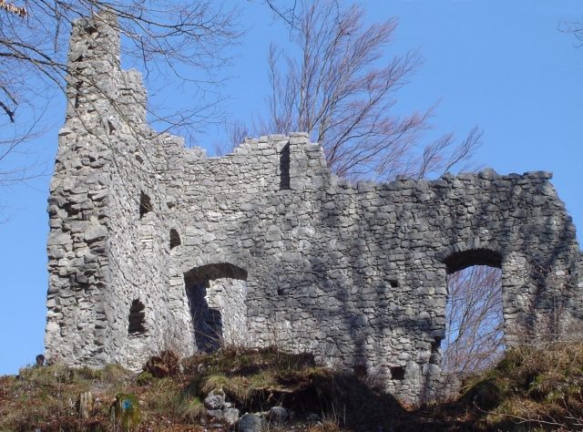
The ruin of Werdenfels Castle lies about 80 meters above the Loisach valley between Garmisch and Farchant in the district of Garmisch-Partenkirchen in Upper Bavaria. The spur castle served as the administrative center of the County of Werdenfels until 1632 and began to decay thereafter. The freely accessible castle ruin is a popular hiking destination and offers a good view of Garmisch-Partenkirchen and the Wetterstein Mountains.
The castle is located northwest of Garmisch-Partenkirchen on an eastern spur of the Kramerspitz in the Ammergau Alps. It lies about 80 meters above the valley floor and can be easily hiked on well-marked paths. From the northeast to the southeast, the terrain drops steeply into the valley with rocks, while southwest of the castle the terrain rises rapidly. This typical castle location allowed for remote monitoring of the important trade route in the valley, but direct intervention was not possible as the castle was too far away.
The founding date of the castle is controversially discussed in castle research. However, its construction is likely to have taken place between the years 1180 and 1230. The builder and the purpose of the original complex are also unknown.
From 1249, the fortress was owned by the Prince-Bishopric of Freising and was occupied by castle keepers or administrators. In 1294, Count Berthold III of Eschenlohe handed over part of his county to the Prince-Bishopric and was appointed castle keeper in return. After the founding of the Freising County of Werdenfels, the castle served as the seat of the administrative district and court. However, not all administrators took up residence in the castle. The county was generally considered "the best piece of the Imperial Principality of Freising" (Carolus Meichelbeck). It supplied "chamois, red and feathered game... wood, marble," which could be transported directly to the cathedral city via the Isar and Loisach rivers.
In the 15th century, the Freisingers had to pledge the complex several times due to lack of money. The structural condition of the castle seems to have deteriorated to such an extent by the beginning of the 17th century that the administrative seat was moved in 1632 to a new official building on the "Wang". From 1676, the fortress was exploited as a quarry. For example, numerous castle stones were reused in the reconstruction of the Baroque parish churches of Farchant and Garmisch.
In the course of secularization, the castle and county came to Bavaria. The approximately 5000 inhabitants of the formerly immediate imperial lordship initially found it difficult to get used to their new masters. A complaint from a Munich official from 1806 is preserved, stating that "many Werdenfelsers still do not have Bavarian hearts!" In 1822, the Bavarian State Councillor Ignaz von Rudhart acquired the ruin, which has been in private ownership ever since.
In 1905/06, the walls were secured and partially reconstructed. After securing the wall crowns in 1961/63, further renovation measures finally began in 1986, which have been continued in smaller sections ever since.
Description+
The local limestone, quarried in the "Schlosswald" above the fortress, served as building material for the castle. Also noteworthy there are the remains of six ring-shaped lime kilns, which were archaeologically investigated in 1997.
To the south and west, a shallow neck ditch protects the complex. The almost square, elevated core castle (27.6 x 24.8 meters) is fronted to the north and west by two outer baileys from the 14th and 15th centuries.
The keep stood at or above the northwest corner of the main castle, but is now completely gone, reduced to a rubble mound (demolition 1728/30). In the 15th/16th century, the tower also served as a prison. Better preserved are the north and an intermediate wall of the palas (24.8 x 11.4 meters, all dimensions according to Zeune) and the masonry of the two outer baileys with the - heavily renewed - "Mittertor" (middle gate).
The partially preserved north wall of the palas is interrupted on the ground floor by three large pointed arch openings, whose actual function remains a mystery to this day.
In its final stage of expansion, the castle was probably more an administrative seat than a defensive structure and would not have withstood a serious siege for long. The wall thicknesses average only about 90 centimeters, and the attack side was not reinforced or protected by flanking towers. The most defensible part was the High Medieval keep, which, however, is only known from some views from the 17th and 18th centuries.
The lack of defensibility of Werdenfels Castle was already noted by castle researcher Otto Piper. He recognized that the fortress, "as far as the masonry is still present, conspicuously lacks facilities and precautions for sustained defense." In his investigations, he finally came to the correct conclusion that the ruin "no longer corresponds to the older castle complex."
The associated farmstead was located to the south below in the valley at the site of the still preserved official building (Schwaige Wang).
Take Mobile History with you
You are reading this text for free. Premium adds what matters on the road: descriptions read aloud, sites found through your camera, whole regions taken offline.
- Every description, including the ~17,700 Premium sites
- Audio guide: have descriptions read to you on location
- AR finder: see sites through your camera, with distance and bearing
- Unlimited saved sites
14 days free, then from €2.99 a month. Cancel anytime.
Source: Wikipedia · Licence: CC BY-SA 4.0
This description draws on the facts documented in the linked Wikipedia article; Wikipedia content is licensed under CC BY-SA 4.0. Wording and editing: Mobile History.
Location: 47.5164, 11.0919