The remains of the Castle can be visited
RuinEltmann
Wallburg Castle (Ruin)
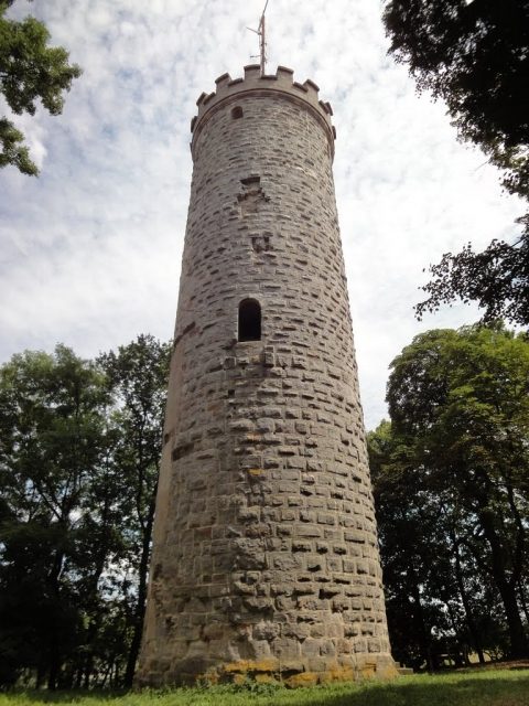
The Wallburg is a ruin of a spur castle on an offshoot of the Steigerwald south of Eltmann in the Haßberge district (Lower Franconia). Of the former official castle of the Prince-Bishopric of Würzburg, traces of the terrain and the keep have been preserved.
The name "Wallburg" - attested since 1303 - indicates an early historical or early medieval rampart. The high medieval castle uses almost the entire plateau (approx. 50 x 50 meters) of this ring wall, whose deep, later bricked-up moat offered welcome protection.
In 1316, the Prince-Bishopric of Würzburg had to pledge the Wallburg to Dietrich von Hohenberg. In 1363, it was pledged again to three lords from the Fuchs family. Dietrich Fuchs was able to acquire the entire complex in 1404. However, the Prince-Bishopric retained the right of repurchase, so that the castle reverted to Würzburg in 1477.
During the Peasants' War in 1525, the castle was damaged by the rebels, but subsequently restored. In 1542 and 1552, it was pledged again. From 1570, after the final redemption of the pledge, the fortress served as the administrative seat of the Eltmann office. Prince-Bishop Julius Echter initiated major renovations at the end of the 16th century, which are documented by the views of 1626 (Meissner) and Merian (1648). In the southwest rose the three-story main building with its gabled roof and curved ornamental gables. The keep was topped by a dome with a high lantern. In the north, lower outbuildings were located next to the gate. The defensive character of the complex was already significantly reduced.
In 1777, the Prince-Bishopric moved the administrative seat to the Saalhof in the city. The castle buildings subsequently served as a welcome quarry and today, apart from the keep and minor wall remains, have disappeared. At the end of the 19th century, the keep was converted into an observation tower.
Towards the end of the Second World War, the preserved keep was shelled by advancing American forces, as a German sniper position was suspected in the tower. The impacts of the two grenades are still visible.
Since April 2009, the area around the keep may no longer be used for events if the day in question is a public holiday.
Description+
The approximately square castle courtyard is protected by a surrounding moat. In the northeast, the high medieval, approximately 28-meter-high keep still stands upright. Above a beveled plinth, the cleanly jointed masonry of bossed ashlar with marginal drafting rises circularly. The complete absence of lifting holes is striking, so the stones were possibly still lifted with the older lifting tool, the wolf. The double wall shell is about 2 meters thick at the bottom, the diameter of the tower is about 8 meters. The obligatory high entrance is on the south side at a height of about 11 meters. In the 19th century, however, a second ground-level access was broken into the masonry to use the "Krautschtücht" as an observation tower. The projecting merlon top is an addition from around 1890. A view from 1626 (Meissner) shows the tower with a dome roof and a high pointed lantern. The keep was formerly divided into four floors by wooden ceilings. On the top floor, the wall thickness is only 1.2 meters. The tower room is lit by four round-arched windows with window seats. Even today, the tower can be climbed and offers a panoramic view of the Main valley, the Haßberge, and the Steigerwald.
The popular name "Krautstücht" is derived from the round shape of the tower, which resembles a wooden sauerkraut barrel. The keep also originally had no ground-level entrance. A "Stücht" for pickling cabbage also has no outlet opening at the bottom, similar to a bucket.
The old castle gate was probably in the north in front of the main tower. The slightly lower plateau in front of the access could originally have supported an outer bailey. The castle well with its romantic well house is in its current form a 20th-century addition. In the Middle Ages, this well is said to have been about 30 meters deep. The reconstructed well shaft only reaches down about four meters.
Only minor remains of the curtain wall are visible above ground. At the castle ascent, the so-called Schlosssteige, the old access was freely reconstructed by the local history association in 1985. The preserved sandstone figures from the 16th to 18th centuries and the coat of arms of the Fuchs family could be integrated here.
Take Mobile History with you
You are reading this text for free. Premium adds what matters on the road: descriptions read aloud, sites found through your camera, whole regions taken offline.
- Every description, including the ~17,700 Premium sites
- Audio guide: have descriptions read to you on location
- AR finder: see sites through your camera, with distance and bearing
- Unlimited saved sites
14 days free, then from €2.99 a month. Cancel anytime.
Source: Wikipedia · Licence: CC BY-SA 4.0
This description draws on the facts documented in the linked Wikipedia article; Wikipedia content is licensed under CC BY-SA 4.0. Wording and editing: Mobile History.
Location: 49.9677, 10.6698