Cultural Events
The remains of the Castle can be visited
RuinVlotho
Vlotho Castle (Ruin)
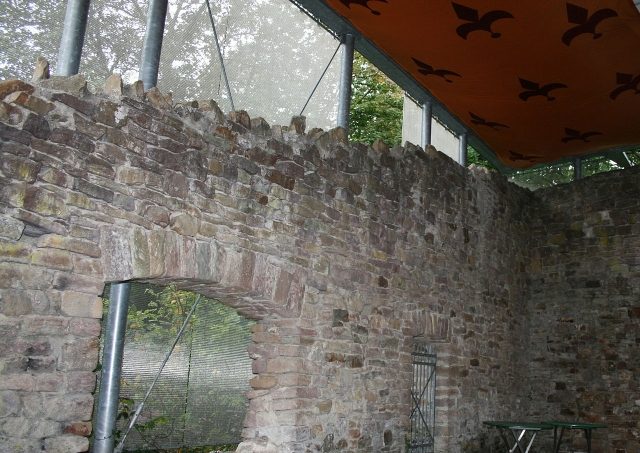
Vlotho Castle is a high medieval ruin of a hilltop castle above the town of Vlotho in the East Westphalian district of Herford (North Rhine-Westphalia).
The extensive complex is located on the 141-meter-high Amtshausberg almost 100 meters above the level of the Weser on a rocky outcrop. This is a spur of the so-called "Ebenöde". The slope drops steeply to the east and south. Minden is 14 kilometers north, Herford 14 kilometers southwest, and Bielefeld 26 kilometers southwest. There are traces of settlement from prehistoric times in the area.
A left-hand arm of the Weser created a natural harbor basin, and an important branch of the Frankfurt-Bremen trade route led to Vlotho on this section of the Weser, via Lemgo and Wehrendorf. Wehrendorf is now part of the Vlotho district of Valdorf.
The castle can be reached by car via the Bad Oeynhausen motorway junction and the connecting federal road 514, or by train via Vlotho regional station.
Settlement History
The castle hill was probably fortified by a ringfort about 2,000 years ago. At the time of the Carolingians around 850 AD, a fortified royal court was located here.
After the Lordship of Vlotho fell to Count Heinrich von Oldenburg (nicknamed "the Myldebogener"), a brother-in-law of Count Heinrich von Tecklenburg, in 1248, he built Vlotho Castle as his official residence around 1250. From here, trade on the Weser and the roads was monitored.
Although part of the County of Ravensberg, it temporarily came into the possession of Count Otto V of Everstein as collateral.
In 1368, the troops of the city of Minden destroyed Vlotho Castle and town. The reason was a feud with the County of Lippe. However, since the castle was needed as an administrative seat, it was rebuilt. At times, two dominions were administered from here.
In the turmoil of the Thirty Years' War and in the decades that followed, the castle changed hands several times, was plundered, and fell into disrepair.
In 1709, it was sold "for demolition" for 172 thalers. The principle: anyone who paid could break off a quantity of stones, depending on the amount of payment, as building material. In this way, the castle was largely dismantled.
In 1884, a restaurant was built on the castle grounds, and 14 years later, a "music shell" was added. It had the shape of a hollow quarter sphere, was erected in front of the restaurant and served as a canopy for concerts and other performances in the outdoor area. A semicircle was open to the audience, and there was a raised stage within the structure itself. There were two shells, but the second was demolished in 2001 due to protests from the residents of the Uffeln district on the opposite bank of the Weser regarding noise pollution from concerts. The sound actually carried far across the Weser, which lay a hundred meters below.
A so-called Bismarck Tower was built in 1903. It was located in the southeastern outdoor area, but only existed until 1936. In 1922, a new music pavilion was built by the Vlotho Volunteer Fire Department, which was demolished during the redesign of the castle grounds at the beginning of the 21st century and replaced by a tent stage.
From 1936 until the outbreak of World War II, extensive excavations of the ruins took place. Parts of the complex were secured, and some wall remains were restored, and the castle well was uncovered. The Bismarck Tower and the local history museum were demolished. In 1949, a new, solid pavilion was built, again by the Vlotho Volunteer Fire Department. It was demolished during the redesign of the castle grounds at the beginning of the 21st century and replaced by a tent stage.
Construction History
Reliable information about the construction history of Vlotho Castle is scarce; most of the information is based on speculation. After the castle was built around 1250, it was razed around 1368. Apart from the foundations, hardly any components from the High Middle Ages have been preserved. Although there are a few drawings from 1581, these do not show a definitive view of the castle. The existing models (including by W. Kreideweiß) are also based on conjecture. In 1709, the castle was systematically demolished and the site was practically leveled.
Current Use
Part of the reconstructed ruin has been covered with a modern protective roof, and weddings can be performed at a wedding stone. Music events and various markets take place on the castle grounds. Annually in May, the Recken zur Porta e.V. organize a historical castle festival. As part of the city tours, the "Burggemunkel" (castle murmur) is offered, where the grounds can be explored in the dark under guidance.
Complex+
The castle ruin is approximately 110 meters long and up to 60 meters wide. The curtain wall is largely still preserved. Of the former buildings, such as the palas, only foundation walls remain. The castle well currently has a depth of 52 meters. During the excavation of 1936/39, it had been uncovered to a depth of 63 meters, and it was already suspected at that time that it had a total depth of around 100 meters, which would have placed the bottom at approximately the same elevation as the Weser. In the extensive castle complex, there is a restaurant with a beer garden. From the terrace, there is a wide view over the Weser valley.
Take Mobile History with you
You are reading this text for free. Premium adds what matters on the road: descriptions read aloud, sites found through your camera, whole regions taken offline.
- Every description, including the ~17,700 Premium sites
- Audio guide: have descriptions read to you on location
- AR finder: see sites through your camera, with distance and bearing
- Unlimited saved sites
14 days free, then from €2.99 a month. Cancel anytime.
Source: Wikipedia · Licence: CC BY-SA 4.0
This description draws on the facts documented in the linked Wikipedia article; Wikipedia content is licensed under CC BY-SA 4.0. Wording and editing: Mobile History.
Location: 52.1714, 8.8594