The remains of the Castle can be visited
RuinStreitberg
Streitburg Castle (Ruin)
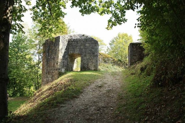
The castle ruin Streitburg or Burgruine Streitberg is the remnant of a high medieval noble castle above the village of Streitberg, a district of the market town Wiesenttal in the Upper Franconian district of Forchheim in Bavaria. It lies directly opposite the castle ruin Neideck, the landmark of Franconian Switzerland. The castle ruin is freely accessible.
The castle ruin is located on the high, rocky Streitberg, projecting to the southwest, above the village of Streitberg, which is bordered to the south and east by the Wiesent valley and to the west by Schauertal. The ruin can be reached via hiking trails from the village or the surrounding area.
Near the Streitburg ruin, many other former castles once stood: northeast the Burgstall Kulk on the mountain called Guckhüll, in a southeasterly direction the Neideck Castle and the motte Wöhr, located on a former river island of the Wiesent, near the hamlet of the same name. Approximately 250 meters southwest and above Neideck is the Burgstall Wartleiten, in the area of today's cemetery in Niederfellendorf a Burgstall of the Fellendorfer, and on the Hummerstein above Gasseldorf an early medieval Burgstall.
Surface finds from the 4th and 5th centuries indicate that the mountain already bore a Migration Period hilltop settlement. The exact time of the castle's construction is unknown. The Lords of Streitberg are considered as builders, who probably erected the castle, initially as a free property, before 1120.
At the latest since 1285, the Lords of Schlüsselberg, a powerful dynastic family, exercised feudal sovereignty over the castle or large parts of it. In 1303, a knight Bert de Streitberg was documented as a feudal tenant of the castle. After the extinction of the Schlüsselbergers in 1347, the castle came in equal parts to the Bishops of Bamberg and Würzburg, who allowed the Knights of Streitberg, who probably continued to own a part of the castle as a free property, to reside in the castle as vassals.
In 1508, the castle became the property of Margrave Friedrich of Brandenburg-Kulmbach. The complex was subsequently used as a military base and margravial administrative seat. Among the Hohenzollern Streitberger officials were Konrad Schott von Schottenstein, Beringer von Kotzau, and Ernst von Kotzau.
In 1523, the Swabian League marched with a force against the notorious robber knight Hans Thomas von Absberg. The mercenary band passed below Streitberg Castle, where official Conz Schott von Schottenstein, a brother-in-law of Hans Thomas von Absberg, resided, in the direction of Truppach Castle. There was a small exchange of fire, but the conflict did not escalate, and Streitberg Castle was not damaged.
During the Peasants' War in 1525, the castle also remained unharmed, but during the Second Margrave War in 1553, it was conquered and destroyed. Under the leadership of the Nuremberg Colonel Knight Haug von Parsberg and the Bamberg Colonel Claus von Egloffstein, whose Kunreuth Castle Margrave Albrecht Alcibiades had destroyed, the Bishops of Bamberg and Würzburg, together with the Nurembergers, stormed the castle on June 16, 1553.
Between 1562 and 1565, the castle was rebuilt. Plundered by imperial troops and damaged again in the Thirty Years' War in 1632, it served again as the seat of a margravial office from 1657 to 1791 after the damage was repaired.
Owned by the state of Bavaria since 1803, the complex was sold to the municipality of Streitberg in 1812, used as a quarry from 1811 to 1814, and almost completely demolished.
Construction Description+
The main castle was located on a high dolomite rock massif, falling almost vertically on three sides into the Wiesent valley. The north side, endangered by the rising terrain, was once fronted by a strongly fortified outer bailey, which is now completely built over.
Behind the wide neck ditch of the main castle, parts of the gatehouse from 1563/65 with a bastion and an advanced gun tower have been preserved. Behind the gate, remnants of the long stables and the forester's house can still be seen.
The castle path leads to a terraced landing with deep retaining walls, on which the large main building with its clock tower was erected in the 16th century. The Renaissance building has completely disappeared. The location of the former stair tower can still be recognized by the rock carvings. The stair tower provided access to the summit of a high rock dome. To the west, another building stood below this dome, whose outer wall has collapsed. Two barrel-vaulted cellars have been preserved, below which there is another cellar floor completely carved out of the rock with a dungeon. The cellar vaults are inaccessible to visitors.
Take Mobile History with you
You are reading this text for free. Premium adds what matters on the road: descriptions read aloud, sites found through your camera, whole regions taken offline.
- Every description, including the ~17,700 Premium sites
- Audio guide: have descriptions read to you on location
- AR finder: see sites through your camera, with distance and bearing
- Unlimited saved sites
14 days free, then from €2.99 a month. Cancel anytime.
Source: Wikipedia · Licence: CC BY-SA 4.0
This description draws on the facts documented in the linked Wikipedia article; Wikipedia content is licensed under CC BY-SA 4.0. Wording and editing: Mobile History.
Location: 49.8127, 11.2205