The remains of the Castle can be visited
CastleHofstetten-Flüh
Sternenberg Castle (Ruin) (Hofstetten-Flüh)
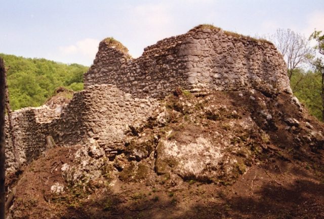
The Sternenberg Ruin is a former feudal castle located in the municipality of Hofstetten-Flüh in the canton of Solothurn, Switzerland. Perched on a natural rock outcrop, it now offers hikers an easily accessible glimpse into past eras.
History+
The origins of the site date back to around 1200, when a wooden castle was built on the rock. In the 13th century, a stone castle made of limestone was erected in the same location. The fortress, which included a solid residential building with a shield wall up to 3.55 meters thick, was inhabited by the Lords of Hofstetten from the mid-13th century until the first half of the 15th century. A redesign took place at the end of the 14th century. Around 1444, the castle was devastated by a fire, the cause of which is not clearly understood. In 1525, the hereditary fief was sold to the city of Basel, which in turn sold it to Solothurn by 1529 at the latest. Parts of the ruin were dismantled in 1852 for road construction. Between 1959 and 1960, excavations and conservation work were carried out. In 2008, the ruin was cleared of surrounding forest and its access paths were renewed.
Location+
The Sternenberg Ruin is located in Hofstetten-Flüh in the Dorneck district, canton of Solothurn, Switzerland, at an elevation of approximately 467 m above sea level.
On site+
The Sternenberg Ruin is now accessible to visitors and can be explored. The access paths and steps, renewed in 2008, facilitate the ascent.
Nearby+
- Château de Landskron (Castle), approx. 1.5 km away
- Rotberg Castle (Metzerlen-Mariastein) (Castle), approx. 2.2 km away
- Fürstenstein Ruin (Castle), approx. 2.3 km away
- Frohberg Ruin (Castle), approx. 4.5 km away
Take Mobile History with you
You are reading this text for free. Premium adds what matters on the road: descriptions read aloud, sites found through your camera, whole regions taken offline.
- Every description, including the ~17,700 Premium sites
- Audio guide: have descriptions read to you on location
- AR finder: see sites through your camera, with distance and bearing
- Unlimited saved sites
14 days free, then from €2.99 a month. Cancel anytime.
Source: Wikipedia · Licence: CC BY-SA 4.0
This description draws on the facts documented in the linked Wikipedia article; Wikipedia content is licensed under CC BY-SA 4.0. Wording and editing: Mobile History.
Location: 47.4785, 7.5050