The remains of the Castle can be visited
RuinStegeborg
Stegeborg Castle (Ruin)
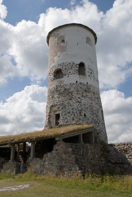
The Stegeborg Ruin, once a strategically important fortress, is picturesquely situated on an island in Slätbaken, a narrow Baltic Sea strait in the Swedish municipality of Söderköping. Its history stretches back far, bearing witness to a turbulent past as a royal residence and administrative center.
History+
The first documented mention of Stegeborg as "Stækaborg" dates to 1310. However, long before that, between 689 and 1012 AD, piles in the strait blocked shipping, as radiocarbon dating confirms. The oldest surviving parts of the current ruin originate from a square brick tower from the 13th century. In the 14th century, the complex was expanded into a simple residential castle with a curtain wall and a round tower. Under King John III, who was born here, Stegeborg experienced its largest construction phase, during which the visible round tower received its final form. The castle served as a favored residence for the kings of the Vasa dynasty and was supplemented by a castle church. Between 1652 and 1689, it was leased to Counts Johan Kasimir and Adolf Johan of Palatinate-Zweibrücken and functioned as an administrative seat for the Östergötland archipelago. After 1731, decay set in, and large parts of the castle were demolished to use the stones as building material in Norrköping. A new neoclassical castle was built in 1806 on a nearby estate.
Location+
The Stegeborg Ruin is located in Stegeborg, within the municipality of Söderköping in the Östergötland region, Sweden, at an elevation of approximately 15 m above sea level.
On site+
Today, the Stegeborg Ruin can be visited, offering visitors insight into its former significance.
Nearby+
- Mem Castle (castle), approx. 11.8 km away
- Johannisborg Ruin (ruin), approx. 29.3 km away
- Ringstaholm Ruin (ruin), approx. 32.7 km away
- Löfstad Castle (castle), approx. 34.7 km away
Take Mobile History with you
You are reading this text for free. Premium adds what matters on the road: descriptions read aloud, sites found through your camera, whole regions taken offline.
- Every description, including the ~17,700 Premium sites
- Audio guide: have descriptions read to you on location
- AR finder: see sites through your camera, with distance and bearing
- Unlimited saved sites
14 days free, then from €2.99 a month. Cancel anytime.
Source: Wikipedia · Licence: CC BY-SA 4.0
This description draws on the facts documented in the linked Wikipedia article; Wikipedia content is licensed under CC BY-SA 4.0. Wording and editing: Mobile History.
Location: 58.4414, 16.5989