The remains of the Castle can be visited
RuinEnkering
Rumburg Castle (Ruin)
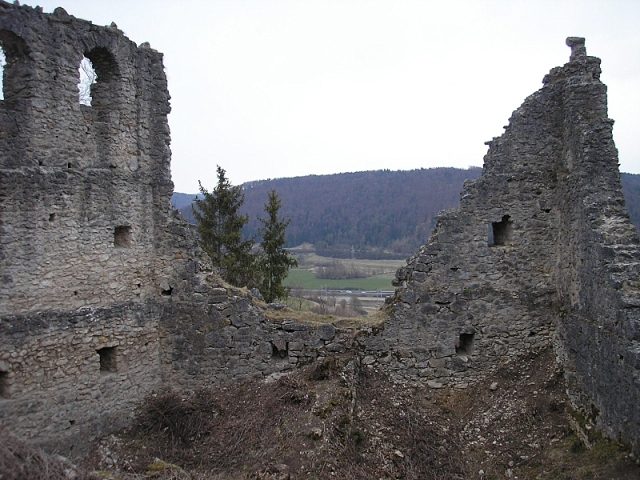
Rumburg Castle near Enkering, a district of Kinding in the Eichstätt district of Upper Bavaria, is a high to late medieval fortified complex, of which larger remains of the enclosing walls have been preserved. The ruin of the spur castle was partially renovated after 2000 and cleared of vegetation on the valley side.
The castle complex is located on the Schlossberg, a mountain spur projecting from the western valley edge of the Anlauter valley near Enkering, at approximately 450 to . The Anlauter flows northeast of the mountain into the Altmühl tributary Schwarzach. The Bundesautobahn 9 (Nuremberg-Munich) (Altmühltal junction) runs in its valley. The Schellenberg, rising to the east or beyond the Anlauter valley, bears an extensive prehistoric and early historical ring wall complex.
The Rumburg is the northeasternmost of the three medieval castle ruins in the Anlauter valley. A few kilometers to the west, the remains of Rundeck and Brunneck castles are preserved near Erlingshofen and Altdorf. On the valley edges above the Anlauter, several other castle sites and section fortifications of different periods are still recognizable in the terrain.
In the 12th and 13th centuries, several representatives of a noble family "von Enkering" are mentioned in documents: 1119 and 1162 Gozwin, 1253 Heinrich and Arnold. Where they resided is unknown, but certainly not at Rumburg.
Towards the end of the 13th century, the Lords of Absberg, after the Emmendorfers, came into possession of the lordship; around 1243 and again around 1294, a knight Heinrich von Absberg is mentioned, who, a vassal of the last Count Gebhard VII of Hirschberg, was already connected to Enkering. The preserved castle remains largely date back to the construction of the castle between 1350 and 1360 under the Absbergers, who had probably come into possession of the lordship of Enkering through an inheritance. The first documentary mention of this castle dates from 1361, when a Bavarian-wide noble tournament society was founded; its members included Goswin the Elder von Absberg, his son Goswin, and the knight Heinrich von Absberg "von Rannburch" (mentioned 1361-1400). The latter received in 1371 from the Bavarian dukes as collateral the right to grant protection to travelers "gen Nurmberg" (Nuremberg) through the Hirschberg county, and on October 13, 1374, from Emperor Charles IV, the privilege to make the "dorf Rumburg" a city, i.e., to fortify it, hold a weekly market, and erect a gallows. However, the Absbergers never fortified their place, and the city status was lost; the gallows were removed shortly before 1800.
From 1386, Bavaria held the right of opening at Rumburg, meaning the right of use in case of war. Heinrich (of Rumburg), born in 1409, was Heinrich III, Bishop of Regensburg from 1465-1492. In 1414, the Absbergers of Rumburg received the high justice of the area around Beilngries as an imperial fief; in 1496, Heinrich (Heinz) von Absberg of Rumburg sold it to the Bishop of Eichstätt. Under Lienhard/Leonhard Absberger of Rumburg (mentioned 1419-1448), the lordship's possessions were considerably expanded through the acquisition of the Emmendorfer prince-bishopric fief. Under him, the Rumburg line received in 1431 the right of asylum and the high and small hunting rights as a royal fief. The mentioned Heinrich (Heinz), mentioned 1487-1514, served as administrator in Dietfurt an der Altmühl in 1500/01 and as administrator at Mörnsheim Castle from 1506-1513. The Rumburg line also produced the knight Jörg (Georg), who became a canon in Regensburg in 1455 and served as chancellor to Margrave Albrecht Achilles of Brandenburg around 1460, as well as Hadmar, who is mentioned as provost in Berching in 1489, and then Karl, born in 1451, who succeeded his brother Jörg/Georg in the Regensburg canonry and was chancellor to Bishop Gabriel von Eyb of Eichstätt from 1510.
In the 16th century, the Absbergers of Rumburg became impoverished and acted as robber knights. In 1520, Erasmus von Absberg participated in an attack on Count Joachim von Oettingen, in which Oettingen lost his life. The sons of the murdered man appealed to the Swabian League for help, whose troops under Jörg Truchsess von Waldburg occupied Rumburg in 1521. From 1523, the lordship was placed under forced administration by an "ambtmann" by the Federal Assembly. In 1528, the outlawed Erasmus was able to obtain his rehabilitation at the Reichstag in Augsburg. His actions at the time were said to have occurred "out of his youth and lack of understanding," and he had also been seduced by his relative Hans Thomas von Absberg (of the Absberg line). In 1537, the impoverished brothers Erasmus and Heinrich could no longer maintain the right of escort to Nuremberg, so Bavaria redeemed the pledge. Around 1540, a devastating fire broke out in the castle due to a hunter; only the outer bailey was spared. In 1540, the lord of the castle Erasmus died without a male successor. The highly indebted heirs sold the lordship of Rumburg to the Prince-Bishopric of Eichstätt in 1546 after a settlement with the Absberg line, but still held the Emmendorfer fiefs in 1555, which only then reverted to the Prince-Bishopric. A reconstruction of Rumburg did not take place, and the complex began to decay. From 1552-1562, Absbergers, namely Hans Wolf and Hans Christoph the Younger von Absberg, unlawfully held Enkering in their possession once again.
In 1937/39 and again in 1964, the masonry of the Rumburg ruin was secured. After the collapse of smaller parts in 2003, the complex had to be temporarily closed and renovated. The scaffolding has disappeared again, but some parts are still at risk of collapse.
Description+
The core castle utilizes the natural projection of a mountain spur in the northwest of the village. On the mountain side, an unusually wide and deep neck ditch protects the castle. In addition, a spacious outer bailey was located here, whose rampart ditch has been preserved.
The floor plan of the main castle is approximately trapezoidal (approx. 23 x 45 m). Behind the neck ditch, the ring wall rises like a shield wall about 17 m high. The attack side is not reinforced, but small round arches on the inner side indicate tower-like structures. The residential building was located in the north above the valley. In the west wall, some associated window openings have been preserved, while larger sections of the wall are missing in the north and east, as is the wall to the castle courtyard. The unusually high ring walls were also the outer walls of the main building. Rumburg is therefore typologically classified as a mantle wall castle. The representative and defensive functions of a keep were taken over here by the "Hoher Mantel" (high mantle).
The castle gate was at the southeast corner, which is still preceded by the terrace of an outwork. In its current form, however, the gate is heavily restored. The adjoining window opening to the north collapsed in 2003. A second access is diagonally opposite on the west side. Outside, remnants of a painted marital coat of arms Absberg-Guttenberg are still recognizable on the plaster.
Legends+
According to a legend, the Absbergers of Rumburg, in alliance with the Bishop of Eichstätt, successfully fought the lords of Kipfenberg around 1301. Another legend tells of a black poodle guarding a chest with gold and precious stones at Rumburg; whoever goes to the castle silently on Walpurgis Night can chase away the dog and claim the treasure.
Take Mobile History with you
You are reading this text for free. Premium adds what matters on the road: descriptions read aloud, sites found through your camera, whole regions taken offline.
- Every description, including the ~17,700 Premium sites
- Audio guide: have descriptions read to you on location
- AR finder: see sites through your camera, with distance and bearing
- Unlimited saved sites
14 days free, then from €2.99 a month. Cancel anytime.
Source: Wikipedia · Licence: CC BY-SA 4.0
This description draws on the facts documented in the linked Wikipedia article; Wikipedia content is licensed under CC BY-SA 4.0. Wording and editing: Mobile History.
Location: 48.9948, 11.3572