The remains of the Castle can be visited
CastleKleinteil
Rosenberg Castle (Ruin) (Kleinteil)
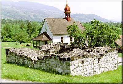
The Rosenberg Ruin, also known as the “Turm im Kleinteil” (Tower in Kleinteil), is a historic castle complex in the municipality of Giswil in the canton of Obwalden, Switzerland. It is one of several medieval fortifications that once lined the valley between Lake Sarnen and Lake Lungern.
History+
Rosenberg Castle, often referred to as the “Turm im Kleinteil,” was historically misattributed to a noble family named Rosenberg. However, recent research suggests it served as the residence for the Meier of Giswil. This family held the Meieramt (bailiff's office) and was responsible for high jurisdiction, which they inherited from the Vogts of Wolhusen. Mathis, documented in 1347, was one such Meier of Giswil. Later, the Meieramt passed to the Rudenz family, who in turn ceded it to Georg von Hunwil in 1361. After the Hunwil family moved away, the office was administered by officials until it was acquired by the parishioners in 1400. It is presumed that the Meier tower gradually fell into disrepair after this sale.
Location+
The Rosenberg Ruin is located in Kleinteil, a locality within the municipality of Giswil in the canton of Obwalden, Switzerland, at an elevation of approximately 554 meters above sea level.
On site+
Today, the ruin appears as a square of walls measuring approximately 8 by 9 meters. The masonry is characterized by a stable outer shell with a loose core and carefully worked cornerstones, with the walls being about 1.8 meters thick. The ruin is accessible to visitors.
Nearby+
- Rudenz Ruin (Castle), approx. 2.2 km away
- Hexenturm (Sarnen) (Castle), approx. 9.8 km away
- Landenberg Castle (Sarnen) (Castle), approx. 9.9 km away
- Restiturm Ruin (Meiringen) (Castle), approx. 12.1 km away
Take Mobile History with you
You are reading this text for free. Premium adds what matters on the road: descriptions read aloud, sites found through your camera, whole regions taken offline.
- Every description, including the ~17,700 Premium sites
- Audio guide: have descriptions read to you on location
- AR finder: see sites through your camera, with distance and bearing
- Unlimited saved sites
14 days free, then from €2.99 a month. Cancel anytime.
Source: Wikipedia · Licence: CC BY-SA 4.0
This description draws on the facts documented in the linked Wikipedia article; Wikipedia content is licensed under CC BY-SA 4.0. Wording and editing: Mobile History.
Location: 46.8321, 8.1555