The remains of the Castle can be visited
RuinRieshofen
Rieshofen Castle (Ruin)
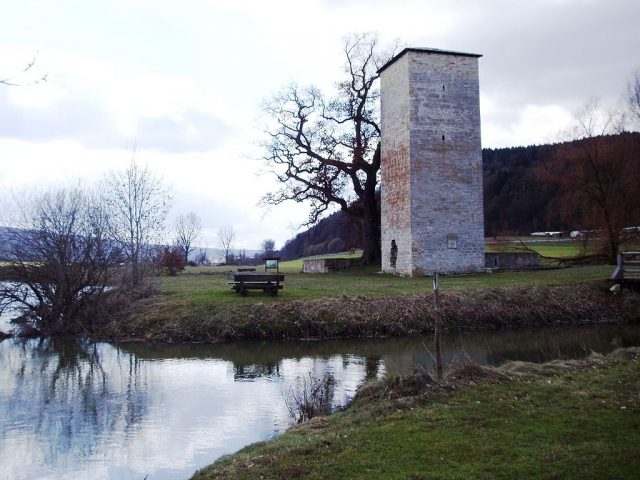
The ruin of Rieshofen Castle is located on the southern edge of the Walting district of Rieshofen in the Eichstätt district in Upper Bavaria. Remains of walls and the keep of the High Medieval moated castle have been preserved.
The Lords of Rieshofen are first mentioned in 1337 with "Pertholt de Rodeshouven". The small moated castle probably originated around 1290 as the seat of this ministerialis family of the Prince-Bishopric of Eichstätt and was a bishop's fief. East of the fortress, the remains of an older predecessor complex were excavated; possibly the original seat was in the area of the church.
As early as 1310, the widow Elsbeth von Rieshofen had to sell her fief to the Eichstätt cathedral chapter for economic reasons, although her two sons were still alive. However, the family continued to live in Rieshofen and is still traceable here in 1346. The cathedral chapter appointed a caretaker to the castle; in 1346, the knight Ulrich von Morsbach and in 1406/07 Burkhard Reichtershofer are named as such.
The manor belonging to the castle was operated by the cathedral chapter under its own management, i.e., assigned to a Kalteis family, who can still be traced here in the 16th century (1544 Ursula Kalteis in Rieshofen). It was probably merged with the second manor in the village around 1480.
The castle itself seems to have become dispensable. The bridge was last repaired around 1484. As early as 1561, there is talk of a "Burgstall", i.e., a ruin. In 1602, the ministerialis seat had disappeared except for wall remains and the keep.
The name "Hungerturm" (Hunger Tower) for the Rieshofen tower goes back to an event in 1689. The Jewish man Joseph from Tögung was accused of fencing stolen silver liturgical vessels and was sentenced to death by the Eichstätt criminal court. To execute the sentence, the alleged fence was thrown into the tower and left there to starve to death in agony.
The "memorial plaque" installed in 1861 erroneously identifies the tower as a Roman structure.
In 1985/86, safety measures and excavations were carried out in the castle area, and part of the moat was restored.
Description+
The rectangular core castle is surrounded by the remains of a moat fed by the Altmühl river. The actual castle area measures about 26 × 32 meters, the core castle only about 12 × 14 meters.
In the southeast, the approximately 18-meter-high keep, which has been topped by a low pyramid roof since 1985, rises up. Its floor plan is square, with sides about seven meters long. In the basement, which served as a dungeon, it has walls 1.60 meters thick. In total, above a plinth of limestone ashlar, there are three floors of rubble masonry, which were separated inside by wooden intermediate floors. Some narrow light slits let sparse daylight into the interior. The obligatory high entrance to the residential floor is on the west side (closure broken out); for a long time, a breach in the wall at the base of the tower has also provided access. From the residential floor, one reached the defensive floor via a small staircase; this uppermost floor is spanned by a barrel vault, which means that the tower was probably not much higher originally.
The small palas stood freely west of the keep in the middle of a simple curtain wall, which was not fortified by any tower structures. The foundations of the curtain wall and the palas were uncovered, preserved, and partially rebuilt in 1985/86. At the same time, the moat was re-deepened, and a wooden bridge, which had been newly built in the meantime, was erected at the original location.
The entire complex vividly conveys the image of a small, High Medieval ministerialis castle in the vicinity of a larger center of power.
The ruin is freely accessible at all times and serves as a resting place for Altmühl canoeists.
Take Mobile History with you
You are reading this text for free. Premium adds what matters on the road: descriptions read aloud, sites found through your camera, whole regions taken offline.
- Every description, including the ~17,700 Premium sites
- Audio guide: have descriptions read to you on location
- AR finder: see sites through your camera, with distance and bearing
- Unlimited saved sites
14 days free, then from €2.99 a month. Cancel anytime.
Source: Wikipedia · Licence: CC BY-SA 4.0
This description draws on the facts documented in the linked Wikipedia article; Wikipedia content is licensed under CC BY-SA 4.0. Wording and editing: Mobile History.
Location: 48.9325, 11.3066