The Ruin can't be visited
RuinHöllrich
Reußen Castle (Ruin)
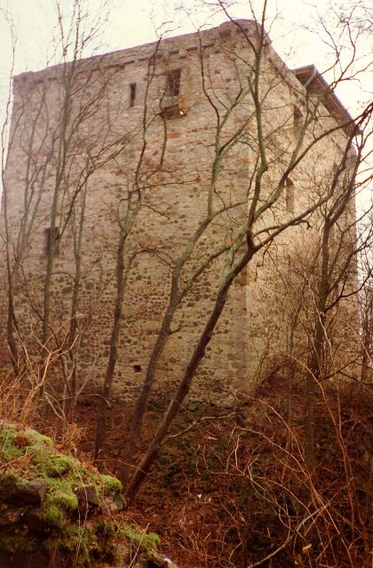
The Reussenburg, also known as Reussenberg, was a hilltop castle near Höllrich southwest of Hammelburg in the Lower Franconian district of Bad Kissingen in Bavaria. The Barons of Thüngen were first mentioned in documents around 1320 as landowners in Bonnland and erected the Reussenburg on a neighboring hill in 1331. In 1356, Reuss I. von Thüngen was considered the owner of the place.
The Fateful Year 1523
The end of the 15th century marked a time of upheaval. The loss of power of Emperor Charles IV and the election of Charles V greatly exacerbated the insecurity on the roads in the German Empire. Robber knights roamed the area, traveling merchants or envoys feared nocturnal attacks and could no longer feel safe. Although an eternal public peace had been decided at the Diet of Worms in 1495, this measure did not contribute to settling the unrest. Seven years earlier, in 1488, Franconian and Swabian imperial estates, led by Nuremberg, formed the so-called Swabian League. The aim of this alliance was to reduce attacks on traders and other travelers through cooperation. In 1489, the League was finally appointed as the imperial executive, i.e., the executive power.
In the middle of the 16th century, the robber knight Hans Thomas von Absberg abducted merchants from imperial cities in Franconia and Swabia during their trade journeys and demanded a high ransom for their release. To reduce the growing danger of being caught by troops of the Swabian League, he sought allies who would support him in his raids and hide his prisoners in their castles when danger arose. Hans Jörg von Thüngen also supported him in his feud, hoping to replenish his dwindling riches a little. In 1523, the League finally sent its troops to raze a total of 23 "robber's nests" to the ground. The League's troops, consisting of 10,000 foot soldiers and 1,000 horsemen, carried 100 cannons and 30 arquebuses as armament, for which they had 900 hundredweight of gunpowder. On June 26, the troops reached Reussenberg Castle and blew it up to prevent the return of the Thüngen family. In 1525, rebellious peasants destroyed the remains of the castle, which was never rebuilt thereafter.
The Woodcut by Hans Wandereisen
The castle is depicted on Hans Wandereisen's woodcut on a rocky spur. Through the outer castle gate, one enters the interior of the relatively small complex. In the forecourt, two smaller buildings can be identified, partly built into the wall. The palas and keep can no longer be precisely distinguished, as only the foundations of the main part of the complex are visible. The League's troops are mainly visible in the village below the castle. They consist of about 50 horsemen and 5 higher officers on the left and 9 landsknechts in the center of the image. On the right edge of the image, three more horsemen can be seen.
Location and Condition of the Castle Today
Today, the castle ruin is located on the Hammelburg military training area (restricted area) approximately three kilometers east of the village of Höllrich, on a densely wooded mountain. The building is not visible from the outside except for the last 10 meters and can only be reached by a steep ascent through dense forest. From the newly constructed wooden observation deck, about four stories high, within the ruin, one has a beautiful view over the restricted area and the surrounding landscape.
The ruin is in good condition for its age; there is no danger of collapse. Still present are the surrounding rampart, presumably designed as a dry moat, the main entrance which can be reached by newly constructed steps, and three-quarters of the former outer wall. All gates and doors are designed as round arches (a total of three, including the main gate) and have heights of approximately 2.50m for the main gate down to approximately 1.60m for the inner courtyard. There are no traces of fire on the remains.
Since the ruin is located in a restricted area, it can only be visited in exceptional cases. Visiting dates, as in the past during an open monument day, are announced in the press. The Wildflecken Military Training Area Command, Hammelburg branch, is responsible.
Take Mobile History with you
You are reading this text for free. Premium adds what matters on the road: descriptions read aloud, sites found through your camera, whole regions taken offline.
- Every description, including the ~17,700 Premium sites
- Audio guide: have descriptions read to you on location
- AR finder: see sites through your camera, with distance and bearing
- Unlimited saved sites
14 days free, then from €2.99 a month. Cancel anytime.
Source: Wikipedia · Licence: CC BY-SA 4.0
This description draws on the facts documented in the linked Wikipedia article; Wikipedia content is licensed under CC BY-SA 4.0. Wording and editing: Mobile History.
Location: 50.0678, 9.8208