The remains of the Castle can be visited
RuinRauhenzell
Rauhlaubenberg Castle (Ruin)
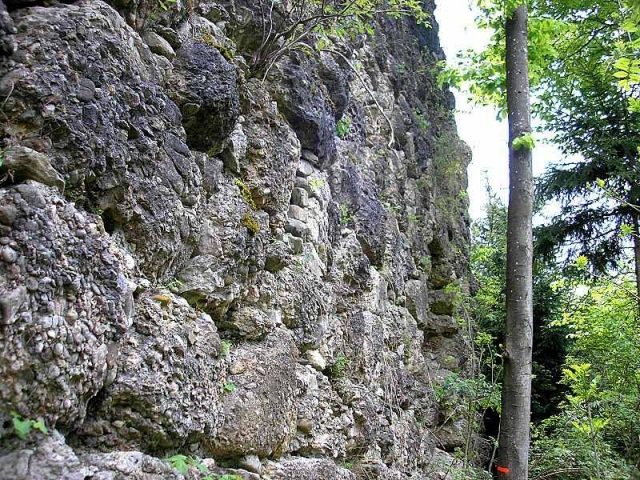
Rauhlaubenberg Castle is located about one kilometer northeast of the Immenstadt district of Rauhenzell (Oberallgäu district, Swabia) on a wooded hill spur. In addition to the ruins of the mighty high medieval residential tower, traces of the terrain and a remnant of the curtain wall have been preserved.
The hilltop castle was probably built at the beginning of the 13th century by the Counts of Montfort. Around 1265, the counts gave the lordship as a fief to the Lords of Laubenberg. This family of ministeriales also inhabited the neighboring Laubenbergerstein Castle as a fief of the Diocese of Augsburg.
In 1390, after the death of Rudolf IV of Montfort-Feldkirch, the lordship fell to Austria. In 1414, the castle was captured and occupied during a feud between Völk von Laubenberg and his brother-in-law Ulrich von Heimenhofen zu Fluhenstein. However, the castellan was able to take refuge in the nearby Laubenbergerstein Castle. The following year, Heimenhofen returned the fortress to Völk von Laubenberg after Count Wilhelm von Montfort-Tettnang mediated between the two parties. Ulrich von Heimenhofen, however, reserved the right to open the castle to use Rauhlaubenberg as a base during his feud with the Prince-Bishopric of Augsburg.
When Völk von Laubenberg died unmarried in 1423, his brother Hans inherited the fief. The lord of Laubenbergerstein Castle later passed the lordship on to his sons Jos and Kaspar.
In 1464, the Laubenbergers divided their family property. Kaspar received Laubenbergerstein Castle. Hans, the son of Jos von Laubenberg, was awarded Rauhlaubenberg Castle and the family's original ancestral seat - Alt-Laubenberg Castle near Grünenbach in Westallgäu.
During the German Peasants' War, the rebels plundered the castle in 1525. In 1579, the hardly inhabited complex burned down. The Laubenbergers had already moved to their new castle in Rauhenzell twenty years earlier. The useless hilltop castle was abandoned after the fire.
In 1657, the lordship came as an Austrian fief to the Tyrolean Chancellor Johann Andreas Pappus von Tratzberg. After the death of the last Baron Pappus von Tratzberg, the ruin passed to the Barons von Lerchenfeld in 1934. In 1935, at the initiative of Kempten's mayor and passionate castle researcher Otto Merkt, a memorial plaque was placed on the residential tower.
Today, the small castle site lies almost unnoticed in the forest above the hamlet of Egg. No modern safety measures are visible. Some brick infills between the Nagelfluh blocks of the tower date from an older period.
Description+
The fortress is located about 25 meters above the associated - still inhabited - former farm or economic courtyard (Egg) on a hill that has partially slipped into the valley. A small plateau, which can probably be interpreted as an outer bailey, is located north of the ridge, which today only remains as a narrow crest. To the northeast and northwest, a wide, shallow ditch runs around the foot of the hill.
To the west, some path traces lead from the hiking trail after a short ascent to a transverse ditch about two meters deep southwest of the main castle cone. The castle site, which is apparently rarely visited, is not marked by any sign.
The main castle consisted only of a large residential tower made of huge Nagelfluh blocks, which were partly worked into bossed ashlar with marginal drafting at the edges. A few stones of the outer shell consist of other stone material. The eastern part of the imposing keep has long since collapsed along with the castle hill. A high curtain wall ran around the tower, of which a few meters still stand upright in the southwest.
The west side of the residential tower is still preserved to a height of about eight meters. To the south, the masonry ends after about four meters at the break-off edge. Here in the east, a narrow path (danger of falling) allows ascent to the top of the wall of the west wall. A small, semicircular recess in the northern part of the inner wall is noteworthy.
In the south of the west wall, a large breakout point at the base of the tower endangers the masonry substance. However, the gap in the wall could be bricked up with relatively little effort. In spring 2008, three large Nagelfluh boulders of the infill that had recently broken out demonstrated the urgency of this measure.
The ruin is not safe to visit. Especially when wet, climbing into the interior of the tower is very dangerous.
Take Mobile History with you
You are reading this text for free. Premium adds what matters on the road: descriptions read aloud, sites found through your camera, whole regions taken offline.
- Every description, including the ~17,700 Premium sites
- Audio guide: have descriptions read to you on location
- AR finder: see sites through your camera, with distance and bearing
- Unlimited saved sites
14 days free, then from €2.99 a month. Cancel anytime.
Source: Wikipedia · Licence: CC BY-SA 4.0
This description draws on the facts documented in the linked Wikipedia article; Wikipedia content is licensed under CC BY-SA 4.0. Wording and editing: Mobile History.
Location: 47.5644, 10.2491