The remains of the Castle can be visited
RuinBeuron
Pfannenstiel Castle (Ruin)
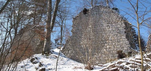
Pfannenstiel Castle is the High Medieval ruin of a spur castle of unknown social affiliation in the municipality of Beuron in the Sigmaringen district of Baden-Württemberg. Today, only sparse and mostly overgrown remains of the former spur castle can be found here.
The freely accessible castle complex "auf dem Stiel" is located on the eastern edge of the valley, at the highest point of a long, narrow, east-west oriented spur ridge above the Bära, which flows into the Danube as a left tributary near the town of Fridingen in the Tuttlingen district. The castle is located on , the Bära valley near . The former border between Württemberg and Baden runs directly through the southwest part of the castle grounds.
Little is known about the history of the castle. According to oral tradition, Pfannenstiel Castle was destroyed by fire following a nocturnal lightning strike. A knight's daughter is said to have died in the fire, having ordered a servant to drown her younger brother beforehand. However, the servant handed the child over to an old woman in the Bära valley. The "brother, who had grown into a stately youth," wanted nothing more to do with Pfannenstiel and is said to have then built Kreidenstein Castle on the neighboring rock.
Shard finds and masonry techniques suggest the castle was built in the second half of the 13th century. By 1400, it was already uninhabited and owned by the Lords of Urbach. Through Margarethe von Urbach, who brought the castle as a dowry, it came to Georg I von Werenwag. In 1476, he sold the Pfannenstiel castle site with the Eck district and all accessories to Beuron Abbey and Hans Spretter von Mühlheim. With the secularization in 1803, the Beuron property with the Pfannenstiel ruin passed to the Princes of Hohenzollern-Sigmaringen, who still own it today.
Description+
Access to the outer fortification of the entire complex was from the "Hart" plateau in the east, a narrow strip of land between the Danube and Bära valleys. A neck ditch separated the outer fortification and the walled castle courtyard located to the northwest. The location of another building can be identified in the castle courtyard.
The bailey was located to the west of the complex and protected the castle from the narrow side from the direction of the Bära valley. To the north, the slope drops into a dry valley. The bailey, at about 795.6 meters above sea level, was secured from the west by a rampart and a section ditch. The remains of the core masonry of the bailey can still be seen on a triangular area measuring approximately 19 by 18 meters.
The main castle is separated from the bailey to the west by another, lower section ditch. It is dominated by the approximately 5.5-meter-high stump of a keep, a 12 or 11.5-meter-wide and almost 23-meter-long residential tower-like structure at about 804.3 meters above sea level. The wall thickness is 2.7 meters on the northwest wall, 2.5 on the southeast wall, and about 2 meters inside. It has an interior space of about 145 square meters. The opening in the northwest wall near the ditch can be considered an access to an oriel, also a latrine. To its left is the remains of an intermediate wall that is not bonded to the outer wall. In the southeast wall there is a 2.5-meter-thick and still about 7-meter-high breach. Here, around 1900, the gate jambs and the bolt hole could still be identified. According to Günter Schmitt, this was the access from the upstream, trapezoidal castle courtyard, which required a retractable wooden staircase or a fixed ramp to overcome the height difference.
Take Mobile History with you
You are reading this text for free. Premium adds what matters on the road: descriptions read aloud, sites found through your camera, whole regions taken offline.
- Every description, including the ~17,700 Premium sites
- Audio guide: have descriptions read to you on location
- AR finder: see sites through your camera, with distance and bearing
- Unlimited saved sites
14 days free, then from €2.99 a month. Cancel anytime.
Source: Wikipedia · Licence: CC BY-SA 4.0
This description draws on the facts documented in the linked Wikipedia article; Wikipedia content is licensed under CC BY-SA 4.0. Wording and editing: Mobile History.
Location: 48.0467, 8.9400