The remains of the Castle can be visited
CastleMesocco
Mesocco Castle (Ruin)
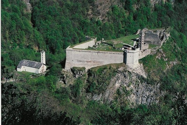
The ruins of Castello di Mesocco are located on a mighty rock south of the village of Mesocco in Misox in the canton of Graubünden, Switzerland. Mesocco is one of the largest castle complexes in Switzerland and formed the aristocratic center of the valley from the beginning of the 13th century until 1526. At the foot of the castle hill stands the Romanesque church of Santa Maria del Castello, also first mentioned in 1219.
The complex consists of four main parts: the outer bailey in the northeast, the main castle on the rock plateau, the inner bailey "Rocca" within the main castle, and the church of S. Carpoforo.
Outer Bailey
Remains of an irregularly running, 1.5-meter-thick curtain wall have been preserved from the outer bailey. There are no indications of buildings or an outer gate. The church of Sta. Maria del Castello is included in the outer bailey. The ascent to the main castle was made through the forecourt over the eastern flank of the hill, which was reached via a drawbridge.
Main Castle
The main castle extends over the entire area of the rock head. A strong curtain wall runs all around along the edge of the terrain. It was built in the 13th century, enclosed the entire area, and was fortified with battlements and five towers. The strongest tower, the Torre grossa, stood on the east side and had a wall thickness of 5 meters. The tower at the northwest corner with its polygonal ground plan has been partially rebuilt. Remains of a common room are found on its upper floor. All towers have loopholes.
In the Middle Ages, various buildings stood on the now wide inner area, which significantly reduced this space. Along the east wall were the stables, a cheese dairy, a foundry, a bakery, and the cistern.
Inner Bailey "Rocca"
The inner bailey leans against the west wall and essentially consists of the main tower, a paved courtyard with a cistern, the west wing, and the north wing. When the inner bailey was built is not clear; a time in the 11th or 12th century is assumed. Extensive alterations from the 15th century and the improper procedure by Eugen Probst during the excavation and securing works of 1925/26 have largely obscured the architectural-historical contexts of the older building periods; essential questions of settlement history can no longer be answered.
The once five-story tower in the east corner of the Rocca was built between 1150 and 1200. It has been preserved to a height of 8 meters and formed the most powerful structure of the medieval castle complex. The high entrance was on the west side and was accessible via a subsequently added stone staircase; the original access was via a wooden structure.
Considerable wall remains have been preserved from the mighty building from around 1400 on the north side of the inner bailey, the three-story Palazzo with a projecting stone gallery, similar to Norantola Castle. Window openings with seat niches and a fireplace are visible in the walls. On the outside of the curtain wall was a latrine shaft with two seat niches on different floors. The remains of the paintings date from the early 15th century.
Church
Inside the church of San Carpoforo with its horseshoe-shaped apse, there are foundation remains of a predecessor building with a round apse from the 6th or 7th century. This early medieval church was replaced in the 11th century by a new Romanesque building with a freestanding campanile. The transverse wall was added later. The painting is said to have been largely intact in the 17th century. Next to the church stands the seven-story campanile with its coupled round-arch windows. A burial site has not been proven.
Archaeological finds confirm the settlement of the complex since the Neolithic Age. The oldest complex was probably an early medieval church castle from the 6th or 7th century. Apart from foundation remains in the church, no traces of residential buildings from that period have been preserved.
The Castello is first mentioned in 1219 in a deed of foundation. Presumably, the Barons of Sax built a medieval castle in the former church castle, which was to remain their residence for about four centuries and from which they established their rule over Misox.
In connection with the Milanese campaigns, the Confederates, the Duchy of Milan, and the Grey League sought control over Castello and the Lordship of Misox. In 1479, the Castello was occupied by the Grey League, and in 140, Mesocco and Soazza were admitted to the League. Milan withdrew as an interested party out of consideration for the Confederates and put forward the Milanese condottiere Gian Giacomo Trivulzio, who on November 20, 1480, bought the castle and the rights of lordship in Misox and Calancatal from Count Johann Peter von Sax for 16,000 Rhenish guilders.
Trivulzio expanded the castle into a late medieval fortress, reinforced walls and towers, and equipped it with rifles and cannons. It was now considered "only conquerable by betrayal or hunger." In 1496, Trivulzio joined the Grey League and committed to supplying weapons and provisions from the castle if needed, which happened during the Swabian War, the Battle of Calven, and the 1st Musso War.
Fearing the takeover of the fortress by foreign powers, the Three Leagues had the castle razed, or rendered unusable, in 1526 against fierce resistance from Trivulzio; the masonry largely remained intact. A large part of the weapons and cannons was brought to Mesocco, where they were bought by the Bündner in 1541.
Subsequently, the complex began to decay. In 1835, the main tower was destroyed by a lightning strike. In 1925-26, the castle was excavated and stabilized by "Pro Campagna" under the direction of architect Eugen Probst. During restoration work between 1986 and 1993, the polygonal west tower and the walls in the north and northwest were restored.
Take Mobile History with you
You are reading this text for free. Premium adds what matters on the road: descriptions read aloud, sites found through your camera, whole regions taken offline.
- Every description, including the ~17,700 Premium sites
- Audio guide: have descriptions read to you on location
- AR finder: see sites through your camera, with distance and bearing
- Unlimited saved sites
14 days free, then from €2.99 a month. Cancel anytime.
Source: Wikipedia · Licence: CC BY-SA 4.0
This description draws on the facts documented in the linked Wikipedia article; Wikipedia content is licensed under CC BY-SA 4.0. Wording and editing: Mobile History.
Location: 46.3800, 9.2324