The remains of the Castle can be visited
RuinZell
Lobenstein Castle (Ruin)
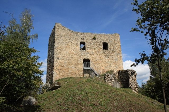
The castle ruin Lobenstein is a former, presumably High Medieval noble castle in the municipality of Zell northeast of Regensburg in the Upper Palatinate district of Cham in Bavaria. The castle ruin is freely accessible at any time and is used as a viewpoint.
The castle ruin is located in the front Bavarian Forest, immediately north above the village of Zell on the 564.6-meter-high Zeller Schlossberg, about 27 kilometers northeast of Regensburg. It consists of a large trapezoidal residential tower, which is located on the rocky summit, and a vanished building next to the summit area, of which only faint ramparts are still visible.
Nearby are other former medieval castles, only a few kilometers north-northwest of the Burgstall Katzenrohrbach north of the village of the same name and a little further north the Burgstall Kirchenrohrbach or Gußstein on the northern slope of the river Regen. Another former castle stood in the northwestern village of Hatzelsdorf, to the southeast lies the castle ruin Sengersberg near the village of Au on the mountain of the same name, to the southwest the castle ruin Siegenstein and to the northeast the castle Regenpeilstein.
Lobenstein Castle, whose origin is often placed in the 14th century in literature, may have been founded as early as the early 12th century, because in a tradition of Reichenbach Monastery from the mid-12th century, the two presumed brothers "Othmar" and "Rizman de Lobeneke" are mentioned. They were ministeriales of the Diepoldinger counts, whose namesake ancestral seat Lobeneck probably refers to the later Lobenstein Castle. In the masonry on the north and northeast side of the residential tower, remnants of an earlier building, which was built over by the current residential tower, can still be found today. This castle probably served at that time to secure the margravial dominion to the west.
At an unknown time, the Counts of Peilstein came into possession of the presumably destroyed Lobenstein Castle. In 1339, "Eiban von Peilstein" sold his castle site near Zell to "Eberhard Hofer von Hof". On May 23, 1340, he received permission from Emperor Ludwig the Bavarian "to build the castle site near Zelle, which he bought from Iban von Peilstein, as it is useful to him", i.e., to rebuild the ruinous predecessor castle, but Eberhard had to grant the emperor the right of opening against assurance of imperial protection. The Hofers were ministeriales of the Wittelsbachs, who had their ancestral seat at Hof Castle on the Regen, but then made Lobenstein Castle their main seat, and from 1342 called themselves Eberhard, Hofer von Lobenstein. They had their family tomb in the former Walderbach Monastery and in the Catholic parish church Mariä Himmelfahrt in Zell.
From 1380, Lobenstein is referred to as the seat of a Hofmark, where the Hofers appointed their own judges. "Seifried Krumbeck" is attested as the first. In 1369, "Kalhoch Hofer" called himself Pfleger zu Lobenstein, and in 1373, "Eberhard Hofer" did likewise.
A renewed destruction of the castle took place during the Hussite Wars, presumably during the campaign against Nittenau in 1428. However, it is said to have been uninhabited already at this time and to have been abandoned in favor of the new residence in Zell.
Afterwards, Lobenstein Castle was rebuilt nonetheless, which is also shown by the secondarily installed masonry in the interior of the residential tower.
The Hofers became robber knights in the times after the Hussite Wars; "Degenhard Hofer" killed several ducal subjects. Thereupon, Lobenstein Castle was conquered in 1443 by Duke Albrecht III of Bavaria-Munich due to robber knighthood. Afterwards, the Hofers received the castle back as a fief, granting the duke the right of opening.
In 1468, the castle was in the joint possession of the brothers Dietrich and Hans Hofer. However, Hans again engaged in robber knighthood, which is why his share of the castle was taken from him in the same year by the Wittelsbach Count Palatine Otto II. Dietrich also handed over his part of the castle to the Count Palatine as a true male fief and promised eternal opening. Both brothers again granted the Count Palatine the right of opening, after Hans also regained possession of his part of Lobenstein Castle.
Dietrich Hofer nevertheless joined the Löwlerbund in 1489, which rebelled against Duke Albrecht IV, placed the castle under the protection of the Bohemian Duke Wladislaw II, and declared a feud against Duke Albrecht. Lobenstein Castle was then conquered by ducal troops, presumably in the same year. Dietrich's son Wolf Hofer only got it back in 1507, after he had pledged obedience as a vassal. In 1516, the brothers Jörg and Wolf Hofer paid homage to the Counts Palatine Ludwig V and Philipp, took the castle as a perpetual fief, and granted permanent opening.
"Schloss Lobenstein" was, after border disputes between Bavaria and the Palatinate in 1530, assigned to the "Young Palatinate" on April 11, 1538, which was founded after the Landshut War of Succession. In 1526, the owners of Lobenstein were still referred to as Bavarian subjects. The Hofmark was in the possession of Jörg Hofer until 1550, from him it passed to the brothers Wolf Dietrich and David Eitel. In 1557, David became the sole owner, but since he was in debt, he tried in vain in 1558 to sell the property to the Barons zu Rhein.
In 1556, the castle is described as "...uninhabited for about 20 years...", when the castle was abandoned as a residence is not precisely known, possibly already after its conquest in the Löwler War. Also in 1689, Lobenstein is described as "...a desolate place and mere pile of stones...", although a view from the second half of the 16th century still shows the castle buildings under a roof.
However, the Hofers of Lobenstein and Zell were certainly residing at this time in the castle in Zell, mentioned in 1556 as "...a Hofpau zu Zell...".
The last Hofer of Lobenstein and Zell was Hans Georg Hofer, who is traceable from 1593. However, the Protestant had to emigrate to Regensburg in 1629, after the re-Catholicization began during the Thirty Years' War. He still called himself after Lobenstein and Zell in 1637, although all his attempts to regain possession of the lordship had failed.
The final destruction of Lobenstein Castle occurred shortly thereafter in 1633 by Swedish troops. The heirs of Hans Georg Hofer had to sell the ruin in 1649 to the Bohemian Baron Georg Thomas von Herstenzky zu Herstein und Welhartitz, as they could not rebuild the complex. The Baron, on the other hand, presumably intended to rebuild the castle; he paid homage to the sovereign in 1652. However, no reconstruction took place; Georg Thomas sold the lordship in 1665 to Baron Hans Peter von Salis. After his death in 1670, the fief reverted to the sovereign. From 1709, the son-in-law of Baron Hans Peter's widow, Conrad Thomas Rummel von Lonnerstadt, was the owner of the two estates in Zell and Lobenstein. In 1737, the castle is again mentioned as "...the old collapsed castle Lobenstein...".
The estates remained in the Rummel family until 1806, then the property passed by inheritance to the von Frank family.
Today, only the residential tower, preserved up to three stories high, remains of the former castle; it is freely accessible and now serves as an observation tower. Of the remaining buildings, only ramparts and ditches, partly heavily overgrown with trees and bushes, have been preserved.
The ruin can be easily reached on foot from Zell via a signposted path.
The ruin, registered as a monument by the Bavarian State Office for Monument Protection, bears the monument number D-3-72-167-6.
Description of the complex+
The ruin of the hilltop castle lies on and around the highest point of the Zeller Schlossberg on a triangular hill, which is partly covered with rounded granite rocks. The Schlossberg drops very steeply, especially to the south, into the valley of the Perlenbach, and the west and east sides of the mountain also drop steeply; only the northern side of the mountain transitions into a somewhat gentler slope, which then rises again to an adjacent hilltop.
The area of the single-part, rather small summit castle has approximately the shape of a trapezoid, and had a maximum length of about 65 meters and a width of 30 meters.
The castle complex was surrounded by a curtain wall, of which a rubble wall up to 1.8 meters high is still recognizable in the eastern and northeastern areas. In the remaining area, especially in the south of the complex, the wall is only recognizable as a terrace edge.
On the naturally poorly protected north and northwest sides of the former castle, a ditch is located in front of the curtain wall.
Accesses to the complex could have been in the area of the current driveway in the middle of the east side, and possibly on the west side.
In the southern and partly eastern area of the complex was the castle courtyard, located in the lowest part of the castle complex. On the northwest side of the castle complex stood an elevated residential building with dimensions of approximately 28 by 16 meters, of which today only the foundations and a collapsed cellar vault are recognizable. A 16th-century view shows the building as a two-story structure with a hip roof. The north side of this building stood only a few meters behind the curtain wall, creating a very narrow, presumed Zwinger area here.
On the highest point of the complex, in the northeast area, stood a residential tower, which was connected to the northeast side of the residential building.
The tower stands on several granite boulders that were integrated into the tower's masonry. The rocks also appear in the basement. Small cave-like spaces formed between the rocks at the north and west sides of the tower base, which were closed with facing walls.
The residential tower had the shape of a trapezoid, three floors and a basement. They are well preserved today, except for the second upper floor. The tower measures 15.5 by 9.5 to 13.0 meters, and is built of layered quarry stone masonry with corner quoins. The masonry on the ground floor is up to 2.4 meters thick, the northeast and southeast corners of the tower are chamfered.
On the north and northeast side, in the lower area, masonry of an older predecessor building can be seen, which clearly distinguishes itself from the rest of the masonry. It could date from the 12th-century castle.
Under the eastern half of the residential tower is a brick-vaulted cellar with a small slit window facing east; the remaining floors were originally divided by beam ceilings into three equally sized rooms. The visible subdivisions, vaults, attached walls, and pillars in the interior of the tower were presumably installed during the 15th century. At that time, the quarry stone masonry in the interior was plastered, as remnants of the preserved plaster show.
The access to the tower is on the ground floor; on the west side of this floor is a slit window that tapers outwards. On the north and east sides there are also vaulted window niches; the eastern one still shows the reveal of the rectangular window and side benches. These and the remaining reveals of the residential tower were probably added during renovations in the 1970s.
The southeast corner in the interior of the tower was subsequently separated by walls on the ground floor and first floor, creating a very narrow and barrel-vaulted room in the northeast corner, which now extends over two floors.
The 1st upper floor certainly served as the main living floor; here there are five segmental arched window niches, some with preserved seating benches. This floor is covered by two barrel vaults running parallel from north to south, of which today only the springings of the vaults and the intervening pillar on the south side are preserved. In this floor, too, the southeast corner has been separated by masonry, but this room is also spanned by a barrel vault running from north to south.
Not much remains of the 2nd upper floor of the residential tower; it now serves as an observation platform. Only on the west side of this floor is a higher wall remnant preserved, in which there is a vaulted window. At the northeast corner there is another opening, on the outside of the tower there are two corbels; it may be a latrine bay.
On the southeast corner of the tower, there is a polygonal annex on the outside, which has a round floor plan on the inside; this could be the remnant of a round tower flanking the entrance.
Take Mobile History with you
You are reading this text for free. Premium adds what matters on the road: descriptions read aloud, sites found through your camera, whole regions taken offline.
- Every description, including the ~17,700 Premium sites
- Audio guide: have descriptions read to you on location
- AR finder: see sites through your camera, with distance and bearing
- Unlimited saved sites
14 days free, then from €2.99 a month. Cancel anytime.
Source: Wikipedia · Licence: CC BY-SA 4.0
This description draws on the facts documented in the linked Wikipedia article; Wikipedia content is licensed under CC BY-SA 4.0. Wording and editing: Mobile History.
Location: 49.1471, 12.4085