The remains of the Castle can be visited
CastleHaldenstein
Lichtenstein Castle (Ruin) (Haldenstein)
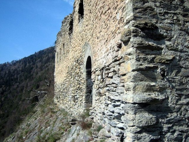
Lichtenstein Castle is a ruin above the municipality of Haldenstein in the Swiss canton of Graubünden.
Location+
Lichtenstein Castle is situated on a rocky ridge high above the Rhine Valley and is one of the three castles in the municipality, alongside Grottenstein Castle and Haldenstein Castle. It can be easily reached from the village in half an hour via a narrow road (no vehicle access). Due to its appearance - the ruin resembles a reclining cat - Lichtenstein is also popularly known as Katzenburg (Cat Castle).
As archaeological finds prove, the site in the natural saddle north of the castle, known as the Hexenbödeli, was settled from the Neolithic period to late antiquity.
The Lords of Lichtenstein first appear in historical records on June 26, 1180: at that time, Henricus de Lihtensten was entered into the Chur necrology. The castle likely already existed then, while the neighboring Grottenstein Castle and especially Haldenstein are probably somewhat younger. Still in the 12th century, the family seems to have split into a Lichtenstein and a Haldenstein branch; this can be concluded from the quite similar coats of arms of the families.
Just a hundred years later, the Lichtensteins disappeared from the records again: on March 22, 1275, with Knight Ulrich von Lichtenstein, their last secular representative died. A canon Rudolf von Lichtenstein is last mentioned in 1282. The inheritance of the Knights of Lichtenstein and their castle now fell to their relatives, the von Haldensteins. There, the name Lichtenstein appears as a given name: from 1351 to 1386, a Lichtenstein von Haldenstein is mentioned in documents as the youngest of four brothers.
In 1396, the castle is last mentioned in a document: at that time, after a feud between the Bishop of Chur and Ulrich Brun von Rhäzüns, Anna von Haldenstein and her husband, Christoph von Hertenegg, as episcopal followers, reconciled with Brun. This was recorded in writing "ze Liehtenstain uff der vesti". In the 15th century, Lichtenstein seems to have been abandoned. In 1479, a path "der gen Liechtenstein gat" (that goes to Liechtenstein) is still mentioned, but later there are no more references. There are no signs of a violent destruction of the complex. Around the middle of the 16th century, the castle was first described as a ruin.
In 1662, in the midst of the Bündner Wirren (Graubünden Troubles), Lichtenstein was occupied by Alois Baldiron with a troop of about 200 men. They were supposed to make access to the Bündner Oberland difficult for the Prättigauers, but they ran out of drinking water and provisions after only three days. After that, Lichtenstein was finally left to decay. Only in the 20th century were minor preservation measures carried out on the masonry.
Complex+
The remaining wall remnants consist of rather small, flat rubble stones, many of them in opus spicatum (herringbone pattern). On the artificially leveled meadow area northwest of the ruin, no more wall remnants are present, but it certainly also belonged to the castle. The original gate, which led into the enceinte in the northeast, was later walled up; a later gate could not be determined.
The three-story residential wing formed an elongated rectangle with a ground-level round-arched door with tuff jambs and a wooden lintel on the SE side, which was only accessible via a (now disappeared) wooden structure. Today, the door leads directly into the abyss. A vertical joint in the NW wall indicates a subsequent extension of the building. There are no traces of an internal subdivision of the wing. Inside the residential wing is a well-preserved tank cistern with a rectangular floor plan, vaulted ceiling, and brick-grit plaster.
Take Mobile History with you
You are reading this text for free. Premium adds what matters on the road: descriptions read aloud, sites found through your camera, whole regions taken offline.
- Every description, including the ~17,700 Premium sites
- Audio guide: have descriptions read to you on location
- AR finder: see sites through your camera, with distance and bearing
- Unlimited saved sites
14 days free, then from €2.99 a month. Cancel anytime.
Source: Wikipedia · Licence: CC BY-SA 4.0
This description draws on the facts documented in the linked Wikipedia article; Wikipedia content is licensed under CC BY-SA 4.0. Wording and editing: Mobile History.
Location: 46.8845, 9.5264