The remains of the Castle can be visited
RuinLichtenberg
Lichtenberg Castle (Ruin)
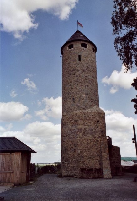
Lichtenberg Castle is located in the north of the town of Lichtenberg, on the western edge of the Selbitz Valley. The town belongs to the Hof district in the Bavarian administrative region of Upper Franconia.
The castle was probably built in the 12th century. Whether a predecessor building existed has not been conclusively clarified. The Dukes of Merania are considered as potential builders. They died out in 1248 with the death of Duke Otto VIII. Through his daughter Beatrix, who was married to Hermann II of Orlamünde, the lordship and castle passed by inheritance to the Counts of Orlamünde.
Through an inheritance division in 1414, Count Sigismund (1406–1447) received the complex. As a result of conflicts between the Counts of Orlamünde and the Landgraves of Thuringia, he had to pledge it as a fief to Elector Frederick I of Brandenburg in 1427. A short time later, the castle was sold to Caspar von Waldenfels. In 1430, the castle was successfully defended against the Hussites, and in 1444, during the Waldenfels Feud, against a Nuremberg contingent. In the Second Margrave War, the castle was destroyed in 1554 by imperial troops under Heinrich von Plauen while pursuing Margrave Albert Alcibiades.
From 1560, a new castle-like building was constructed. This was sold in 1618 by the brothers Christoph III and Hans Rudolf von Waldenfels to the Lithuanian-Polish Prince Janusius Radziwill. Through his widow, the castle and lordship passed to Margrave Christian of Brandenburg-Bayreuth in 1628.
In 1634, the castle was burned down by imperial troops during the Thirty Years' War. Restored, the existing buildings burned down again in 1682. A reconstruction did not take place.
Description+
Lichtenberg Castle rises immediately adjacent to the historic town center of Lichtenberg. Lichtenberg received town rights very early and is today one of the small towns that clearly show their historic core. The area of the historic town center is surrounded by defensive walls, thus offering extended protection for the castle area. The main street, which passes the town hall, gradually ascends and leads to the castle area, which is located on a hill to the north and, similar to a mountain spur, is difficult to access from other directions.
The castle area is still clearly recognizable today. Elevated buildings from various eras delineate the area towards the town. In the castle courtyard stands the reconstructed keep, whose lower section dates from the Middle Ages. Extensive cellar systems have also been preserved, which have only recently undergone renovation. The sides facing away from the town reveal parts of the curtain wall or a zwinger. The elevated position offers a comprehensive view of the mountains and valleys to the north.
Take Mobile History with you
You are reading this text for free. Premium adds what matters on the road: descriptions read aloud, sites found through your camera, whole regions taken offline.
- Every description, including the ~17,700 Premium sites
- Audio guide: have descriptions read to you on location
- AR finder: see sites through your camera, with distance and bearing
- Unlimited saved sites
14 days free, then from €2.99 a month. Cancel anytime.
Source: Wikipedia · Licence: CC BY-SA 4.0
This description draws on the facts documented in the linked Wikipedia article; Wikipedia content is licensed under CC BY-SA 4.0. Wording and editing: Mobile History.
Location: 50.3852, 11.6789