The remains of the Castle can be visited
RuinHartau
Karlsfried Castle (Ruin) (Hartau)
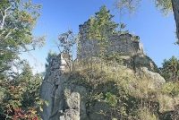
Karlsfried is the ruin of a hilltop castle in the Zittau Mountains. It is located approximately halfway between the Zittau village of Eichgraben and Lückendorf, on a rocky ridge - an offshoot of the Straßberg, very close to State Road 133.
Karlsfried Castle was built in 1357 by order of Emperor Charles IV by Burgrave Ulrich Tista von Liebstein. It was not intended as a residence, but merely served as a fortified toll station on a trade route (Gabler Imperial Road) between the Bohemian heartland and Upper Lusatia. Tolls were collected here; in addition, the castle offered merchants accommodation and escort. In 1364, Zittau became the tenant of the castle for 300 Schock of Prague Groschen.
In 1412, Landvogt Hinko Berka von Dubá took over the castle.
In 1421, the castle withstood a siege by the Hussites, but was then burned down during a second siege in January 1424. Afterwards, the castle was rebuilt once more under Emperor Sigismund. Its new owner, Jan von Wartenberg, undertook raids into the surrounding area from there. To prevent this, the city of Zittau bought the castle in 1442 and had it demolished. Many of its ruins were carried away and reused in the surrounding area as inexpensive building material. For example, in 1690, stones were broken off for the Lückendorf church. The remaining demolition took place in 1721 as building material for Zittau.
What remains of Karlsfried to this day are the remnants of an entrance tower and a small palas with a square keep. The rampart, which formed the border fortification in the valley below the castle, can also still be recognized. This type of castle is also called a "Talsperre" (valley barrier) in German literature.
The Karlsfried ruin lies inconspicuously in the forest today, directly next to the Zittau–Lückendorf highway. It is accessible on foot both from the road and from the east via hiking trails and can be visited free of charge at any time. However, no guided tours take place, and apart from a nearby shelter and well-signposted hiking trails, there is no infrastructure whatsoever.
Take Mobile History with you
You are reading this text for free. Premium adds what matters on the road: descriptions read aloud, sites found through your camera, whole regions taken offline.
- Every description, including the ~17,700 Premium sites
- Audio guide: have descriptions read to you on location
- AR finder: see sites through your camera, with distance and bearing
- Unlimited saved sites
14 days free, then from €2.99 a month. Cancel anytime.
Source: Wikipedia · Licence: CC BY-SA 4.0
This description draws on the facts documented in the linked Wikipedia article; Wikipedia content is licensed under CC BY-SA 4.0. Wording and editing: Mobile History.
Location: 50.8347, 14.7925