The remains of the Castle can be visited
RuinBad Driburg
Iburg Castle (Ruin) (Bad Driburg)
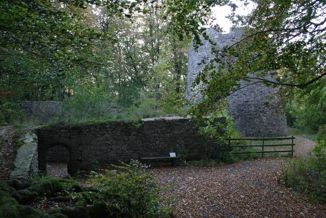
The Iburg is the ruin of a hilltop castle in the Eggegebirge near Bad Driburg in the district of Höxter in North Rhine-Westphalia. Its origins date back to the Saxon Wars.
The castle complex, freely accessible all year round, is a popular excursion destination together with the Kaiser-Karls-Turm observation tower and the Sachsenklause restaurant.
Geographical Location+
The ruin is located in the central part of the Eggegebirge within the Teutoburg Forest / Eggegebirge Nature Park on the mountain of the same name, Iburg (), also called Iberg, which protrudes as a wooded and narrow mountain spur into the eastern adjacent valley of Bad Driburg. Its city center is about 1.1 km (as the crow flies) northeast of the castle, and about 1.4 km west-southwest lies Hausheide (), one of the highest elevations of the Eggegebirge.
Directly bordering the Iburg to the northeast stands the Kaiser-Karls-Turm (), built in 1904, from which a wide view to the east over Bad Driburg and its surroundings is possible and which is visible from afar from this direction, and next to it the Sachsenklause excursion restaurant, opened in 1925.
The Iburg dates back to a Saxon refuge castle from the 8th century. Local legends also want to see it as the location of the Irminsul. New research relates the mention of castrum Juberg in the Frankish Imperial Annals for the year 753 to the Iburg near Bad Driburg, not to Bad Iburg near Osnabrück.
Archaeological research in 2000/2003 found two limestone walls in the western "Sachsenwall" (Saxon Wall), which are assigned to the Saxon and subsequent Frankish castle periods. Outwardly, the wall was supported by mighty palisades dug into the bedrock.
After the conquest, Charlemagne had a St. Peter's Church built in the formerly Saxon complex, which was an archdeaconry church from 1231. He donated the castle to the Paderborn Church in 799. From 1134, it briefly housed a Benedictine convent, before Bishop Bernhard II of Paderborn had a 180 by 50 meter stone knight's castle built here in 1189. In the 15th century, the castle lost its importance and was finally destroyed by Otto von Braunschweig in 1444 and not rebuilt thereafter. After the extinction of the Knights of Driburg, the city of Driburg inherited the castle and adjacent forests.
In 1900, the Iburg ruins were uncovered and archaeologically investigated for the first time. Since then, several research excavations and conservation measures have been carried out. Information boards explain the findings and the history.
Complex+
Various wall remains and the keep of the Iburg are preserved, which were partially renovated in the 20th century. A rampart system, also called "Sachsenmauer" (Saxon Wall), which encloses an area of about 4 hectares, is also preserved.
Transport Connection+
On the eastern slope of the mountain, about 80 m below the Iburg, the federal road 64 runs in a long curve in the section between Herste, Bad Driburg and Buke. From the parking lot (approx. ) at the Iburgstadion on the western edge of the city, a 1.15 km long path leads uphill, tunneling under the B 64, to the Kaiser-Karls-Turm next to the ruin. The Eggeweg hiking trail, which is part of the Hermannshöhenweg and the European long-distance hiking trail E1 and runs mainly on the main Egge ridge, passes about 600 m west of the Iburg.
Take Mobile History with you
You are reading this text for free. Premium adds what matters on the road: descriptions read aloud, sites found through your camera, whole regions taken offline.
- Every description, including the ~17,700 Premium sites
- Audio guide: have descriptions read to you on location
- AR finder: see sites through your camera, with distance and bearing
- Unlimited saved sites
14 days free, then from €2.99 a month. Cancel anytime.
Source: Wikipedia · Licence: CC BY-SA 4.0
This description draws on the facts documented in the linked Wikipedia article; Wikipedia content is licensed under CC BY-SA 4.0. Wording and editing: Mobile History.
Location: 51.7302, 9.0041