The remains of the Castle can be visited
RuinImmenstadt
Hugofels Castle (Ruin)
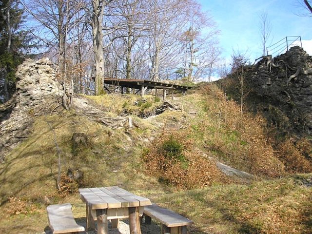
The few remains of Hugofels Castle lie on a wooded ridge above the Great and Small Alpsee lakes near Immenstadt in the Allgäu (Oberallgäu district, Swabia). The fortress, together with the neighboring Rothenfels Castle, formerly formed a large double castle complex.
The hilltop castle on the highest point of the scenic ridge above Immenstadt was probably built in the first half of the 13th century. Its core was a residential tower unique in the German Alpine region, with four small corner roundels (tourelles), which probably goes back to older French or Swiss (Thun) models. The tower was probably originally only an outwork of Rothenfels Castle, located about 170 meters to the southwest. This residence was built at the same time by the Lords of Schellenberg and acquired around 1332 by the Counts of Montfort-Tettnang.
Around 1440, Count Hugo XIII of Montfort settled in the double castle and, after a fire, initiated extensive renovations and extensions from 1462. The cellar of the keep was vaulted and the south wall partially rebuilt. A new access to the residential tower was created here, protected on both sides by loopholes. At that time, however, the castle seems to have been used only as a storehouse. Apparently, people preferred the more comfortable life at Rothenfels Castle, which was located a little lower.
Allegedly, both castles were unsuccessfully besieged by the rebels in 1525 during the German Peasants' War. Of historical significance for castles is the tradition that Count Wolfgang of Montfort entrenched himself with his servants in the residential tower for about 20 weeks during the siege. Since the end of the 20th century, some researchers have questioned the function of such strong residential towers (keeps) and bergfrieds as places of retreat during sieges.
In 1560, only a watchman lived in the large main tower.
When the Lordship of Rothenberg was acquired by the Counts of Königsegg-Aulendorf in 1567, the double castle began to fall into disrepair. The new lords of the castle resided in the town castle in Immenstadt. Around 1600, the first parts of the castle were demolished, and finally, in 1626, the roof truss was removed.
In 1875, the castle became the property of the city of Immenstadt. From 1932 to 1939, the cellar vault was excavated, and the small tank cistern in the northeast corner of the tower was discovered.
In 1994, a structural investigation of the ruin remains was carried out. As part of the development of the "Allgäu Castle Region," the masonry was cleared of its sometimes dense vegetation, a modern information board was erected in the castle area, and the access path was renovated. Since then, the prohibition sign at the castle entrance, which still forbade entry to the castle site in 2007, has disappeared.
The ruin is in a desolate state. The preserved cellar vault is only accessible via a round light or ventilation shaft in the ceiling vault (closed).
Description+
The approximately square residential tower stands on the highest peak of a narrow ridge northeast of Rothenfels Castle. Between the two castles lies the former outer bailey, which was formerly secured by an outer gate and is still inhabited today.
West of the tower, the terrain indicates a separate outwork of Hugofels Castle. To the east, there are three material pits on the ridge, which are probably to be interpreted as quarries.
The formerly probably four- to five-story residential tower (approx. 21 x 21 meters) is embedded in an approximately five-meter-high cone of debris. The south wall, made of large Nagelfluh boulders, is best preserved. This conglomerate rock is abundant everywhere in the vicinity (Nagelfluhkette). The two corner roundels (diameter approx. 7.7 meters), which now serve as viewpoints, are clearly visible.
Inside, a provisional roof construction protects the shaft in the barrel vault of the approximately five-meter-high cellar. The room, currently only accessible by rope, is partially buried. In the northeast corner, about three meters deeper, lies the rectangular tank cistern, from which water could be drawn from the upper floors through a scooping shaft. The original access to the cellar vault is still recognizable but has been inaccessible for decades.
To the south, below the castle rock, an approximately 1.5-meter-high rampart is visible, accompanied by a V-shaped inner ditch. Approximately 90 meters west of the main castle mound, remains of a short transverse wall have been preserved at the beginning of the ridge.
Take Mobile History with you
You are reading this text for free. Premium adds what matters on the road: descriptions read aloud, sites found through your camera, whole regions taken offline.
- Every description, including the ~17,700 Premium sites
- Audio guide: have descriptions read to you on location
- AR finder: see sites through your camera, with distance and bearing
- Unlimited saved sites
14 days free, then from €2.99 a month. Cancel anytime.
Source: Wikipedia · Licence: CC BY-SA 4.0
This description draws on the facts documented in the linked Wikipedia article; Wikipedia content is licensed under CC BY-SA 4.0. Wording and editing: Mobile History.
Location: 47.5700, 10.2073