The remains of the Castle can be visited
CastleRothenbrunnen
Hochjuvalt Castle (Ruin) (Rothenbrunnen)
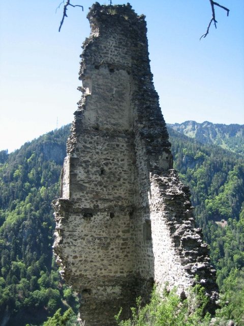
Hochjuvalt (often mistakenly referred to as Niederjuvalt), along with Innerjuvalt, was one of the two castles in the municipality of Rothenbrunnen in the Swiss canton of Graubünden. The name derives from 'Jugum altum' (= high yoke).
The ruin is clearly visible on a narrow rock spur about 200 meters above the Hinterrhein. The original castle path is buried. Today, it can be reached in about half an hour via a very steep, narrow path marked with blue crosses, starting from the paved forest road. The turn-off is after the tank traps, shortly before the second fork in the road, but it is difficult to find. Sure-footedness and a head for heights are required for the last few meters of ascent.
Of the once five-story tower of Fest Hochjuvalt, only the west corner remains, with corner stones with chamfered edges without bosses and walls with Rasa-Pietra plaster with joint lines; remnants of a smooth plaster are also found. An external loggia was attached on the third floor, and a window with a window seat has been preserved on the floor above. At the highest point of the complex, on top of the narrow rock head, there are remains of a two-part building. Only a few wall remnants of a younger rectangular building on the southwestern forecourt remain. The former access was cut into the rock and approached from the northwest.
At the foot of the massive rock on the old valley road from Chur to Splügen, there was a road barrier with a customs post as an outer bailey; individual wall remnants and beam holes of two gates are still preserved. This complex at the entrance to the Domleschg consisted of a walled courtyard with two square towers through which the road passed. The remains of these structures have been severely damaged by the construction of a new road, by military installations, and by rockfall. Currently (spring/summer 2011), the ruin of the outer bailey is undergoing extensive restoration.
Hochjuvalt is considered the older of the two Rothenburg castles and was probably built in the 12th century as the seat of the Lords of Juvalt. After initial independence, the family served the Bishop of Chur and was first mentioned around 1140 and later in 1149. This concerned a legal dispute between the Church of Chur and those of Castrisch over the serf Guta von Zizers, in which a Siegfried von Juvalta and his sons acted as mediators.
In the following centuries, the Lords of Juvalt appear several more times in documents. For example, in 1219, Ulrich von Juvalta was present at the peace treaty between the Bishop of Chur and the city-state of Como. In 1342, the two brothers Albert and Bartholomäus von Juvalt quarreled, and a five-member arbitration court decided that the castle with its people and goods belonged to Albertus, but Bartholomäus received the tithes and rents. In a division of inheritance in 1372, Egloff von Juvalt received the "vesti genannt Jufalt".
How Hochjuvalt came into the possession of the Lords of Rietberg is unknown. Johann, the Rietberger, who died on September 5, 1349, handed over all his fiefs and goods to his uncles from Landenberg, with Hochjuvalt being particularly mentioned alongside Rietberg. After an inheritance dispute, the Landenberg family renounced the castle in favor of the bishop. In the 15th century, the castle changed hands several times as a pledge. It is unclear whether and how severely Hochjuvalt was damaged in the Schams Feud of 1451. Around 1500, Hochjuvalt was probably abandoned, and around 1550, it was mentioned as a ruin.
Take Mobile History with you
You are reading this text for free. Premium adds what matters on the road: descriptions read aloud, sites found through your camera, whole regions taken offline.
- Every description, including the ~17,700 Premium sites
- Audio guide: have descriptions read to you on location
- AR finder: see sites through your camera, with distance and bearing
- Unlimited saved sites
14 days free, then from €2.99 a month. Cancel anytime.
Source: Wikipedia · Licence: CC BY-SA 4.0
This description draws on the facts documented in the linked Wikipedia article; Wikipedia content is licensed under CC BY-SA 4.0. Wording and editing: Mobile History.
Location: 46.7781, 9.4208