The remains of the Castle can be visited
CastleMuttenz
Hinterer Wartenberg Castle (Ruin)
The Wartenberg is a striking landmark of the Basel-Landschaft municipality of Muttenz. On the mountain stand the ruins of three medieval castles, which also bear the name Wartenberg.
The Wartenberg is an elevation southeast of the municipality, is part of the Tabular Jura and an offshoot of the Gempen plateau. Its highest point is at an altitude and towers over the village by a good 200 meters.
The height and design of the Wartenberg were excellently suited for representative and defensive purposes, and a Bronze Age complex, which had been used as a refuge, was discovered at the highest point. Arrowheads, a spear, knives and sickles, various ornaments, thousands of sling stones, and various stone tools were found. No remains of the complex itself were found due to the construction of the subsequent castles.
The three castle ruins of Wartenberg+
All three castles were 'cleared out' (loss of many archaeological findings) and 'restored' (loss and falsification of historical building fabric) during the castle romantic phase in the 1930s to 1950s. This should not be lamented here, however, as castle romanticism at least led to a broad public interest in the Middle Ages. The fortifications built during the Second World War also disturbed the historical building fabric.
Until the end of the 13th century, the three castles were a single unit. The Cathedral Chapter of Strasbourg appears as the first historically traceable owner of the three Wartenberg castles and the village of Muttenz. How the Strasbourgers came into possession of these lands can no longer be ascertained. Presumably, the three castles were already passed on as fiefs by the Strasbourg archbishops to the Counts of Homberg in the 11th century. The castles were inhabited not only by the Hombergers or, after 1250, by their successors from the House of Frohburg, the Neu-Hombergers, but also by their vassals, the Marschalk von Frohburg, who after 1250 also called themselves Marschalk von Wartenberg.
The House of Habsburg-Austria took over all three castles in 1306 and gave them as sub-fiefs first to the Basler zer Sunnen and then to Johann I von Habsburg-Laufenburg.
Hintere Burg (Rear Castle)+
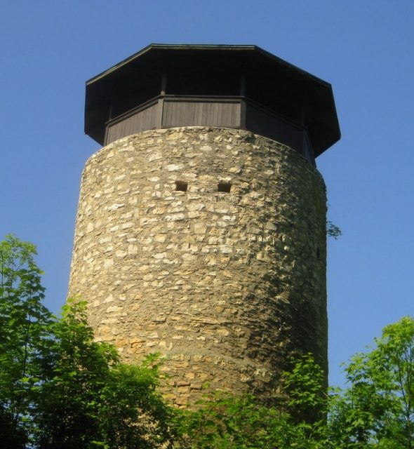
The Hintere Wartenberg is located on the southernmost spur of the Wartenberg, protected on three sides by a rocky slope and to the north by a neck ditch.
Layout
An elongated curtain wall surrounded the castle, built in the 13th century. In the southern area are the remains of a residential wing, which was directly integrated into the high enclosing wall. To the north stands a massive, still nine-meter-high round tower with a wall thickness of 1.8 m and a diameter of 6.2 m. In 1901, the tower was restored, supplemented with a covered wooden structure, and has since served as an observation tower.
The current castle gate in the still-standing wall on the east side is not historically documented: a breach in the wall was interpreted during restoration as the location of the former castle gate, and the gate jambs were then reconstructed according to their own ideas.
The rear castle came no later than 1296 as a fief to the Lords of Eptingen-Madeln, who at that time named themselves after the castle. In 1379, the castle - now as a fief of the Habsburg House of Austria - came to Petermann Sevogel and his descendants in the 15th century. During this time, the castle was already abandoned. It then passed by inheritance to the Lucerne Schultheiss Jakob von Hertenstein, who later transferred it - or the associated estates and rights - to the St. Georgenkirche in Rümlingen. In the 16th century, the city of Basel was able to acquire the Hintere Wartenberg from them.
Take Mobile History with you
You are reading this text for free. Premium adds what matters on the road: descriptions read aloud, sites found through your camera, whole regions taken offline.
- Every description, including the ~17,700 Premium sites
- Audio guide: have descriptions read to you on location
- AR finder: see sites through your camera, with distance and bearing
- Unlimited saved sites
14 days free, then from €2.99 a month. Cancel anytime.
Source: Wikipedia · Licence: CC BY-SA 4.0
This description draws on the facts documented in the linked Wikipedia article; Wikipedia content is licensed under CC BY-SA 4.0. Wording and editing: Mobile History.
Location: 47.5180, 7.6541