The remains of the Castle can be visited
CastleSchwarzenburg
Grasburg Castle (Ruin) (Schwarzenburg)
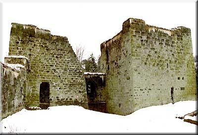
As the largest ruin in the Canton of Bern, but also due to its location on a sandstone cliff steeply falling to the Sense river, Grasburg has long been a destination for recreational excursionists and groups of students and scouts eager for suitable "robber" playgrounds. Its defiant remains of walls are now, however, partly threatened by collapse, and climbing on them is not without danger.
As much as is known about this castle from its Savoyard period in the 14th century, little is known about its beginnings. It is probably a clearing settlement from the High Burgundian period, which also had to guard a trade route. Around the turn of the millennium, there is talk of a follower of King Rudolf III named Reginfrid, who promoted the expansion of settlements in the previously forested Schwarzenburgerland. In the 10th and 11th centuries, the route from Uechtland to Thun was apparently upgraded, which is also evident from the founding of the Cluniac priory of Rüeggisberg (after 1070). The deep Sense gorge was crossed in front of Grasburg. This only appears in documents after the extinction of the Zähringer, now as the center of a larger dominion, namely the Schwarzenburgerland, including a bridgehead west of the Sense, which is also today Bernese Albligen. Presumably, the Zähringer had expanded the complex as a cornerstone of their territorial area expanding in the Rectory of Burgundy. After 1218, Grasburg was elevated to an imperial castle under the Hohenstaufen and inhabited by a family of ministeriales, the Lords of Grasburg. The oldest still existing parts of the walls with their sandstone and bossed ashlar blocks probably date from that time.
During the interregnum (approx. 1250-1273), Grasburg became a bone of contention between various expanding princely houses, the Counts of Kyburg, Savoy, and Habsburg. Rudolf von Habsburg finally asserted the fortress and entrusted it to an Uechtland nobleman, Ulrich von Baggenberg, as a ministerialis, but after his election as king in 1273, he returned it to the Empire. In 1310, as a result of a distraint, the Savoyards came into its possession. Until 1423, they had Grasburg and the associated dominion administered by castellans. Thanks to records and accounts, we are excellently informed about the building events and many details of life at the castle. Thus, we know from the documents – and not just from the ruins – a great deal about the structure of the castle. The main complex, crowned by a keep, with the knight's house, was located in the west, on the rocky outcrop of the mountain spur. Strong fortifications separated it from the large castle courtyard and the outer bailey, which was separated from the rear hill area by a deep ditch.
The dominion of Grasburg came into the possession of the cities of Bern and Fribourg in 1423 through sale. With the exception of the years 1447 and 1754, they jointly administered the Schwarzenburgerland until 1798. The seat of the bailiwick remained initially on the fortress above the Sense, technically improved and, after the Burgundian Wars, additionally protected in its front part by a shield wall. However, maintaining, preserving, and inhabiting the very extensive complex, stretching over 182 meters in length, became more and more arduous. In 1572, the administration was therefore moved to Schwarzenburg, and a new castle in the style of the time was built there, largely from demolition material from the old castle. Grasburg fell into disrepair. Despite repeated partial restorations, it is now in urgent need of securing. It has belonged to the city of Bern since 1894, which is preparing a comprehensive renovation.
Take Mobile History with you
You are reading this text for free. Premium adds what matters on the road: descriptions read aloud, sites found through your camera, whole regions taken offline.
- Every description, including the ~17,700 Premium sites
- Audio guide: have descriptions read to you on location
- AR finder: see sites through your camera, with distance and bearing
- Unlimited saved sites
14 days free, then from €2.99 a month. Cancel anytime.
Source: Wikipedia · Licence: CC BY-SA 4.0
This description draws on the facts documented in the linked Wikipedia article; Wikipedia content is licensed under CC BY-SA 4.0. Wording and editing: Mobile History.
Location: 46.8339, 7.3316